Lithuania Flag, Capital and Country Facts
Lithuania lies on the southeastern Baltic Sea and is the southernmost of the three Baltic states. Vilnius is located inland, while the coast only touches a comparatively small part of the national territory. The yellow-green-red flag combines a simple striped image with a history ranging from medieval statehood to restored independence.
Test your knowledge →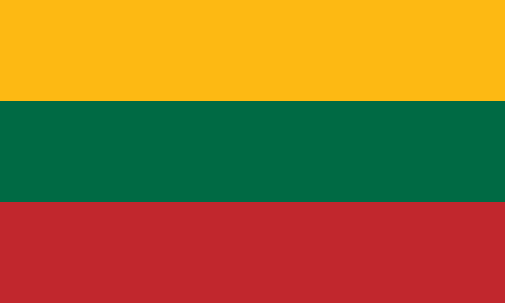
Lithuania at a glance
- Capital
- Vilnius
- Quiz continent
- Europe
- Languages in reference record
- Lithuanian (official language); other minority languages
- Currency
- Euro (EUR)
- Population
- 2,888,774 (2025, World Bank)
- Area
- 65,300 km²
- Coastal setting
- Not landlocked
- ISO codes
- LT / LTU
- Internet country suffix
- .lt
- Highest point
- Aukštojas, around 294 m
- Declaration of Independence
- 16 February 1918
- Restoration of independence
- 11 March 1990
- River Vilnius
- Neris
- Coastal landscape
- Curious frying
- Historical Great Power
- Grand Duchy of Lithuania
Lithuania Flag: Design, Meaning and History
Three equally high horizontal stripes are in yellow, green and red among each other. The national flag does not carry a coat of arms. Their colours resemble several African tricolors, but the order with yellow on top and green in the middle provides a clear indication of Lithuania.
The Factbook Archive combines yellow with fields and sun, green with forests and hope, and red with courage and commitment to the homeland. The simple tricolor can be distinguished from the historical state flag with the rider Vytis. The quiz expressly shows the yellow-green-red national flag.
Capital: Vilnius
Vilnius is located in the south-eastern interior at the confluence of Neris and Vilnia. The city name is associated with the smaller river Vilnia. The inland location distinguishes Vilnius from Riga and Tallinn, the other two Baltic capitals with immediate Baltic Sea location.
The historic centre of Vilnius has been a UNESCO World Heritage site since 1994. The city was an important center of the Grand Duchy of Lithuania and has a multi-layered religious and linguistic past. Today’s capital role can therefore be combined with a long city history without reducing all previous communities to a single modern national identity.
Practise this capital →Lithuania: Geography, History and Culture
Lithuania’s terrain consists mainly of lowlands and shallow hillside landscapes. The highest point of Aukštoja is only about 294 meters above sea level. Ice Age forms, lakes and rivers shape the space. The contrast to mountainous European countries is clear: Here, water bodies and gentle elevations rather than high passes and summits structure the landscape.
Lithuanian belongs to the Baltic branch of the Indo-European language family. The geographical designation “Baltic states” therefore does not mean a common language of all three countries: Latvian is also Baltic, while Estonian is Uralic. This distinction helps not to equate geographical groups and linguistic affinity. Within Lithuania, Polish- and Russian-speaking communities are also part of the country’s history.
The Grand Duchy of Lithuania was a large political space in the Middle Ages and early modern times. Modern independence was established in 1918 and restored in 1990 after Soviet rule. Both dates therefore appear in national remembrance. The UNESCO heritage complements this political history with urban planning, archaeology, coastal landscapes and the scientific surveying of the earth.
Curious frying
The Curonian Spit has been a World Heritage Site since 2000 and is shared with Russia. The narrow strip of land separates the Kurische Haff from the Baltic Sea. It illustrates the interaction of water, sand and human use on the Lithuanian coast.
Modern Kaunas
Kaunas was included in the World Heritage List in 2023 with its modernist architecture from 1919 to 1939. The entry focuses on the 20th century. Lithuania’s architectural history thus does not consist exclusively of medieval old towns.
Struve arc
Lithuania has measuring points of the cross-border Struve arc. This World Heritage entry documents historical geodetic surveying. It connects the country historically with a long north-south chain of other European countries.
Explore neighbouring and related places
 Belarus
 Latvia
 Poland
 Russia
What did you discover?
Sources and image credits
This English article draws on the institutional sources listed below. Figures and memberships retain their stated reference dates.
Source record: 2 November 2026. A translation does not change the reference date of a figure or membership list.
- github.com/factbook/factbook.json/blob/144d6977b2b01ac1cbd220de754c0a005616760b/europe/lh.json
- data.worldbank.org/indicator/SP.POP.TOTL
- whc.unesco.org/en/statesparties/lt
- github.com/mledoze/countries