Slovakia Flag, Capital and Country Facts
Slovakia is located in the Central European landlocked region between the Carpathians and the Danube. Bratislava is located far to the west, while the high peaks of the Tatras shape the north. The white-blue-red flag belongs to the Pan-Slavic color tradition. Their coat of arms with double cross and three hills helps to distinguish them safely from similar tricolors.
Test your knowledge →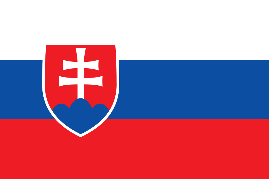
Slovakia at a glance
- Capital
- Bratislava
- Quiz continent
- Europe
- Languages in reference record
- Slovak (official language); recognised minority languages
- Currency
- Euro (EUR)
- Population
- 5,413,813 (2025, World Bank)
- Area
- 49,037 km²
- Coastal setting
- Landlocked
- ISO codes
- SK / SVK
- Internet country suffix
- .sk
- Highest summit
- Gerlachovský štít, 2.655 m
- Great mountains
- Carpathians
- Large river
- Danube
- Another important river
- Waag/Váh
- Autonomous State
- Since 1 January 1993
- Historical capital name
- Pressburg/Pozsony
Slovakia Flag: Design, Meaning and History
Three equally high horizontal stripes are in white, blue and red. A red-white-blue heraldic shield is offset from the hoist side over the strip. In the sign is a white double cross on three blue hills. This coat of arms makes the flag clearly recognizable opposite the Russian white-blue-red tricolor.
White, blue and red are among the Pan-Slavic colors. The double cross and the Dreiberg take up historical heraldic signs. When comparing with Slovenia, it is therefore not enough to determine only the same colors: the shape of the coat of arms and its concrete motifs must be considered. The Slovak sign is red and expressly shows a double cross.
Capital: Bratislava
Bratislava is located on the Danube in the extreme west of Slovakia. The city is close to the borders with Austria and Hungary. This peripherality distinguishes them from a centrally located administrative location in the country and at the same time explains their close connections in the central Danube region.
The city is also known in history under the names Pressburg and Pozsony. Different names refer to the multilingual history of the region. Bratislava became the capital of the new state with the emergence of independent Slovakia on 1 January 1993; however, its urban significance dates back many centuries.
Practise this capital →Slovakia: Geography, History and Culture
In the north and in the middle dominate the Carpathians with several mountain ranges. The High Tatras reaches 2,655 meters at Gerlachovský štít. In the south and southwest are deeper plains and rivers. Slovakia is therefore not exclusively a high mountain country: mountains and lowlands complement each other and offer very different conditions for settlement, agriculture and transport.
The Danube connects the west of the country with a large European river system. Other waters such as the Waag open up the inland area. The lack of access to the sea therefore does not imply geographical isolation. Bratislava’s location on the river and at several borders in particular shows how a landlocked country can be closely integrated into larger transport and economic areas via river axes and neighbouring regions.
Slovak is a West Slavic language and closely related to Czech. The common history in Czechoslovakia explains many connections, but must not obliterate today's statehood. The peaceful dissolution of the common state led to two independent republics in 1993. Minority languages and the historical place names show at the same time that the space was never exclusively monolingual.
Banská Štiavnica’
The historic mining town and its technical monuments are part of the UNESCO World Heritage site. The site links urban history with raw material extraction and technical development. It complements the image of Slovakia as a mountainous country with a concrete historical form of economic use.
Caves over borders
The caves of the Aggtelek and Slovak Karst form a common world heritage with Hungary. The underground landscape follows natural rock spaces. The entry makes it clear that karst systems do not end at political borders.
Two Similar Country Names
Slovakia and Slovenia are different states. Bratislava belongs to Slovakia, Ljubljana to Slovenia. Because the flags also have similar colors, capital names and coat of arms motifs are particularly useful common learning aids.
Explore neighbouring and related places
 Austria
 Czechia
 Hungary
 Poland
 Ukraine
What did you discover?
Sources and image credits
This English article draws on the institutional sources listed below. Figures and memberships retain their stated reference dates.
Source record: 2 November 2026. A translation does not change the reference date of a figure or membership list.
- github.com/factbook/factbook.json/blob/144d6977b2b01ac1cbd220de754c0a005616760b/europe/lo.json
- data.worldbank.org/indicator/SP.POP.TOTL
- whc.unesco.org/en/statesparties/sk
- github.com/mledoze/countries