Mauritius Flag, Capital and Country Facts
Mauritius is located in the southwestern Indian Ocean east of Madagascar. A main volcanic island, coral reefs and other islands form a state with extensive historical connections. The four-color flag is unusually simple. Port Louis and the UNESCO sites Aapravasi Ghat and Le Morne make migration, colonial work systems and resistance to enslavement concretely traceable.
Test your knowledge →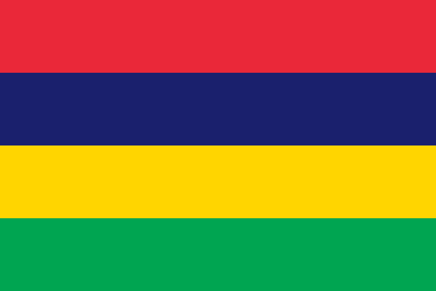
Mauritius at a glance
- Capital
- Port Louis
- Quiz continent
- Africa
- Languages in reference record
- Mauritian Creole, French and English in different functions
- Currency
- Mauritius-Rupie (MUR)
- Population
- 1,243,741 (2025, World Bank)
- Area
- 2,040 km²
- Coastal setting
- Not landlocked
- ISO codes
- MU / MUS
- Internet country suffix
- .mu
- Independence
- 12 March 1968
- Republic since
- 12 March 1992
- Another island
- Rodrigues
- Extinct bird
- Dodo
- Historical crop
- Sugar cane
- Mountain landscape
- Le Morne Brabant
Mauritius Flag: Design, Meaning and History
Four equally wide horizontal stripes are red, blue, yellow and green from top to bottom. There are neither coats of arms nor stars nor a corner field. Just the number four and the position of the blue stripe under red are good features. The government describes an aspect ratio of six to four for the flag.
According to the official account, red stands for the struggle for freedom and independence, blue for the Indian Ocean, yellow for the new light of independence and green for agriculture and the green island all year round. The flag was introduced in 1968. This national interpretation can be directly linked to independence from the United Kingdom.
Capital: Port Louis
Port Louis is located on the northwest coast of the main island. The port was developed into an administrative center in the French colonial period; its name refers to King Ludwig XV. The capital connects political headquarters and international trade links. Their protected coastal position was more important for ships than a central position in the interior of the island.
In Port Louis lies Aapravasi Ghat, today UNESCO World Heritage Site. The place documents the arrival and organization of contract workers after the abolition of slavery. This makes the port not only an economic institution, but also a central place of remembrance. Labour migration explains essential parts of Mauritian population and language history.
Practise this capital →Mauritius: Geography, History and Culture
The main island is of volcanic origin. Coastal plains rise to mountains and a central highland; offshore coral reefs characterize many coastal sections. The sea connects Mauritius with other islands of the Indian Ocean, while great distances to the African mainland affect transport and supply. The state also includes Rodrigues with its own island history.
Mauritian Creole is especially important in everyday life. French and English fulfil other functions in the media, education, administration and parliament. The languages should therefore not be pressed into a simple list of supposedly identically used official languages without explanation. Multilingualism is linked to French and British rule, as well as migration from Africa and Asia.
March 12 commemorates both the independence of 1968 and the introduction of the Republic in 1992. Sugar cane cultivation shaped a long economy and landscape; the factbook archive stand of 2025 also highlights services, industry and tourism. The memory of the extinct dodo complements this picture with the consequences of human intervention in sensitive island ecosystems.
Aapravasi ghat
The UNESCO site in Port Louis documents the history of contract work. She explains how global labour movements helped shape today’s Mauritius.
Le Morne
The cultural landscape Le Morne is also on the World Heritage List. It is connected with the memory of people who fled from enslavement.
The Dodo
The flightless Dodo lived in Mauritius and died after human settlement. It became a world-renowned example of the disappearance of island species.
Explore neighbouring and related places
 Algeria
 Angola
 Benin
 Botswana
 Burkina Faso
 Burundi
What did you discover?
Sources and image credits
This English article draws on the institutional sources listed below. Figures and memberships retain their stated reference dates.
Source record: 2 November 2026. A translation does not change the reference date of a figure or membership list.
- github.com/factbook/factbook.json/blob/144d6977b2b01ac1cbd220de754c0a005616760b/africa/mp.json
- data.worldbank.org/indicator/SP.POP.TOTL
- whc.unesco.org/en/statesparties/mu
- govmu.org/EN/Pages/National-Flag.aspx
- github.com/mledoze/countries