Madagascar Flag, Capital and Country Facts
Madagascar is located off the southeast coast of Africa in the Indian Ocean. The long geographical autonomy of the island explains many animal and plant species that only occur here. Antananarivo is located in the central highlands; the flag combines a white mast field with red and green, distinguishing itself from an ordinary three-lane tricolor.
Test your knowledge →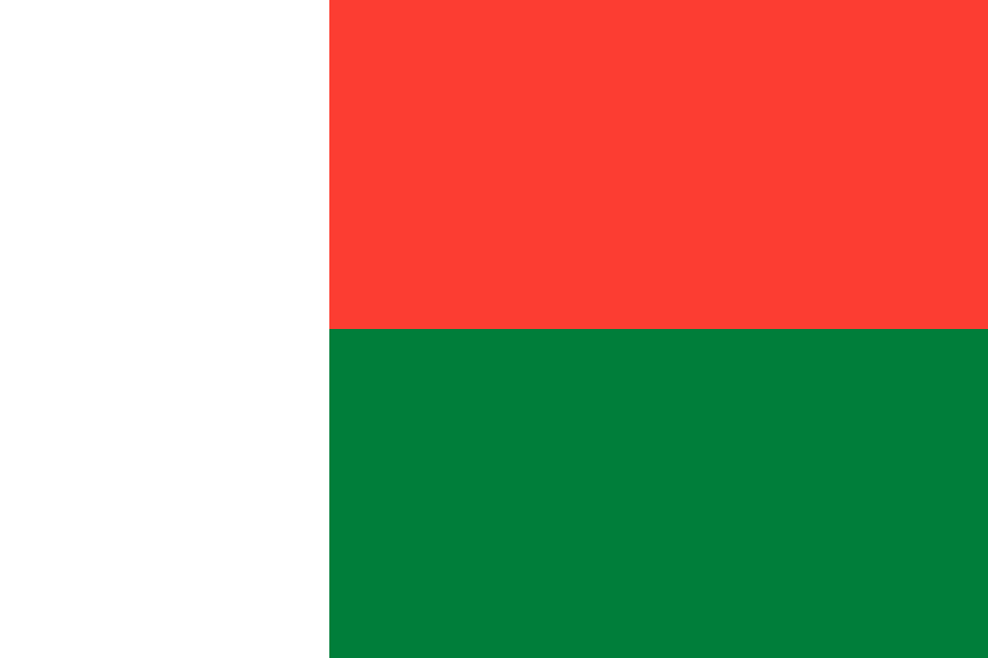
Madagascar at a glance
- Capital
- Antananarivo
- Quiz continent
- Africa
- Languages in reference record
- Malagasy and French
- Currency
- Ariary (MGA)
- Population
- 32,740,678 (2025, World Bank)
- Area
- 587,041 km²
- Coastal setting
- Not landlocked
- ISO codes
- MG / MDG
- Internet country suffix
- .mg
- Highest point
- Maromokotro, 2,876 m
- Seaway to mainland
- Mozambique Canal
- Language Family of Malagasy
- Austronesian
- Short name of the capital
- Tana
- World Heritage Sites
- King's mound Ambohimanga
- Characteristic primates
- Lemurs
Madagascar Flag: Design, Meaning and History
On the mast is a vertical white stripe. To the right of it, the flag is divided horizontally: red above and green below. The two colored fields have the same height; the white extends over the entire flag height. There is neither a coat of arms nor a star, so the unusual division is the most important feature.
The design was adopted in 1958 before independence. The interpretation reproduced in the Factbook archive combines red with sovereignty, green with hope and white with purity. Such assignments of meaning complement the description of form, but do not replace it. For reliable recognition, the combination of white vertical field and red-green horizontal division is first sufficient.
Capital: Antananarivo
Antananarivo is located in the central highlands and is the capital of Madagascar. The frequently used short form Tana is common in everyday life and in travel names. The altitude distinguishes the urban space climatically and scenically from the wet warm coastal regions; Madagascar's capital is therefore not a port city located directly on the sea.
The city name is translated as “City of the Thousand” and associated with a historical fortification and its occupation. In the highlands is also the King's Hill Ambohimanga, UNESCO World Heritage Site since 2001. Together, the capital region and the historical dominion point to the history of political centers in the interior of the island, which is easily overlooked by a pure coastal image.
Practise this capital →Madagascar: Geography, History and Culture
A narrow coastal zone surrounds the higher interior. In the north, the Maromokotro reaches 2,876 meters; central highlands and mountains characterize large parts of the island. The east side is more exposed to the humid air masses of the Indian Ocean, while western and southern areas have much drier conditions. Accordingly, forests, cultivation and water availability differ greatly.
The Mozambique Canal separates Madagascar from the African mainland. The isolated development contributed to the emergence of numerous endemic species that are naturally absent outside the island. Lemurs are a well-known example. However, this relationship does not mean that all habitats have remained the same: agriculture, settlements and forest loss change the conditions for many species and make the conservation of different ecosystems important.
Malagasy belongs to the Austronesian language family and thus points to historical connections across the Indian Ocean. French is another official language and commemorates the colonial period. Madagascar's situation in front of Africa therefore does not only explain its language history. The society arose from various connections between African and Asian spaces, as well as later influences that became differently effective regionally.
Rainforests of Atsinanana
The rainforests became a UNESCO World Heritage site in 2007. They represent wet forest ecosystems whose natural conditions differ significantly from the dry parts of the island.
Dry forests of the West
The World Heritage Entry Andrefana covers dry forest landscapes and was extended in 2023. Together with Atsinanana, he shows why Madagascar’s nature conservation must take into account different habitats.
Ambohimanga
The King's Hill has been a World Heritage Site since 2001. It complements the frequent natural themes with a central place of domination and cultural history in the highlands.
Explore neighbouring and related places
 Algeria
 Angola
 Benin
 Botswana
 Burkina Faso
 Burundi
What did you discover?
Sources and image credits
This English article draws on the institutional sources listed below. Figures and memberships retain their stated reference dates.
Source record: 2 November 2026. A translation does not change the reference date of a figure or membership list.
- github.com/factbook/factbook.json/blob/144d6977b2b01ac1cbd220de754c0a005616760b/africa/ma.json
- data.worldbank.org/indicator/SP.POP.TOTL
- whc.unesco.org/en/statesparties/mg/
- github.com/mledoze/countries