Tunisia Flag, Capital and Country Facts
Tunisia lies between Algeria and Libya on the Central Mediterranean. The north is comparatively wetter, while the land transitions south into dry Sahara and oase spaces. Its red flag with white disc is reminiscent of the Turkish flag. The additional circle is therefore an important detail if the two motifs are to be distinguished.
Test your knowledge →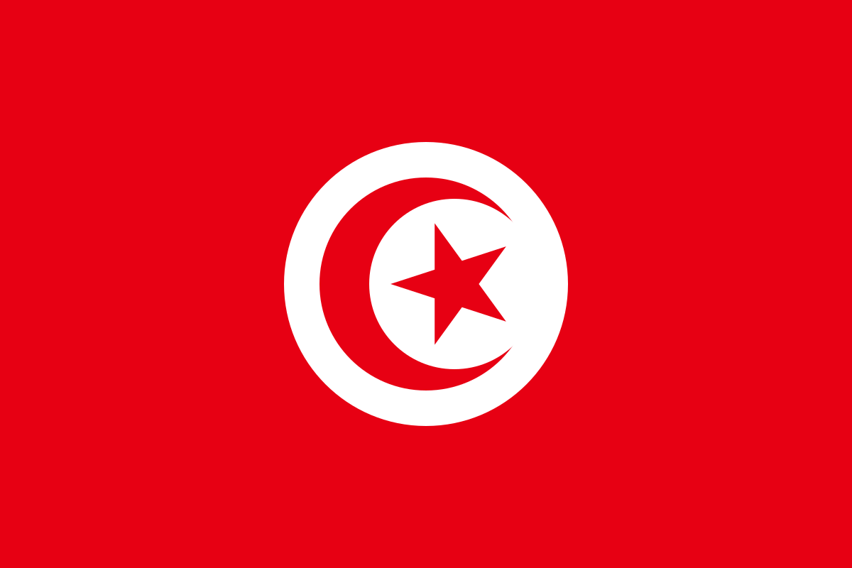
Tunisia at a glance
- Capital
- Tunis
- Quiz continent
- Africa
- Languages in reference record
- Arabic; French is also common
- Currency
- Tunisian Dinar (TND)
- Population
- 12,348,573 (2025, World Bank)
- Area
- 163,610 km²
- Coastal setting
- Not landlocked
- ISO codes
- TN / TUN
- Internet country suffix
- .tn
- Highest mountain
- Jebel Chambi, 1,544 m
- Ancient City of Tunis
- Carthage
- Great amphitheater
- El Jem
- Island
- Djerba
- Natural World Heritage
- Ichkeul National Park
- Independence
- 20 March 1956
Tunisia Flag: Design, Meaning and History
The flag has a red background and a large white disc in the middle. In the disk stand a red crescent moon and a red five-pointed star. So the crescent moon and star are not white like in Turkey. The white circular surface encloses the two signs and is the clearest difference between the related motifs.
The design is linked to Tunisia’s Ottoman history. The crescent moon and star belong to the Islamic symbolic tradition; white is associated with peace. The national motive is older than the independence of France in 1956. The colors should therefore not only be explained from the recent state history, but also from the longer Mediterranean and Ottoman context.
Capital: Tunis
Tunis is located in the northeast near the Gulf of Tunis. The capital with its surroundings forms an important settlement and economic area. Their location in the comparatively densely populated north differs from southern oasis towns. The name of the country and the capital are also connected, although the city and state of course denote different spatial sizes.
The medina of Tunis has been a UNESCO World Heritage site since 1979. Nearby is also the archaeological site of Carthage, also recognized since 1979. Historic Old Town and ancient ruins are not the same ensemble. Their comparison makes different epochs visible and shows how closely several historical focal points lie together in today's capital area.
Practise this capital →Tunisia: Geography, History and Culture
The country includes foothills of the Atlas Mountains, coastal plains, salt sinks and desert landscapes. The Mediterranean Sea characterizes the north and east, while in the south waterholes and oases are of particular importance. The island of Djerba forms another space of its own. Despite its smaller area, Tunisia is thus much more diverse than the simplified idea of a continuous flat sand desert.
Arabic is the official language; the Tunisian variety spoken in everyday life differs from formal High Arabic. French continues to spread through colonial times and educational history. The cultural heritage also refers to Punic, Roman, Islamic and Ottoman connections. These layers are differently visible in different places and should not be combined into a single homogeneous past.
The Amphitheater of El Jem and the ancient city of Dougga are among the well-known Roman sites. Kairouan stands for an important Islamic urban space. The Ichkeul National Park, on the other hand, is a natural world heritage site and shows the importance of wetlands. This last comparison is useful: a state with Saharan areas can also have internationally important water and bird migration landscapes.
White circle as a hint
The white disc distinguishes Tunisia’s flag from Turkey. Within the circle, the crescent moon and star remain red.
Carthage in Tunis
The ancient site is located near the capital and is a UNESCO World Heritage site. It tells a different epoch than the likewise recognized medina.
Ichkeul wetland
Ichkeul belongs to the natural world heritage. It complements the often dominant image of beaches, oases and desert with an important water landscape.
Explore neighbouring and related places
 Algeria
 Libya
What did you discover?
Sources and image credits
This English article draws on the institutional sources listed below. Figures and memberships retain their stated reference dates.
Source record: 2 November 2026. A translation does not change the reference date of a figure or membership list.
- github.com/factbook/factbook.json/blob/144d6977b2b01ac1cbd220de754c0a005616760b/africa/ts.json
- data.worldbank.org/indicator/SP.POP.TOTL
- whc.unesco.org/en/statesparties/tn
- github.com/mledoze/countries