Japan Flag, Capital and Country Facts
Japan forms a long island arc off the east coast of Asia. Mountains occupy a lot of space, while large cities and traffic axes are mainly located in plains and coastal areas. Tokyo is the capital. The white flag with red sun disc is one of the simplest national flags and can therefore be learned well about its exact design.
Test your knowledge →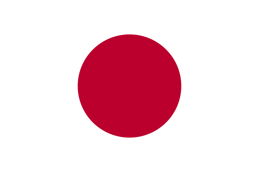
Japan at a glance
- Capital
- Tokyo
- Quiz continent
- Asia
- Languages in reference record
- Japanese (predominant language); among others Ryūkyū languages and Ainu
- Currency
- Yen (JPY)
- Population
- 123,366,734 (2025, World Bank)
- Area
- 377,930 km²
- Coastal setting
- Not landlocked
- ISO codes
- JP / JPN
- Internet country suffix
- .jp, .みんな
- Highest mountain
- Fuji, 3,776 m
- Largest main island
- Honshū
- Former name of Tokyo
- Edo
- Renaming of Tokyo
- 1868
- Flag names
- Hinomaru, “Cycle of the Sun”
- Fuji World Heritage Site
- Since 2013 as a cultural heritage
Japan Flag: Design, Meaning and History
On a white background, a large red circular disc lies exactly in the middle. There are no rays, no writing and no coat of arms. The flag is often called Hinomaru, “circle of the sun”. Bangladesh also shows a red disc, but on a green background and slightly shifted to the hoist side.
The sun has long been a Japanese state symbol. The national flag can be distinguished from other historical or official sun motifs with rays: on the flag shown here are exclusively circle and white field. Mythological stories about the sun goddess Amaterasu belong to tradition and are not a historical dating of the founding of the state.
Capital: Tokyo
Tokyo is located on Honshū in the Kantō plain on a large Pacific Bay. The city was formerly called Edo and in 1868 received the name Tokyo, "Eastern Capital". The name puts it in relation to the further west Kyoto, which previously played a central role as an imperial residence.
The capital is part of a very large contiguous metropolitan area. The metropolitan administration of Tokyo, the central districts and the wider urban region are different spatial terms. Their location on a large plain explains the extent better than the idea that all of Japan consists of densely populated flat surfaces.
Practise this capital →Japan: Geography, History and Culture
The four major islands are called Hokkaidō, Honshū, Shikoku and Kyūshū; numerous smaller islands complement the arch. There are considerable climatic differences between the cooler north and the subtropical southern islands. Many areas are mountainous, so settlements and traffic are concentrated on suitable plains and coastal strips. The island shape alone therefore says little about the available usable space.
Japan is located at active plate boundaries. Earthquakes, tsunamis and volcanism are among the fundamental natural hazards. At 3,776 meters, Fuji is the highest mountain and at the same time a volcano. The close proximity of natural hazards, densely populated spaces and technical infrastructure shapes the handling of the landscape more than a mere list of islands could show.
Japanese is the predominant language; there are also Ryūkyū languages and Ainu. For a long time, writing, religious traditions and architecture were also influenced by contacts with the Asian mainland. UNESCO sites range from ancient capitals and religious buildings to natural areas. Fuji is explicitly registered as a cultural heritage because religious and artistic references are crucial.
Fuji as a cultural heritage
Fuji became a World Heritage Site in 2013 as a “sacred place and source of artistic inspiration”. The entry is a cultural and not a natural world heritage. This shows that even a mountain can be protected because of its importance for faith and art.
Edo and Tokyo
The renaming of Edo to Tokyo took place in 1868. The new name means “Eastern Capital”. This reference also explains why Kyoto and Tokyo have different but interconnected capital roles in the country’s history.
A long island arc
Hokkaidō in the north and the southern islands experience very different climatic conditions. Japan is therefore not an equally warm island nation everywhere. The north-south extension and the many mountains are just as important for geographical orientation as the situation in the Pacific.
Explore neighbouring and related places
 Afghanistan
 Armenia
 Azerbaijan
 Bahrain
 Bangladesh
 Bhutan
Cities and regions in this country
 Osaka
What did you discover?
Sources and image credits
This English article draws on the institutional sources listed below. Figures and memberships retain their stated reference dates.
Source record: 2 November 2026. A translation does not change the reference date of a figure or membership list.
- github.com/factbook/factbook.json/blob/144d6977b2b01ac1cbd220de754c0a005616760b/east-n-southeast-asia/ja.json
- data.worldbank.org/indicator/SP.POP.TOTL
- whc.unesco.org/en/statesparties/jp
- whc.unesco.org/en/list/1418
- github.com/mledoze/countries