Bhutan Flag, Capital and Country Facts
Bhutan is located in the eastern Himalayas between India and China. Narrow valleys, wooded mountain slopes and high peaks determine the inland country. The flag carries a large white dragon, referring to the country name Druk Yul, the land of the Thunder Dragon. For understanding the country, elevation differences are more important than its small map area.
Test your knowledge →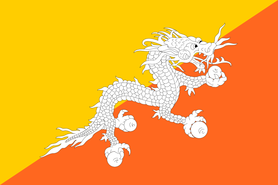
Bhutan at a glance
- Capital
- Thimphu
- Quiz continent
- Asia
- Languages in reference record
- Dzongkha; other regional languages
- Currency
- Ngultrum (BTN)
- Population
- 796,682 (2025, World Bank)
- Area
- 38,394 km²
- Coastal setting
- Landlocked
- ISO codes
- BT / BTN
- Internet country suffix
- .bt
- Traditional country name
- Druk Yul
- Important construction type
- Dzong
- Neighbours
- India and China
- Mountain system
- Himalayas
- National holiday
- 17 December
- Flagfish
- Thunder dragon Druk
Bhutan Flag: Design, Meaning and History
The flag is divided by a diagonal from bottom left to top right into a yellow and an orange triangle. Above the dividing line lies a white dragon with dark contours. His head points to the free flag edge. The animal holds jewels in its claws, so it is a detailed national sign and not just an abstract silhouette.
Yellow is associated with secular rule and orange with Buddhist religious tradition. The white dragon is called Druk; white stands for purity in the traditional explanation. The jewels refer to prosperity. Together, the motif shows the connection between secular and spiritual authority, which also plays an important role in the history and architecture of Bhutan.
Capital: Thimphu
Thimphu is located in a valley in the western part of the country. The capital is the seat of central state institutions and an important urban focus. Their location in the mountains explains why traffic routes follow the valleys and neighboring places on the map are not automatically accessible by short road connections.
A well-known building type are the Dzongs, large fortified structures with religious and administrative functions. The UNESCO country profile lists several such installations, including Punakha, Paro and Trongsa. Thimphu belongs in the same cultural-historical context, while the Dzongs mentioned stand in different places in the country. The capital and cultural heritage must therefore be spatially distinguished.
Practise this capital →Bhutan: Geography, History and Culture
From the subtropical south, the terrain rises to the high mountain ranges of the Himalayas. At short distances, this alternates climate, vegetation and agricultural possibilities. Forests are a defining landscape element. Rivers mainly drain south to the Indian subcontinent, so that Bhutan, despite its high mountains, is hydrologically connected with the deeper landscapes of India.
Dzongkha is the state language, but Bhutan is more linguistically diverse than a single entry suggests. Buddhist religious life characterizes many monasteries and historical facilities. In doing so, signs such as the dragon and concrete religious buildings should be considered together, without reducing all inhabitants to a single cultural form of expression or way of life.
In addition to Dzongs, UNESCO also mentions natural areas such as the Royal Manas and Jigme Dorji National Park as proposals for world heritage. This illustrates the span between subtropical habitats and high mountains. A list of proposals is not yet a World Heritage List. The difference is especially important for Bhutan, whose well-known cultural and natural sites are often combined with UNESCO recognition.
Dragon as a sign of land
Druk is the thunder dragon of the flag. He combines the figurative recognition value with the traditional country name Druk Yul.
Dzongs with dual function
Several dzongs are proposed as centers of secular and religious authority. This connection matches the two background colors of the flag.
High altitude
Bhutan includes warm southern valleys and high alpine areas. The land border alone explains the landscape less well than a look at heights and river systems.
Explore neighbouring and related places
 China
 India
What did you discover?
Sources and image credits
This English article draws on the institutional sources listed below. Figures and memberships retain their stated reference dates.
Source record: 2 November 2026. A translation does not change the reference date of a figure or membership list.
- github.com/factbook/factbook.json/blob/144d6977b2b01ac1cbd220de754c0a005616760b/south-asia/bt.json
- data.worldbank.org/indicator/SP.POP.TOTL
- whc.unesco.org/en/statesparties/bt
- github.com/mledoze/countries