Osaka: City Flag, History and Identity
Osaka is a commercial city whose identity is closely linked to waterways and bridges. Rivers, canals and port traffic helped develop their economy. The yellow Miotsukushi on the city flag picks up this story: it goes back to an old sign that indicated a navigable passage in shallow water.
Test your knowledge →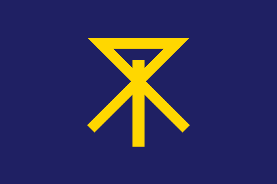
Osaka at a glance
- Name
- Osaka
- Country
- Japan
- Profile type
- City
- Island
- Honshū
- Prefecture
- Osaka; distinguishable from the city
- River basins of urban development
- Estuaries of Yodo and Yamato
- Modern City Status
- 1 April 1889
- Emblem selection
- Miotsukushi since 1894
- Island in the center
- Nakanoshima
- Rivers around Nakanoshima
- Dōjima and Tosabori
- Urban flowers
- Cherry blossom and stepmother; elected in 1987
The Flag of Osaka
On the violet blue cloth is a yellow geometric sign. Its vertical line, oblique legs and upper triangular shape form the Miotsukushi. The selected city flag does not contain an advertised place designation and no additional coat of arms sign; the striking sign alone bears the recognition of the city.
The city chose the Miotsukushi as its emblem in 1894. Historical examples of such sea signs stood in the shallow waters of the Bay of Naniwa. Their forms changed over time. The urban explanation therefore connects the sign with shipping and economic prosperity, without claiming an unchanged age-old chart.
Osaka: Location and Territorial Role
Osaka is located on Honshū in the western part of Japan and belongs to the prefecture of the same name. The city and the prefecture are different administrative units. The city developed in the area of the estuaries of Yodo and Yamato. Numerous watercourses structure the urban area and explain why the expression water city has a concrete geographical basis here.
Several different rooms help to understand the center. Nakanoshima is located as an island between Dōjima and Tosabori. Dōtonbori, on the other hand, belongs to the lively southern amusement and shopping area of Minami. The castle with its trenches forms another focus. These places stand for administration and culture, entertainment and historical domination.
Landscape, History and Culture
Osaka’s bridges were far more than necessary transitions. Many were financed and maintained by merchants and residents during the Edo period. The phrase of the 808 bridges of Naniwa describes their large number graphically. It should not be understood as accurate bridging statistics, but as an expression of a water-rich trading city.
The modern commune received its city status on 1 April 1889. Initially, the prefectural governor also held the office of mayor before a more independent city administration developed. Such details help to separate the long settlement history from the younger municipal legal form. The city age can therefore not only be read from the founding date of today's administration.
Dōtonbori combines gastronomy, eye-catching advertising and a long entertainment tradition. The name is reminiscent of Yasui Dōton, who started the construction of the canal in the early seventeenth century. Theatres and tea houses later shaped the quarter. Today’s promenades on the water make visible how a historical transport area has become a public lounge.
Nakanoshima
The island between Dōjima and Tosabori is a particularly vivid part of the water city. The park and central public meeting hall combine free space with representative architecture. If you look at both banks here, you immediately realize that river arms run not only on the edge, but in the middle of the center of Osaka.
Dōtonbori’
Large signs, restaurants and the proximity to the canal characterize Dōtonbori. The history of the district includes theaters and other entertainment offerings; it is therefore more than a collection of neon signs. The path on the water offers an additional perspective on the same urban space, which looks very different from the business streets.
Burgparkpark
The trenches around the castle bring together historical fortifications and aquatic landscape. The park is also known for its cherry blossom. As a green space, it differs significantly from the densely built entertainment district. Together, both places show how differently water is used and perceived in today’s cityscape.
Explore this country and nearby profiles
 Japan
What did you discover?
Take this flag into the quiz
Sources and image credits
This English article draws on the institutional sources listed below. Figures and memberships retain their stated reference dates.
Source record: 2 November 2026. A translation does not change the reference date of a figure or membership list.
- city.osaka.lg.jp/contents/wdu020/enjoy/en/overview/content_CityProfile.html
- suito-osaka.jp/en/tourism/
- osaka-info.jp/spot/dotonbori/
- commons.wikimedia.org/wiki/File%3AFlag_of_Osaka%2C_Osaka.svg