Jamaica Flag, Capital and Country Facts
Jamaica is located south of Cuba in the Caribbean Sea. Coastal plains, karst landscapes and the Blue Mountains characterize the island, which has a cultural impact far beyond its size. Its flag stands out through a golden diagonal cross. Kingston combines a protected harbour space with the history of trade, music and social change.
Test your knowledge →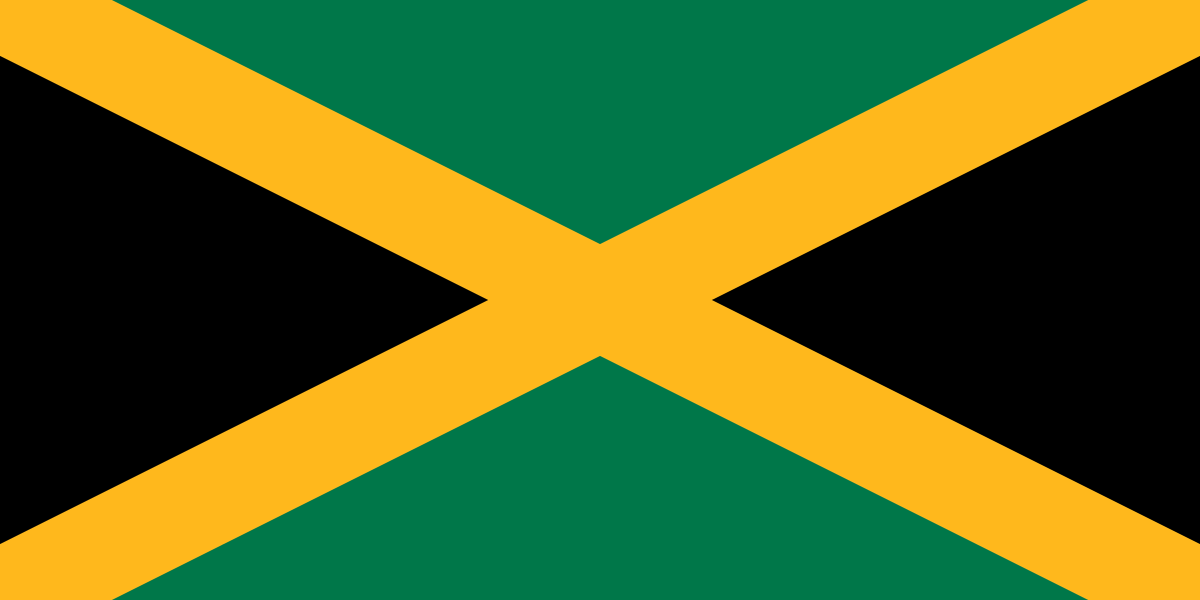
Jamaica at a glance
- Capital
- Kingston
- Quiz continent
- North America
- Languages in reference record
- English; Jamaica Creole spread in everyday life
- Currency
- Jamaica Dollar (JMD)
- Population
- 2,837,077 (2025, World Bank)
- Area
- 10,991 km²
- Coastal setting
- Not landlocked
- ISO codes
- JM / JAM
- Internet country suffix
- .jm
- Highest mountain
- Blue Mountain Peak, 2,256 m
- Independence
- 6 August 1962
- Historical port location
- Port Royale
- Mountains in the east
- Blue Mountains
- Important raw material
- bauxite
- Marine space
- Caribbean Sea
Jamaica Flag: Design, Meaning and History
A golden diagonal cross divides the flag into four triangles. Above and below the surfaces are green, on the poles and flight sides black. The cross is not an upright Nordic cross, but a St. Andrew’s cross. The flag does not use red, blue or white and is therefore very different from many other national flags.
The design was introduced for independence in 1962. Green stands for hope and agricultural or plant resources, gold for sunlight and natural riches. The interpretation of black has been formulated differently over time, among other things as strength over difficulties. Such historical interpretations should not be equated with rigid characteristics of all people.
Capital: Kingston
Kingston is located on the southeast coast off the Blue Mountains. The large natural harbour explains the economic importance of the site. The town was built after the severe earthquake that destroyed Port Royal in 1692. The capital and former port town are therefore located in a common coastal area, but are not the same historical settlement core.
The port connected Jamaica with Atlantic trade networks; the city also developed important music and cultural scenes. Reggae is particularly well known internationally, but Kingston cannot be reduced to a single style or artist. The city’s history also includes colonial rule, enslavement, trade and the political struggles on the road to independence.
Practise this capital →Jamaica: Geography, History and Culture
The Blue Mountains reach 2,256 meters to the east. High altitudes influence precipitation and cultivation; coffee from the mountains therefore has a different geographical background than coastal agriculture. Further west, Karst is characterised by difficult-to-access hillside landscapes. The island is therefore neither continuously flat nor uniformly wet everywhere. The coastal plains are often narrow and interrupted. A round trip along the sea therefore conveys a different geography than the view of the central mountains and the hard-to-access karst areas.
English is an official language; Jamaica Creole plays an important role in everyday life and in cultural expressions. The history of the population is closely linked to colonial plantation farming and African diaspora. This resulted in new linguistic and musical forms. The diversity of these developments should not be described as a uniform lifestyle for all Jamaicans.
Jamaica became independent from the United Kingdom in 1962. The factbook archive stand of 2025 mentions tourism, bauxite or aluminium industry and other services as important economic sectors. Between mineral raw materials, mountain landscapes and beaches, there are different usage interests. The UNESCO heritage of the Blue and John Crow Mountains in turn combines natural values with the history of resistant Maroon communities.
Blue and John Crow Mountains
The mountain is a mixed UNESCO World Heritage site. Its significance includes nature and the history of the Maroons who eluded enslavement.
Port Royale
The 17th-century archaeological ensemble of the Port Royal became a World Heritage Site in 2025. It complements the mountain region with a maritime historical site.
Golden Cross
Jamaica’s flag is particularly easy to recognize due to its color and surface arrangement. The black triangles lie laterally, the green ones above and below.
Explore neighbouring and related places
 Antigua & Barbuda
 Bahamas
 Barbados
 Belize
 Canada
 Costa Rica
What did you discover?
Sources and image credits
This English article draws on the institutional sources listed below. Figures and memberships retain their stated reference dates.
Source record: 2 November 2026. A translation does not change the reference date of a figure or membership list.
- github.com/factbook/factbook.json/blob/144d6977b2b01ac1cbd220de754c0a005616760b/central-america-n-caribbean/jm.json
- data.worldbank.org/indicator/SP.POP.TOTL
- whc.unesco.org/en/statesparties/jm
- github.com/mledoze/countries