Iraq Flag, Capital and Country Facts
Iraq encompasses large parts of the historic metropolitan area between the Tigris and Euphrates. In the north are mountains, in the south marshes and a short access to the Persian Gulf. Baghdad is located on the Tigris. The red-white-black flag can be clearly distinguished from similar Arabic tricolors on the green Arabic script in its middle strip.
Test your knowledge →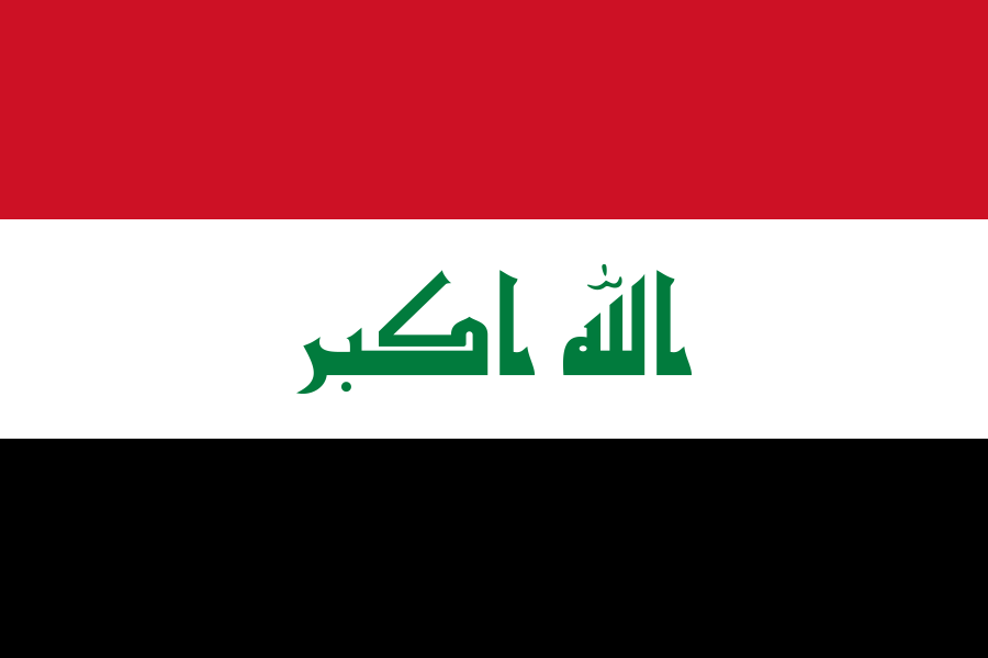
Iraq at a glance
- Capital
- Baghdad
- Quiz continent
- Asia
- Languages in reference record
- Arabic and Kurdish (official languages); other languages used regionally
- Currency
- Iraqi Dinar (IQD)
- Population
- 47,020,774 (2025, World Bank)
- Area
- 438,317 km²
- Coastal setting
- Not landlocked
- ISO codes
- IQ / IRQ
- Internet country suffix
- .iq
- Large rivers
- Euphrates and Tigris
- Gulf access
- Persian Gulf
- River in Baghdad
- Tigris
- World Heritage of Babylon
- Registered 2019
- World Heritage Erbil
- Citadel, registered in 2014
- Independence Day
- October 3, reference to 1932
Iraq Flag: Design, Meaning and History
Three horizontal stripes of equal height lie on top of each other in red, white and black. In the white stripe is written in green Arabic script the Takbir “Allahu akbar”. The flag has no stars. The script is therefore the most important distinguishing feature of the similarly divided Yemeni flag, whose middle strip remains empty.
The colors are in the tradition of Arab liberation flags. The design with today's lettering without stars was adopted in 2008. When comparing with other states, caution is necessary: The archived factbook describes an older flag in Syria. For Iraq, the visible features of writing, green and the order red-white-black remain crucial.
Capital: Baghdad
Baghdad is located on the Tigris in the central river lowlands. The city became the capital of the Abbasids in the 8th century and developed into an important center of trade and knowledge. This historical role explains its notoriety far beyond the borders of today’s Iraqi state.
The location on the river connects Baghdad with the core region of Mesopotamia. It distinguishes the capital of Basra in the southern river and gulf area or the high-altitude cities of the north. The country name Iraq and the ancient name Mesopotamia are not completely congruent geographical terms: historical cultural areas followed different borders than modern states.
Practise this capital →Iraq: Geography, History and Culture
Euphrates and Tigris dominate vast plains and flow over the Shatt al-Arab into the Persian Gulf. In the west there are dry desert areas, in the north mountains. The short Gulf Coast shows that although Iraq has a sea access, it is mainly spatially determined by inland landscapes and rivers. Water availability is fundamental for agriculture and settlements.
Arabic and Kurdish are official languages. Other communities use Turkmen and Neo-Aramaic languages, among others. This linguistic diversity reflects a long history of different populations and empires. It should not be reduced to a single religion or a single regional identity. Especially the mountainous north and the southern river plains have different historical references.
The area includes significant centers of early urban societies such as Babylon and Assur. Its archaeological sites reveal a history well before the emergence of modern Iraq. Other World Heritage sites belong to Islamic eras. The UNESCO list thus juxtaposes several layers of time and complements the image of the country, which is often limited to recent wars, with concrete cultural and landscape history.
Babylon
Babylon was added to the UNESCO World Heritage List in 2019. The site is a central point of reference in the history of Mesopotamia. It stands alongside other temporally and culturally diverse Iraqi World Heritage sites such as Assur, Hatra and Samarra.
The Ahwar
The Ahwar in southern Iraq are listed as a mixed natural and cultural heritage. The entry connects marsh landscapes with the remains of Mesopotamian cities. It makes it particularly clear that waters and human settlement history cannot be meaningfully separated here.
Erbil's Citadel
The Erbil Citadel has been a World Heritage Site since 2014. It is located in the north of the country and draws attention beyond Baghdad and the southern plains. Iraq's historical heritage is thus spread over several very different regions.
Explore neighbouring and related places
 Iran
 Jordan
 Kuwait
 Saudi Arabia
 Syria
 Türkiye
What did you discover?
Sources and image credits
This English article draws on the institutional sources listed below. Figures and memberships retain their stated reference dates.
Source record: 2 November 2026. A translation does not change the reference date of a figure or membership list.
- github.com/factbook/factbook.json/blob/144d6977b2b01ac1cbd220de754c0a005616760b/middle-east/iz.json
- data.worldbank.org/indicator/SP.POP.TOTL
- whc.unesco.org/en/statesparties/iq
- github.com/mledoze/countries