Pakistan Flag, Capital and Country Facts
Pakistan connects the coast of the Arabian Sea with the Indu Valley and very high mountains in the north. Islamabad is a planned capital; Karachi, on the other hand, is a major port and economic metropolis. The green flag with a white crescent, star and mast stripe refers to the Islamic state and the role of religious minorities.
Test your knowledge →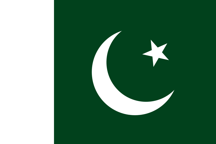
Pakistan at a glance
- Capital
- Islamabad
- Quiz continent
- Asia
- Languages in reference record
- Urdu (national language), English for official purposes, including Punjabi, Sindhi, Pashto and Baloch
- Currency
- Pakistani Rupee (PKR)
- Population
- 255,219,554 (2025, World Bank)
- Area
- 881,912 km²
- Coastal setting
- Not landlocked
- ISO codes
- PK / PAK
- Internet country suffix
- .pk
- Highest mountain
- K2, 8,611 m
- Large river
- Indus
- Marine space
- Arabian Sea
- Independence
- 14 August 1947
- National language
- Urdu
- Pakistan Day
- 23 March
Pakistan Flag: Design, Meaning and History
A dark green field carries a white crescent moon and a white five-pointed star. On the hoist side stands a vertical white strip. This bright edge is an important note: the flag is not just a green rectangle with Islamic symbols, but has a clearly set white zone.
The Factbook Archive assigns green, crescent and star to the Islamic symbolic tradition. The white stripe stands for religious minorities. The design thus combines the religious reference of the founding of the state with an explicitly visible further part of the population. For the quiz, the crescent moon and star should be considered together with the vertical white surface.
Capital: Islamabad
Islamabad is located in the north of the country on the edge of Margalla hills. The city was planned as a new capital and replaced Karachi, further south on the coast. The name means “City of Islam” and connects an Arabic term with the Persian place-name broadcast –abad.
The neighboring Rawalpindi has been an older city location and temporary transitional seat of state duties. Islamabad and Rawalpindi therefore form a closely connected, but not identical space. The new capital is not equated with Karachi or the culturally-historically important Lahore; these cities perform other central functions in the country.
Practise this capital →Pakistan: Geography, History and Culture
The fertile Indu Valley forms a main axis between the northern inland and the Arabian Sea. To the west are dry plateaus and mountains, in the north meet large high mountain systems. The K2 reaches 8,611 meters. On the same map, coastal lowlands and extreme high mountains appear; a single climate label would be inadequate for this span.
Urdu serves as a national language and interregional language of communication, while English plays an important role for official purposes. Punjabi, Sindhi, Pashto, Baloch and other languages characterize large regions. The public position of a language therefore does not mean that it is the first language for most people. Pakistan in particular makes the distinction between everyday linguistic life and state function clear.
Pakistan was formed in 1947 during the division of British India. The former eastern part of the country became independent in 1971 as Bangladesh. At the same time, the history of today’s state goes back much further: Mohenjo-Daro documents the Indus culture and Taxila documents the Buddhist past. Modern state foundation and ancient cultural history should therefore be explained as different time levels.
Mohenjo-Daro
The archaeological ruins of Mohenjo-Daro became a UNESCO World Heritage site in 1980. They belong to the history of the Indus culture and trace back several millennia before the modern founding of the state. The site shows the importance of early cities in the space of today's Pakistan.
Taxila
Taxila has also been on the World Heritage List since 1980. The place is an important reference point in the Buddhist history of the region. This past complements today’s Islamic state profile with a concrete older cultural layer.
Lahores Monuments
The fortress and Shalimar Gardens of Lahore have been a World Heritage Site since 1981. They represent the history of the Mughal period. The site is located in a historical city other than Islamabad and underlines that political capital and cultural centers do not have to be identical.
Explore neighbouring and related places
 Afghanistan
 China
 India
 Iran
What did you discover?
Sources and image credits
This English article draws on the institutional sources listed below. Figures and memberships retain their stated reference dates.
Source record: 2 November 2026. A translation does not change the reference date of a figure or membership list.
- github.com/factbook/factbook.json/blob/144d6977b2b01ac1cbd220de754c0a005616760b/south-asia/pk.json
- data.worldbank.org/indicator/SP.POP.TOTL
- whc.unesco.org/en/statesparties/pk
- github.com/mledoze/countries