Comoros Flag, Capital and Country Facts
The Comoros is located in the Indian Ocean between the East African coast and Madagascar. The island nation comprises three major inhabited main islands. Nevertheless, four stripes and four stars appear on the flag because the national symbolism also includes the claim to Mayotte. Geographical archipelago, territory and political aspirations must be distinguished here.
Test your knowledge →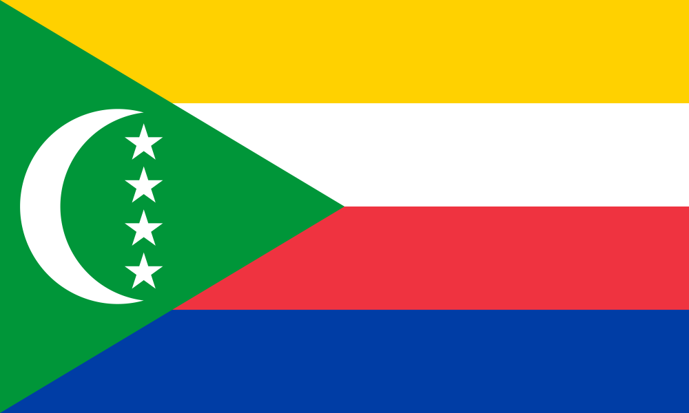
Comoros at a glance
- Capital
- Moroni
- Quiz continent
- Africa
- Languages in reference record
- Comorian (Shikomori), Arabic and French
- Currency
- Comoros franc (KMF)
- Population
- 882,847 (2025, World Bank)
- Area
- 1,862 km²
- Coastal setting
- Not landlocked
- ISO codes
- KM / COM
- Internet country suffix
- .km
- Largest island
- Grande Comore / Ngazidja
- Other main island
- Anjouan / Ndzuwani
- Smaller main island
- Mohéli/Mwali
- Highest mountain
- Karthala, approximately 2,360 m
- Marine space
- Northern Mozambique Canal
- Independence
- 6 July 1975
Comoros Flag: Design, Meaning and History
Four equally wide horizontal stripes point from top to bottom yellow, white, red and blue. On the left is a green triangle with a white crescent moon and four white five-pointed stars. The stars are perpendicular between the tips of the crescent. The contrast between the four stripes and the green triangle makes the flag particularly colorful.
The four stripes and four stars refer to the four main islands of the archipelago: Grande Comore, Mohéli, Anjouan and Mayotte. However, Mayotte is administered by France and does not belong to the effectively administered territory of the Union of the Comoros. Green and crescent are in Islamic symbolic tradition. The flag thus also represents a political idea.
Capital: Moroni
Moroni is located on the west coast of Grande Comore, whose Comorian name is Ngazidja. The capital is a political and economic focus on the largest island. The volcano Karthala characterizes the island far beyond the urban area. In an island state, the capital city location, port and connections to the other islands are closely linked.
The city belongs to the history of the coastal settlements of the western Indian Ocean. Arab, African and later European contacts are essential for this area. Since 2026, the UNESCO Country Profile has been a World Heritage Site for the Medinas of the Historic Sultanates. This entry illustrates that the cultural history of the archipelago does not begin with the European colonial period.
Practise this capital →Comoros: Geography, History and Culture
The islands are of volcanic origin and are located at the northern entrance of the Mozambique Canal. Grande Comore has an active volcano with the Karthala. Mohéli and Anjouan each have their own relief and coastal forms. Separation by the sea means that short distances on the map do not allow for the same everyday connections as on a contiguous land area.
Comorian belongs to the linguistic environment of Swahili and has different island variants. Arabic and French have additional religious, historical and public functions. The situation between Africa and Madagascar explains the contacts, without it being possible to derive a single line of origin for the entire population. Island-related identities and common state affiliation coexist.
The cultivation of fragrance and spice plants, including ylang-ylang, is one of the well-known economic characteristics. The UNESCO profile lists the cultural landscape of perfume plantations on the proposal list. Similarly, marine ecosystems and protected areas are important issues. Inscribed cultural heritage, other proposals and nature reserves are different categories and should not be mixed together in a country portrait.
Four symbols, three main islands
The state administration includes Grande Comore, Mohéli and Anjouan. The fourth star and stripe symbol refers to Mayotte and the Comorian claim.
Karthala on Grande Comore
The volcano is a central landscape feature of the main island. It shows the volcanic origin of the archipelago particularly clearly.
Medinas of the Sultanates
UNESCO has listed the historical medinas as a World Heritage Site since 2026. They complement the image of the country, which is often limited to nature and island holidays.
Explore neighbouring and related places
 Algeria
 Angola
 Benin
 Botswana
 Burkina Faso
 Burundi
What did you discover?
Sources and image credits
This English article draws on the institutional sources listed below. Figures and memberships retain their stated reference dates.
Source record: 2 November 2026. A translation does not change the reference date of a figure or membership list.
- github.com/factbook/factbook.json/blob/144d6977b2b01ac1cbd220de754c0a005616760b/africa/cn.json
- data.worldbank.org/indicator/SP.POP.TOTL
- whc.unesco.org/en/statesparties/km
- github.com/mledoze/countries