Cameroon Flag, Capital and Country Facts
Cameroon extends from the Atlantic coast over rainforests and highlands to the drier landscapes near Lake Chad. This large north-south span shapes climate and languages. The flag combines pan-African colors with a single star. While Yaoundé is the political centre, Douala is closely linked to port economy and trade.
Test your knowledge →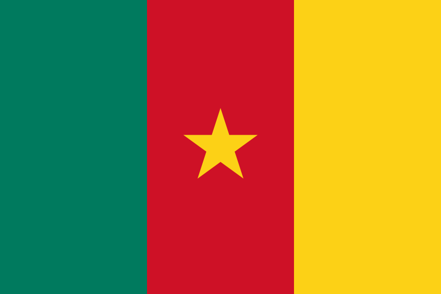
Cameroon at a glance
- Capital
- Yaoundé
- Quiz continent
- Africa
- Languages in reference record
- French and English; numerous other national languages
- Currency
- Central African CFA franc (XAF)
- Population
- 29,879,337 (2025, World Bank)
- Area
- 475,442 km²
- Coastal setting
- Not landlocked
- ISO codes
- CM / CMR
- Internet country suffix
- .cm
- Highest volcano
- Cameroon mountain, Fako summit; archive value 4.045 m
- National holiday
- 20 May
- Large port
- Douala
- Northern border waters
- Lake Chad
- Independence of the French-administered territory
- 1 January 1960
- Cross-border World Heritage
- Sangha Trinational
Cameroon Flag: Design, Meaning and History
The flag consists of three equally wide vertical stripes in green, red and yellow. In the middle of the red stripe stands a yellow five-pointed star. It is worth paying attention to its position: Senegal also uses vertical pan-African colors, but has a different arrangement and a green star.
Green is assigned to the forests of the south, yellow to the sun and savannahs of the north. Red and the middle star stand for unity. The current one-star design followed in 1975 on earlier variants. The common symbolism was intended to overcome separate historical administrative traditions; it does not mean that regional differences have disappeared.
Capital: Yaoundé
Yaoundé is located in the hilly interior. As a capital, it concentrates state institutions and administration. The location differs significantly from Douala on the coast, the main economic port space. Cameroon’s two well-known cities are therefore well remembered by their functions: Yaoundé for the political capital, Douala for the maritime trade.
The development of Yaoundé is connected with the German colonial period; the city name goes back to the local Ewondo population. Later, French administrative influences were added. This story explains a part of today's language landscape, but must not displace the much older local societies and names from the representation.
Practise this capital →Cameroon: Geography, History and Culture
In the southwest, the active Cameroon mountain volcano rises immediately near the sea. Its location shows the strong elevation: from hot-humid coast, the terrain can rise at a short distance to cooler altitudes. In the north, on the other hand, highlands pass into savannahs and drier areas. The northern area belongs to the catchment area of Lake Chad, while southwestern rivers lead to the Atlantic Ocean. The state thus connects coastal regions and drainless or inland African water landscapes, which additionally illustrates the climatic and ecological diversity.
French and English are official languages. Their spread is related to the division of the former German colonial territory after the First World War. In addition, numerous African languages are spoken. The two European official languages are therefore a level of understanding and administration, not a complete list of linguistic reality.
The state status of 2025, archived in the Factbook, describes agriculture, oil and other raw materials as parts of the economic structure. The juxtaposition of different landscapes enables different cultivation forms. Likewise, the natural and cultural heritage is spread over several regions: Protected rainforests in the south and the cultural landscape of the Mandara mountains in the north tell very different stories.
Dja
The Dja Faunenreservat is on the UNESCO World Heritage List. It protects a significant section of the Central African rainforest landscape.
Sangha Trinational
This World Heritage Site is shared with the Central African Republic and the Republic of Congo. Forest protection here follows interconnected habitats across political boundaries.
Mandara mountains
The Diy-Gid-Biy cultural landscape was added to the World Heritage List in 2025. It complements the rainforest sites with a cultural monument of the northern mountains.
Explore neighbouring and related places
 Central African Republic
 Chad
 Republic of the Congo
 Equatorial Guinea
 Gabon
 Nigeria
What did you discover?
Sources and image credits
This English article draws on the institutional sources listed below. Figures and memberships retain their stated reference dates.
Source record: 2 November 2026. A translation does not change the reference date of a figure or membership list.
- github.com/factbook/factbook.json/blob/144d6977b2b01ac1cbd220de754c0a005616760b/africa/cm.json
- data.worldbank.org/indicator/SP.POP.TOTL
- whc.unesco.org/en/statesparties/cm
- github.com/mledoze/countries