Nigeria Flag, Capital and Country Facts
Nigeria is located on the Gulf of Guinea and ranges from the humid coastal area to dry northern landscapes. Abuja is the capital, Lagos the former capital and an important port metropolis. Niger and Benue connect large parts of the countryside. The green-white-green flag is simple; however, the linguistic and cultural diversity of the country is exceptionally large.
Test your knowledge →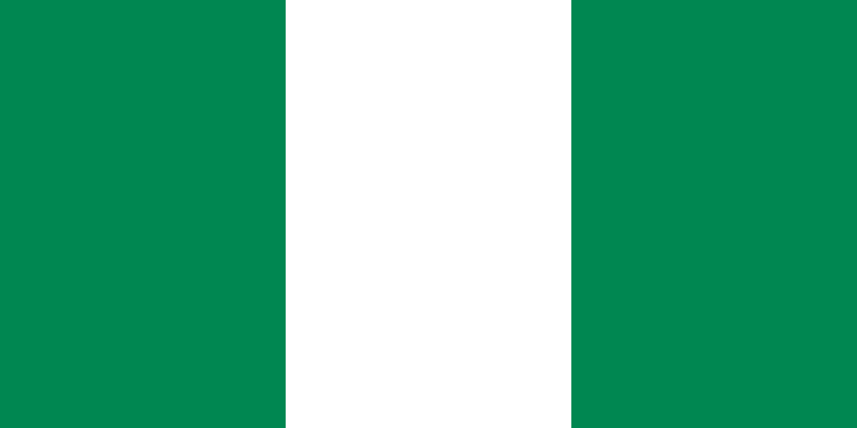
Nigeria at a glance
- Capital
- Abuja
- Quiz continent
- Africa
- Languages in reference record
- English (official); among others Hausa, Yoruba, Igbo and Fulfulde
- Currency
- Naira (NGN)
- Population
- 237,527,782 (2025, World Bank)
- Area
- 923,768 km²
- Coastal setting
- Not landlocked
- ISO codes
- NG / NGA
- Internet country suffix
- .ng
- Independence
- 1 October 1960
- Former capital
- Lagos
- Capital change
- 1991
- Large rivers
- Niger and Benue
- Collapse
- by Lokoja
- Highest point
- Chappal Waddi, 2,419 m according to Factbook Archive
Nigeria Flag: Design, Meaning and History
Three equally wide vertical stripes are in green, white and green. The flag has no coat of arms and no star. Because the two outer fields are the same, it is symmetrical to the left and right. The vertical division is important to distinguish them from green flags with white cross stripes.
The Factbook Archive combines green with forests and natural resources, white with peace and unity. The design dates back to the time of independence in 1960. It thus relies on a few colors and large areas instead of a detailed coat of arms. In the quiz picture, the combination of two green outer stripes and white center is sufficient for a secure assignment.
Capital: Abuja
Abuja is located in the central interior and was planned as a new capital. In 1991 she took over the function of Lagos. The move created a political center outside the major coastal metropolis and is therefore an essential part of the geographical understanding of Nigeria.
Lagos remains an important economic and port area on the Atlantic. Anyone who calls it a capital city reverts to an earlier order. Rather, Abuja and Lagos show the separation between a political capital and a very large economic metropolis. The name Abuja comes from an older place in the region, which today is called Suleja.
Practise this capital →Nigeria: Geography, History and Culture
In the south are coastal plains, lagoons and the vast Niger Delta. To the north follow savannahs and drier landscapes to the area of Lake Chad. Niger and Benue unite inland before the Niger flows to the Gulf of Guinea. The river system thus provides a geographical link between inland areas and coast.
English serves as an official language, while Hausa, Yoruba, Igbo and Fulfulde are of great importance. There are also many other languages. This diversity cannot be meaningfully reduced to three population groups. Regional historical connections also differ: northern empires and trade networks, southwestern cities and the southeastern river and coastal area belong to different historical areas.
Nigeria became independent from the United Kingdom on 1 October 1960. Southern oil is one of the economic foundations described in the Factbook archive; at the same time, agriculture, services and large urban markets play important roles. Oil wealth does not explain the country alone. Environmental impacts in the delta and regional differences should be considered separately from blanket statements about the total population.
Sukur
The cultural landscape of Sukur has been a UNESCO World Heritage Site since 1999. It is located in the northeastern inland and draws attention to historical landscape use beyond the large coastal cities. Nigeria thus has a world heritage that does not emerge from a colonial port or capital history.
Osun-Osogbo
The sacred grove of Osun-Osogbo was added to the World Heritage List in 2005. It documents a religiously and culturally significant landscape. Together with Sukur, he shows how different the historical spaces can be within a single state.
Niger and Benue
The two rivers unite at Lokoja. Its confluence is an important card point inland. From there, the Niger continues to the delta, so that the transition from inland to coastal area can be traced on a contiguous body of water.
Explore neighbouring and related places
 Benin
 Cameroon
 Chad
 Niger
What did you discover?
Sources and image credits
This English article draws on the institutional sources listed below. Figures and memberships retain their stated reference dates.
Source record: 2 November 2026. A translation does not change the reference date of a figure or membership list.
- github.com/factbook/factbook.json/blob/144d6977b2b01ac1cbd220de754c0a005616760b/africa/ni.json
- data.worldbank.org/indicator/SP.POP.TOTL
- whc.unesco.org/en/statesparties/ng
- github.com/mledoze/countries