Cape Verde Flag, Capital and Country Facts
Cape Verde, internationally known as Cabo Verde, is an island nation in the Atlantic Ocean off West Africa. Its volcanic islands have very different heights and landscapes: some are mountainous, others comparatively flat and dry. The capital Praia is located on Santiago. The name of the state and the blue flag therefore lead to a country whose spatial connection is mainly due to the sea.
Test your knowledge →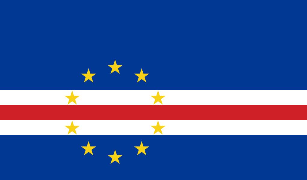
Cape Verde at a glance
- Capital
- Praia
- Quiz continent
- Africa
- Languages in reference record
- Portuguese as an official language; Cape Verde Creole in several island variants
- Currency
- Cape Verde-Escudo (CVE)
- Population
- 527,326 (2025, World Bank)
- Area
- 4,033 km²
- Coastal setting
- Not landlocked
- ISO codes
- CV / CPV
- Internet country suffix
- .cv
- Highest mountain
- Pico do Fogo, 2,829 m
- Independence
- 5 July 1975
- National holiday
- 5 July
- Capital Islands
- Santiago
- Main Islands
- Ten
- Historical place name
- Ribeira Grande for Cidade Velha
Cape Verde Flag: Design, Meaning and History
The flag shows a large blue background, which is traversed below the center by a white-red-white stripe. To the left of the center is a ring of ten yellow five-pointed stars. The stripes do not form five equally wide color fields: the upper blue field is significantly higher than the lower one.
The ten stars represent the ten main islands of the archipelago. Blue is associated with sea and sky, white with peace and red with the common construction of the country. This design, which has been used since 1992, is fundamentally different from the former flag, which was more closely linked to the joint anti-colonial project with Guinea-Bissau.
Capital: Praia
Praia is located on the south coast of Santiago, the largest island in the state. The name means “beach” in Portuguese, but the capital is more than a coastal town: it bundles national administration, port functions and economic services. Its older city centre, located on a plateau, is an important reference point in urban geography.
West of Praia lies Cidade Velha, formerly called Ribeira Grande. This historic settlement was an early colonial hub, but is not the current capital. Its old town has been on the UNESCO World Heritage List since 2009. The comparison shows how political centers can shift while an older place retains its historical significance.
Practise this capital →Cape Verde: Geography, History and Culture
The islands are of volcanic origin and belong to the Atlantic island region of Macaronesia. The Pico do Fogo reaches 2,829 meters and rises on the island of the same name. Mountain relief affects precipitation and settlement possibilities. Within a small island state, significant differences between dry coastal sections and higher-lying landscapes arise.
The islands became part of the Portuguese colonial network in the Atlantic; slave trade and plantation farming belong to the history of Ribeira Grande. In 1975, Cape Verde became independent. Portuguese remained an official language, while Cape Verde Creole languages are particularly important for everyday life and cultural expressions. The distinction between official and everyday language describes the country more accurately than a single language.
Water scarcity and fluctuating rain limit agriculture. Transport links between the islands and the large diaspora are therefore just as important topics as tourism and fishing. The scattered location makes some services more difficult, but opens up connections along Atlantic routes. The sea area between the islands is thus not a mere interspace, but part of the economic and social connection.
Cidade Velha,
The historic center of Ribeira Grande became a World Heritage Site in 2009. Church ruins, streets and fortifications are reminiscent of early Portuguese expansion and the Atlantic slave trade.
Volcanic island of Fogo
The highest mountain in the country is also a volcano. Its height is in stark contrast to the flatter islands of the archipelago.
Santiago as a center
In Santiago are both Praia and Cidade Velha. The current capital and the historical colonial place are nevertheless two different settlements.
Explore neighbouring and related places
 Algeria
 Angola
 Benin
 Botswana
 Burkina Faso
 Burundi
What did you discover?
Sources and image credits
This English article draws on the institutional sources listed below. Figures and memberships retain their stated reference dates.
Source record: 2 November 2026. A translation does not change the reference date of a figure or membership list.
- github.com/factbook/factbook.json/blob/144d6977b2b01ac1cbd220de754c0a005616760b/africa/cv.json
- data.worldbank.org/indicator/SP.POP.TOTL
- whc.unesco.org/en/list/1310/
- github.com/mledoze/countries