Gabon Flag, Capital and Country Facts
Gabon lies on the Atlantic coast of Central Africa on both sides of the equator. Large forest areas, the river system of the Ogooué and a highly concentrated city population characterize the country. The green-yellow-blue flag can be directly connected to the forest, equator and sea. Its World Heritage sites combine natural history with very ancient traces of human habitation.
Test your knowledge →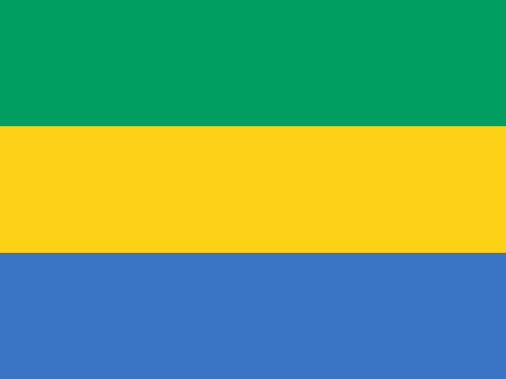
Gabon at a glance
- Capital
- Libreville
- Quiz continent
- Africa
- Languages in reference record
- French; other national languages among others catch
- Currency
- Central African CFA franc (XAF)
- Population
- 2,593,130 (2025, World Bank)
- Area
- 267,668 km²
- Coastal setting
- Not landlocked
- ISO codes
- GA / GAB
- Internet country suffix
- .ga
- Large river system
- Ogoouée
- Independence
- 17 August 1960
- Name of capital
- Libreville: Free City
- Highest archive value
- Mont Bengoué, 1,050 m
- Important raw material
- Manganese
- Mixed World Heritage
- Lopé-Okanda
Gabon Flag: Design, Meaning and History
Three equally wide horizontal stripes form the flag: green above, yellow in the middle, blue below. It contains no coat of arms and no star. For recognition, the order counts: The blue stripe is under the yellow. This distinguishes Gabon from many other states that combine green and yellow with red.
Green is assigned to forests and natural resources, yellow to the sun and the equator, blue to the sea. The flag was introduced in 1960 in connection with independence. Their concise design thus refers to three geographical bases, without focusing political history on a single heroic figure or military emblem.
Capital: Libreville
Libreville is located at the mouth of the Komo near the Atlantic Ocean. The capital is an administrative centre and one of the most important urban concentrations in the country. Their coastal position differs from the wide, much less populated hinterland. On a map it therefore appears on the edge of the territory, but in everyday economic life it forms an important center.
The French name means free city. The founding of 1849 is related to liberated enslaved people. This historical designation offers a concrete access to the Atlantic history and the French colonial period. It should not be read as a general description of freedom at that time, nor as a substitute for the difficult history of slavery and colonial rule.
Practise this capital →Gabon: Geography, History and Culture
The Ogooué drains a large part of Gabon to the Atlantic. Wet tropical forests characterise vast areas, while coastal lagoons, river valleys and savannah islands form additional habitats. The equator runs through the land. Seasonal rainfall differences are more important here than the idea of clear European summer and winter months. In the east and south there are also savannah spaces. It is precisely this juxtaposition of forest and open landscapes that makes Lopé-Okanda interesting and prevents the simplified idea of a completely closed forest cover everywhere.
French is an official language and various local languages are spoken. Focusing on a few larger cities does not mean that forest and river spaces are culturally empty. The World Heritage Entry Lopé-Okanda in particular makes it clear that human use and landscape history have belonged together for a very long time.
Petroleum, manganese and timber industry are important components of the economic structure in the factbook archive stand of 2025. Their importance explains traffic axes and economic interdependencies, but says little about individual living conditions. The protection of large forest areas stands alongside these usage interests. Gabon’s UNESCO sites provide concrete examples of this instead of describing the entire forest as untouched wilderness.
Lopé-Okanda
The Lopé-Okanda ecosystem and relic cultural landscape are inscribed as a mixed World Heritage site. Natural values and traces of human history are explicitly considered together there.
Ivindo
The Ivindo National Park became a UNESCO World Heritage Site in 2021. It complements the view of Gabon with another important forest and river area.
Equation Country
Gabon is on both sides of the equator. The middle yellow flag strip thus has a particularly clear geographical reference.
Explore neighbouring and related places
 Cameroon
 Republic of the Congo
 Equatorial Guinea
What did you discover?
Sources and image credits
This English article draws on the institutional sources listed below. Figures and memberships retain their stated reference dates.
Source record: 2 November 2026. A translation does not change the reference date of a figure or membership list.
- github.com/factbook/factbook.json/blob/144d6977b2b01ac1cbd220de754c0a005616760b/africa/gb.json
- data.worldbank.org/indicator/SP.POP.TOTL
- whc.unesco.org/en/statesparties/ga
- github.com/mledoze/countries