Argentina Flag, Capital and Country Facts
Argentina stretches from the subtropical northeast to the significantly cooler southern landscapes of Patagonia. The Andes form the western framework, the Atlantic Ocean borders the land to the east. Buenos Aires and the fertile Pampas are just one part of this great state, which includes equally dry highlands, glaciers and rainforest areas.
Test your knowledge →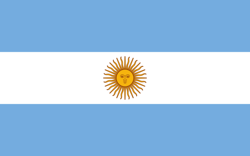
Argentina at a glance
- Capital
- Buenos Aires
- Quiz continent
- South America
- Languages in reference record
- Spanish; regional and indigenous languages including Guaraní, Quechua and Mapudungun
- Currency
- Argentine Peso (ARS)
- Population
- 45,851,378 (2025, World Bank)
- Area
- 2,780,400 km²
- Coastal setting
- Not landlocked
- ISO codes
- AR / ARG
- Internet country suffix
- .ar
- Highest mountain
- Aconcagua, 6,962 m
- Large landscape
- Pampas
- Southern Region
- Patagonia
- May Revolution
- 25 May 1810
- Declaration of Independence
- 9 July 1816
- Waterfall area
- Iguazú, Misiones province
Argentina Flag: Design, Meaning and History
The flag shows three horizontal stripes of equal width: light blue, white and again light blue. In the white middle strip stands a golden yellow sun with face and rays. This sun motif is the most important detail if you want to distinguish Argentina from a simple blue-white-blue stripe flag.
The so-called Maisonne refers to the May Revolution of 1810. It connects the state sign with the emergence of the independence movement, which preceded the formal independence of 1816. The colors are often associated with the sky and landscape; historically, the sun is the clearer concrete clue.
Capital: Buenos Aires
Buenos Aires is located on the Río de la Plata, whose wide estuary opens the access to the Atlantic Ocean. The city developed as a port and political center. Its name is usually rendered with “good skies” or “good winds” and comes from the older name of the port.
The autonomous capital can be distinguished from the surrounding province of Buenos Aires. This administrative separation is easily overlooked on cards because both bear the same name. The position of the port city explains at the same time its connection to trade and immigration and the difference to the regional centers further inland.
Practise this capital →Argentina: Geography, History and Culture
To the west, the Andes rise to Aconcagua, the highest mountain in South America. To the east of this are the Pampas, whose wide plains are important for agriculture and livestock farming. Patagonia forms a different landscape area in the south with dry plateaus and wetter mountain zones on the Andean edge.
The northeast belongs to the subtropical forest zone. There, the Iguazú National Park protects a large waterfall system on the border with Brazil. The Argentinian and Brazilian parks form neighbouring protected areas; the landscape is therefore a good example of ecosystems not ending at state borders.
Spanish characterizes the nationwide understanding, while indigenous languages and the history of immigration form further cultural layers. There are great spatial differences between the densely populated greater Buenos Aires area and the sparsely populated southern landscapes. Climate, distance and relief help to better understand this distribution.
Iguazú at the border
The UNESCO National Park is located in Misiones in the extreme northeast. Not only the waterfalls, but also the subtropical forest are part of the protective idea; on the Brazilian side, the area continues in the Iguaçu National Park.
A continental record
According to the Factbook archive, the Aconcagua reaches 6,962 meters. Its altitude makes it clear that Argentina has a very high alpine landscape in addition to plains and coasts, although many well-known pictures of the country come from the pampa.
Patagonian opposites
Patagonia is not a uniform ice landscape. Dry highlands in the east face glaciers and mountain landscapes in the west. The Andes influence the distribution of precipitation and help to explain this strong change within the same Greater Region.
Explore neighbouring and related places
 Bolivia
 Brazil
 Chile
 Paraguay
 Uruguay
Cities and regions in this country
 Buenos Aires
What did you discover?
Sources and image credits
This English article draws on the institutional sources listed below. Figures and memberships retain their stated reference dates.
Source record: 2 November 2026. A translation does not change the reference date of a figure or membership list.
- github.com/factbook/factbook.json/blob/144d6977b2b01ac1cbd220de754c0a005616760b/south-america/ar.json
- data.worldbank.org/indicator/SP.POP.TOTL
- whc.unesco.org/en/list/303/
- github.com/mledoze/countries