Chile Flag, Capital and Country Facts
Chile runs as a narrow state between the Pacific and the Andes over many latitudes. In the north lies the Atacama, in the center the densely populated area around Santiago, in the south follow lakes, fjords and islands. The country also includes Rapa Nui in the Pacific. Its geography is therefore at the same time continental, mountainous and spread far over the ocean.
Test your knowledge →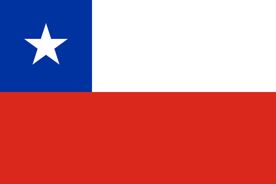
Chile at a glance
- Capital
- Santiago
- Quiz continent
- South America
- Languages in reference record
- Spanish; among others Mapudungun, Aymara and Rapanui
- Currency
- Chilean peso (CLP)
- Population
- 19,859,921 (2025, World Bank)
- Area
- 756,102 km²
- Coastal setting
- Not landlocked
- ISO codes
- CL / CHL
- Internet country suffix
- .cl
- Highest volcano
- Ojos del Salado, 6,893 m in the Factbook Archive
- Desert
- Atacama
- Parliament seat
- Valparaíso’
- Island in the Pacific
- Rapa Nui
- National holiday
- 18 September
- Shared sea
- Lake Carrera with Argentina
Chile Flag: Design, Meaning and History
The flag consists of a white upper stripe and a red lower stripe. In the upper left corner is a blue square with a white five-pointed star. The blue field is only as high as the white stripe. So unlike the flag of Texas, it does not take the entire height.
The single star has earned the flag the designation “La Estrella Solitaria”. The pattern dates back to the period of independence and has been used since 1817. Common interpretations connect white with the Andes, blue with the sky and red with the struggle for independence. For safe allocation, however, the position of the square and the individual star are particularly helpful.
Capital: Santiago
Santiago de Chile is located in the central part of the country in a basin on the western edge of the Andes. The Mapocho River crosses the city. Santiago combines important political and economic functions, but is not a seaport: access to the coast is via other cities and traffic axes.
An important addition to the capital question is Valparaíso: this is where the National Congress meets. The assignment of Santiago as the capital remains correct, although a central state institution sits in another city. At the same time, Valparaíso is a port city rich in tradition, which brings together political tasks and the historical significance of maritime trade in another place.
Practise this capital →Chile: Geography, History and Culture
Chile’s strong north-south expansion creates very different climates. The dry Atacama faces the rainy landscapes in the south. Between the coastal mountains and the Andes lies the central longitudinal valley with many settlements and agricultural land. This structure explains why a narrow state by no means has the same landscapes or conditions of use everywhere.
The Andes form a defining border with Argentina and reach great heights. The Ojos del Salado lies on this border and is given in the factbook archive with 6,893 meters. Chile is part of the Pacific ring of fire; earthquakes and volcanism are therefore essential natural conditions. The history of the country is also a history of dealing with these dangers.
Rapa Nui, also known as Easter Island, is located far west of the South American mainland and culturally belongs to Polynesia. The National Park with the monumental moai is on the UNESCO World Heritage List. This affiliation shows that the political map of Chile extends beyond the narrow continental strip. Indigenous languages and communities in the north, south and on Rapa Nui each have their own historical developments.
Rapa Nui
The National Park protects significant evidence of Rapanui culture. The well-known stone figures belong to a larger context of ceremonial platforms, settlement remains and landscape.
Desert next to high mountains
The Atacama reaches as far as the Andes. Extreme drought and high altitudes are geographically close together.
Two Political Places
Santiago is the capital, Valparaíso the seat of the Congress. Political geography cannot therefore be reduced to a single point.
Explore neighbouring and related places
 Argentina
 Bolivia
 Peru
What did you discover?
Sources and image credits
This English article draws on the institutional sources listed below. Figures and memberships retain their stated reference dates.
Source record: 2 November 2026. A translation does not change the reference date of a figure or membership list.
- github.com/factbook/factbook.json/blob/144d6977b2b01ac1cbd220de754c0a005616760b/south-america/ci.json
- data.worldbank.org/indicator/SP.POP.TOTL
- whc.unesco.org/en/list/715
- chile.gob.cl/chile/sistema-politico
- github.com/mledoze/countries