Buenos Aires: City Flag, History and Identity
Buenos Aires is the capital of Argentina and an autonomous city on the Río de la Plata. Its name must not be confused with the province of the same name, whose capital is La Plata. The white city flag shows a historical eagle coat of arms and thus tells a different symbolic story than today's city coat of arms with pigeons and ships.
Test your knowledge →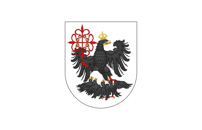
Buenos Aires at a glance
- Name
- Buenos Aires
- Country
- Argentina
- Profile type
- City
- Waters
- River de la Plata and Riachuelo
- Autonomy enshrined in national law
- 1994
- Own city constitution
- Since 1996
- Decentralised units
- 15 Comunas
- Named neighbourhoods
- 48 barrios
- Historical political place
- Plaza de Mayo
- Provincial capital of the neighbouring area of the same name
- La Plata’
- Flag adoption
- 1995; historical motif of 1580
The Flag of Buenos Aires
On a white background stands in the middle a black crowned eagle with a red cross. Beneath the large bird, four smaller eagles can be seen. The historical motif comes from the coat of arms adopted by Juan de Garay in 1580. The flag was established in 1995 as an official city banner, centuries after the creation of its motif.
The four small eagles are connected in the state symbol declaration with four planned city foundations. This historical imagery should not be read as a representation of today's urban districts. Equally important: The current city coat of arms shows a pigeon and two ships. Anyone who only knows this other coat of arms could mistake the eagle flag for a foreign city.
Buenos Aires: Location and Territorial Role
The Ciudad Autónoma de Buenos Aires has its own local institutions. The national constitutional reform of 1994 enshrined its autonomy; since 1996, the city has its own constitution. It is part of the federal division of Argentina, but not part of the province of Buenos Aires. The national seat of government and the municipal government are also different levels.
The city area is divided into 15 communes and comprises 48 barrios. These two divisions do not denote the same thing: barrios are designated neighborhoods, while communes serve the decentralized political and administrative organization. In order to understand the large conurbation, it is also important that the coherent development extends beyond the boundaries of the autonomous city.
Landscape, History and Culture
The Río de la Plata and the Riachuelo characterize the water sides of the city. The Riachuelo forms an essential part of its southern border and flows into the Río de la Plata. Especially La Boca is connected to this river area. The coastal and port location is therefore just as much a part of the cityscape as wide avenues and squares.
The Plaza de Mayo is a central place of political history. Its name is reminiscent of the revolution of May 1810. Around the square are the Cabildo, the cathedral and the Casa Rosada. The spatial proximity of these buildings makes visible how religious, colonial and national institutions overlap at the historical center.
The cultural landscape ranges from the Teatro Colón to smaller stages on Avenida Corrientes. San Telmo, La Boca and Puerto Madero show very different urban environments. Historic cafes, bookstores and tango are also part of the cultural profile. This diversity explains why Buenos Aires cannot be described solely through its capital function or a single landmark.
Plaza de Mayo
The oldest plaza in the city was the scene of many political events. The Casa Rosada and the Cabildo stand for different phases of state history. A view over the square therefore connects buildings and public gathering culture: not only the facades, but also the use of the space are part of the historical understanding.
San Telmo
San Telmo is one of the older neighborhoods of Buenos Aires. Paving streets, historic houses, antique offers and the Plaza Dorrego determine its well-known perception. The district complements the representative capital axis with smaller street spaces. It shows how strongly the identity of the entire city emerges from different neighborhoods.
Riachuelo and La Boca
Riachuelo is home to places closely linked to port work and the history of La Boca. The river also marks a transition between administrative areas. Its importance is therefore twofold: it is part of the lived urban landscape and a geographical reference point for the demarcation of the autonomous city from the province.
Explore this country and nearby profiles
 Argentina
What did you discover?
Take this flag into the quiz
Sources and image credits
This English article draws on the institutional sources listed below. Figures and memberships retain their stated reference dates.
Source record: 2 November 2026. A translation does not change the reference date of a figure or membership list.
- buenosaires.gob.ar/gcaba_historico/justicia/elecciones-2025-en-la-ciudad/organizacion-politico-territorial
- buenosaires.gob.ar/gcaba_historico/laciudad/barrios
- argentina.gob.ar/caba/simbolos
- buenosaires.gob.ar/gcaba_historico/plaza-de-mayo
- cancilleria.gob.ar/es/iniciativas/paba/buenos-aires
- buenosaires.gob.ar/areas/med_ambiente/riachuelo/
- argentina.gob.ar/buenosaires
- turismo.buenosaires.gob.ar/es/atractivo/san-telmo
- commons.wikimedia.org/wiki/File:Bandera_de_la_Ciudad_de_Buenos_Aires.svg