Washington, D.C.: City Flag, History and Identity
Washington, D.C. is a specially planned capital on the Potomac and Anacostia. Government seats, wide sight axes and the National Mall shape their familiar image. At the same time, the District of Columbia is an inhabited urban space with its own history. Its simple white-red flag is therefore associated with both the capital and local identity.
Test your knowledge →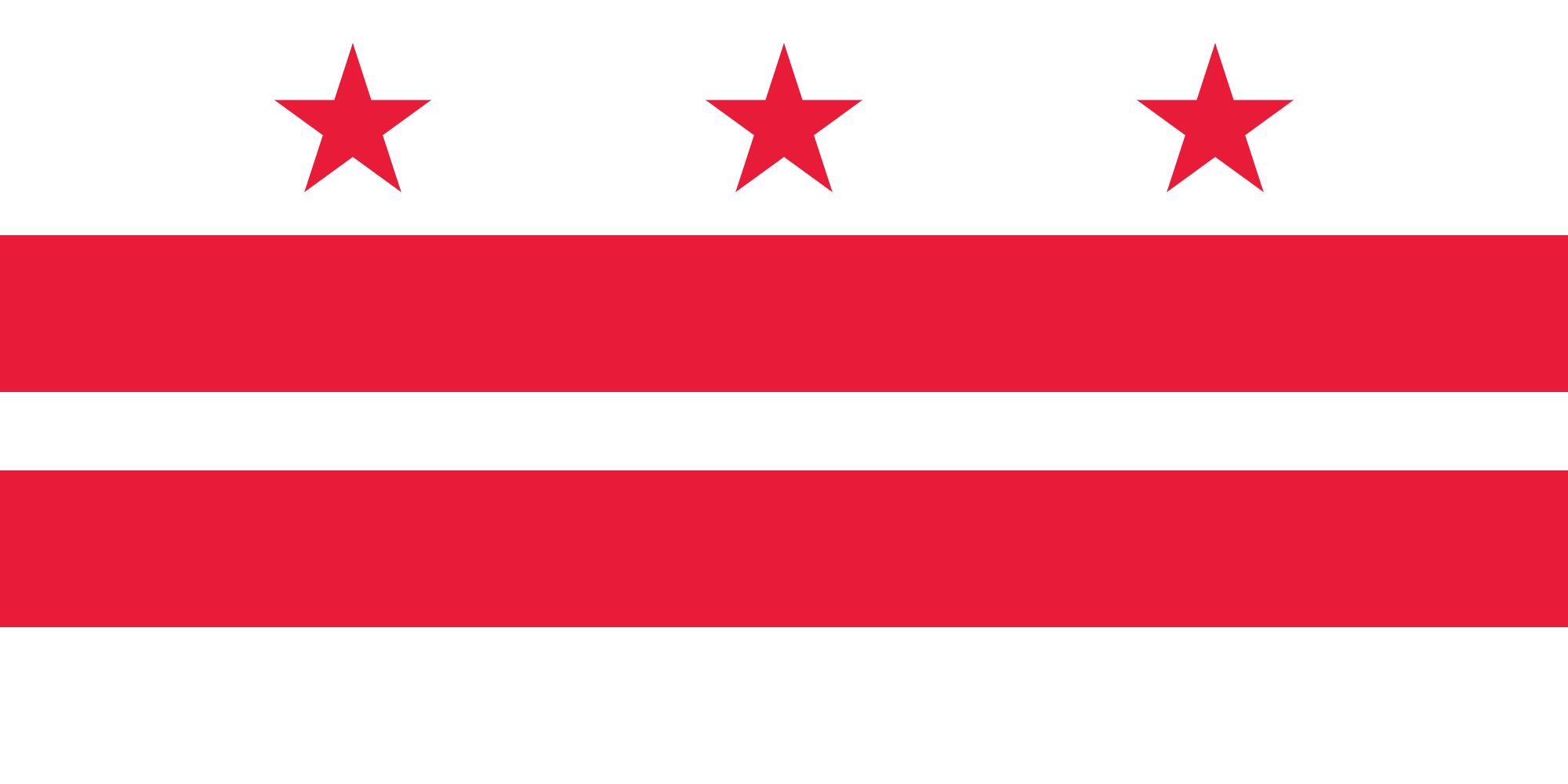
Washington, D.C. at a glance
- Name
- Washington, D.C.
- Country
- United States
- Profile type
- City
- Rivers
- Potomac and Anacostia
- Legal basis of the location decision
- Residence Act of 1790
- Planners of the early city floor plan
- Pierre L’Enfant
- Return of the Virginia Share
- 1846
- Formative later city plan
- The McMillan Plan of 1902
- Location of Capitol
- Capitol Hill
- Museum Institution at the Mall
- Smithsonian Institution
- Flag designers
- Charles A. R. Dunn, selected in 1938
The Flag of Washington, D.C.
Three red five-pointed stars stand in a row over two horizontal red bars on a white background. A white distance remains between the beams. The flag shows neither a seal nor an eagle. Their small number of clearly defined shapes makes them easily recognizable even without writing or complicated coat of arms elements.
The design of Charles A. R. Dunn was selected on October 15, 1938. Stars and beams come from the family coat of arms of George Washington. The District Council expressly points out that further interpretations of these figures do not replace the actual origin. The flag is therefore not a simplified image of the national Star Banner flag.
Washington, D.C.: Location and Territorial Role
The District of Columbia is the federal district of the United States and does not belong to any state. It lies where the Anacostia flows into the Potomac. Today’s Washington can be distinguished from the state of Washington on the Pacific coast. Both names are reminiscent of the same historical person, but denote completely different spaces.
The capital was established under the Residence Act of 1790. Pierre L’Enfant designed a road network linking a rectangular grid to diagonal avenues. Important public buildings and squares should be connected in this way. The large lines of the center therefore follow a conscious political and urban planning idea, not only older road courses.
Landscape, History and Culture
Potomac and Anacostia were crucial for the choice of location. The original district included areas on both sides of the Potomac that Maryland and Virginia had ceded. The share on Virginia's side was returned in 1846. The current borders can therefore not simply be equated with the original draft of the Federal District.
The planning history includes more than the first city plan. The McMillan Plan of 1902 especially influenced the open green spaces of the National Mall and the representative center. Such interventions show that Washington’s monumental appearance has evolved over a long period of time. The Washington Monument was not created in a single continuous construction process, but with a longer interruption.
On the National Mall are several museums of the Smithsonian Institution. They complement the political capital with large collections and public education offers. Washington can therefore be read at the same time as a place of government and a museum city. The museum landscape is an institutional structure with locations inside and outside the mall, not a single connected museum building.
National Mall
The National Mall is a large public space that connects museums, monuments and political memory. Its present form is based on several planning layers. Anyone who understands it as a mere free space between sights overlooks the fact that paths, eye relationships and open spaces are also part of the historical capital design.
Capitol Hill and Pennsylvania Avenue
L’Enfant placed the Capitol on an elevated location, today’s Capitol Hill. Pennsylvania Avenue was to connect it with the Presidential House. This connection shows how political institutions were spatially related in the city plan. Roads served here not only the traffic, but also the public legibility of the new capital.
Smithsonian museums
The Smithsonian Institution operates several homes along the National Mall as well as other facilities in the area. Their collections offer different approaches to history, science and culture. This is important for a city comparison: Washington’s cultural significance is based not only on state ceremonies, but also on permanently accessible places of knowledge.
Explore this country and nearby profiles
 United States
 New York City
 Chicago
 Los Angeles
 San Francisco
 California
 New York
What did you discover?
Take this flag into the quiz
Sources and image credits
This English article draws on the institutional sources listed below. Figures and memberships retain their stated reference dates.
Source record: 2 November 2026. A translation does not change the reference date of a figure or membership list.
- ncpc.gov/about/history/
- senate.gov/about/historic-buildings-spaces/meeting-places/washington-dc.htm
- dccouncil.gov/dc-flags-flown-wilson-building-now-available-purchase/
- si.edu/visit/museums
- commons.wikimedia.org/wiki/File%3AFlag_of_Washington%2C_D.C.svg