New York City: City Flag, History and Identity
New York City is a city of five boroughs on the North American Atlantic coast in the northeast. Its blue-white-orange flag leads to Dutch beginnings, while bridges, parks and waterways explain the later big city. If you only look at Manhattan’s high-rise buildings, you overlook the spatial diversity of this city in the US state of the same name.
Test your knowledge →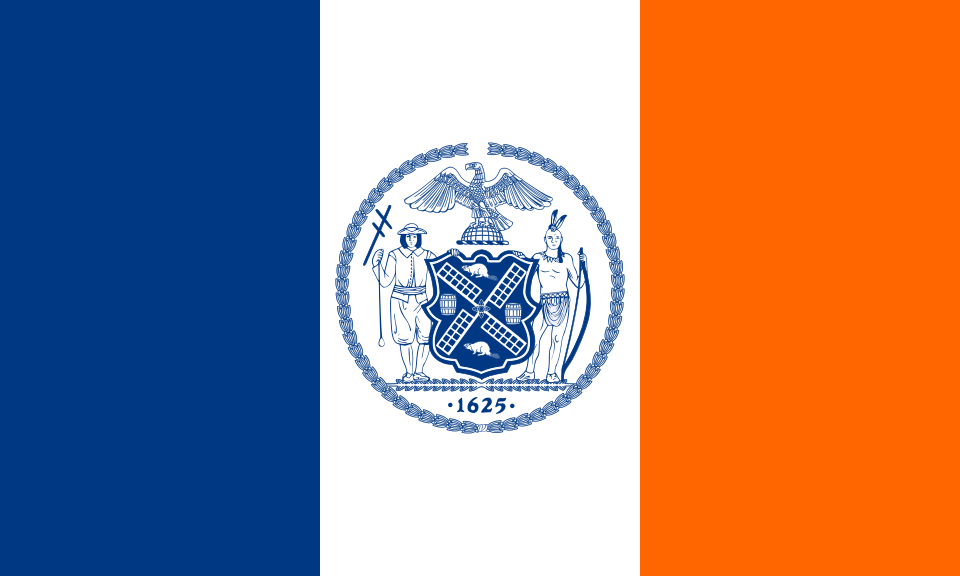
New York City at a glance
- Name
- New York City
- Country
- United States
- Profile type
- City
- Breakdown
- Five boroughs
- Boroughs
- Manhattan, Brooklyn, Queens, The Bronx, Staten Island
- Brooklyn County
- Kings County
- Staten Islands County
- Richmond County
- Merger
- 1898
- Bridge opening
- Brooklyn Bridge: May 24, 1883
- Crossed waterway
- East River
- Parking design
- Frederick Law Olmsted and Calvert Vaux
The Flag of New York City
The figure shows three vertical, equally wide paths: blue on the mast, white in the middle and orange on the outside. In the white field, the city seal is in blue. The order should be read from the mast; a mere enumeration of colors does not yet fully explain this flag.
The municipal regulation explicitly refers to the Dutch flag of 1625 for the colors. The seal connects, among other things, windmill blades with trade signs. This gives a local historical reference. The five additional stars of the mayor's flag are missing here; shown is the ordinary city flag with the seal.
New York City: Location and Territorial Role
New York City is located in the state of New York and is administratively divided into Manhattan, Brooklyn, Queens, The Bronx and Staten Island. These five names refer to boroughs. They must not be equated with five independent cities or with the entire state. The municipal urban area is the reference value of this page.
The boroughs correspond to five counties at the same time: Manhattan belongs to New York County, Brooklyn to Kings County, Queens to Queens County, The Bronx to Bronx County and Staten Island to Richmond County. The different names are especially helpful for historical documents. Town division and county designation form two distinct systems of order of the same space.
Landscape, History and Culture
The water situation is more than a backdrop for photographs. Between Manhattan and Brooklyn lies the East River, crossed by the Brooklyn Bridge. For a long time, ferries were crucial for connecting both shores. The bridge therefore makes visible how a growing city extended its transport relations permanently over the water.
The present-day Five Borough City was created by the merger of 1898. However, the city’s history dates back far before that. Brooklyn, in particular, had an independent urban development before the unification. Anyone who reads old cards with today's borough names should always consider this change in administrative boundaries and political belonging.
Public open spaces are just as much a part of the image of the metropolis as dense buildings. Central Park was created in the 19th century for the rapidly growing city. Its design combined recreation with a deliberately designed landscape experience. The seemingly natural in the middle of Manhattan is thus also an important example of urban planning.
Brooklyn Bridge
The Brooklyn Bridge opened on May 24, 1883. It connects Lower Manhattan with Brooklyn Heights and is easily recognizable by its stone arches. Its public walkway allows a special view of the river area. The bridge can be understood at the same time as a building and as a connection between two city stories.
Central Park
Frederick Law Olmsted and Calvert Vaux developed the design for Central Park. Meadows, water surfaces and paths should create a counter space to the compacted roads. The park is therefore not a randomly left plot. Its history shows the importance of accessible landscape in an expanding commercial city.
Seneca Village
Before the construction of Central Park, part of the site was home to Seneca Village, a predominantly African-American community with numerous landowners. The park required the displacement of the people living there. This prehistory adds a social perspective to the well-known landscape: The public recreational space was created on previously inhabited and used land.
Explore this country and nearby profiles
 United States
 Chicago
 Washington, D.C.
 Los Angeles
 San Francisco
 California
 New York
What did you discover?
Take this flag into the quiz
Sources and image credits
This English article draws on the institutional sources listed below. Figures and memberships retain their stated reference dates.
Source record: 2 November 2026. A translation does not change the reference date of a figure or membership list.
- nyc.gov/site/dcas/about/green-book-city-seal-and-flag.page
- portal.311.nyc.gov/article/
- nyc.gov/html/dot/html/infrastructure/brooklyn-bridge.shtml
- centralparknyc.org/park-history
- archaeology.cityofnewyork.us/collection/nyc-timeline/consolidation-of-the-five-borough-city
- commons.wikimedia.org/wiki/File:Flag_of_New_York_City.svg