Rostock: City Flag, History and Identity
Rostock is a city between Hanseatic old town, university and everyday maritime life. Its location on the Warnow connects the historic center with the Baltic Sea near Warnemünde. Brick gates, churches and university buildings tell of trade and education, while the different districts make it clear that Rostock has grown far beyond its old fortifications.
Test your knowledge →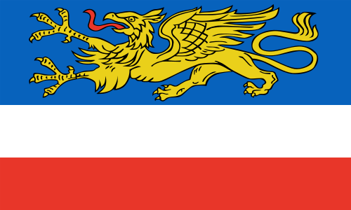
Rostock at a glance
- Name
- Rostock
- Country
- Germany
- Profile type
- City
- Urban river
- Warnow
- Coastal district
- Warning
- Foundation of the University
- 1419
- University opening
- 12 November 1419 in the Marienkirche
- Founding initiative
- City Council of Rostock
- Central city gate
- Kröpelin Gate
- Suburban codes
- KTV for Kröpeliner-Tor-Vorstadt
- Old Town Road
- Kröpeliner Straße
The Flag of Rostock
The flag shown has a blue field at the top with a golden griffin. This is followed by a white and a red track. The mythical animal is the most striking feature: it connects an eagle-like forebody with a lion-like forebody and lets the flag distinguish from simple blue-white-red stripe flags even without writing.
The white trajectory corresponds to silver in the heraldic language. When recognizing, you should pay attention to both the gripper and the color areas, because neither of the two features alone describes the whole flag. A supposedly natural meaning of all colors, such as a clear assignment to the sea or beach, is not claimed here.
Rostock: Location and Territorial Role
Rostock is located in the federal state of Mecklenburg-Western Pomerania on the Warnow. The river creates the spatial connection between the city centre and the coastal district of Warnemünde. Anyone who visits only the seaside resort therefore sees an important, but not the only part of the city: The older urban center is further inland on the same water body.
The Kröpeliner Straße and the Kröpeliner Tor give the centre a clearly recognizable direction. In front of the gate begins the Kröpeliner-Tor-Vorstadt, often called KTV. Already this name preserves the memory of the former city border. Today, historical landmarks are combined with a coherent urban everyday life outside the medieval walls.
Landscape, History and Culture
Brick is an essential material of the Rostock cityscape. At the Kröpeliner Tor it becomes apparent that a city fortification not only served military purposes, but also marked the border between the city and the surrounding countryside. The gate is therefore a good starting point for correlating roads, neighborhoods and former city entrances.
The university was opened in 1419. Its founding was largely due to the city council, which wanted to attract trained executives for the Hanseatic area. The opening ceremony took place on 12 November in the Marienkirche. In this way, Rostock shows particularly clearly how closely medieval trade, urban self-organization and academic education could be linked.
The university is not only a historical backdrop. It also explains why Rostock is understood as an educational and scientific location alongside the port and coast. The view of university buildings complements the perception of the Hanseatic city: international connections were not created here exclusively by ships and goods, but also by students, teachers and the exchange of knowledge.
Kröpelin Gate
The brick building is a concise landmark on the edge of the old city centre. Its effect is particularly evident from the connection with the Kröpeliner Straße and the adjoining suburb. Thus, a single tower becomes an indication of Rostock’s historical growth and the location of its former fortified borders.
University and Marienkirche
The Marienkirche was the site of the ceremonial university opening in 1419. The founding process can be traced unusually precisely on the basis of the university chronicle: Pope, bishop, landlords and city participated in different ways. Precisely this distribution of responsibilities shows that a university at that time was not a purely academic project, but also urban politics.
Kröpeliner-Tor-Vorstadt
The KTV is located immediately in front of the eponymous gate. Its name helps to understand the transition from the fortified city to later extensions. Together with the university location and the Warnow, this district offers an access to Rostock that goes beyond the usual idea of a city focused exclusively on the beach and port.
Explore this country and nearby profiles
 Germany
 Munich
 Cologne
 Frankfurt am Main
 Stuttgart
 Düsseldorf
 Dresden
What did you discover?
Take this flag into the quiz
Sources and image credits
This English article draws on the institutional sources listed below. Figures and memberships retain their stated reference dates.
Source record: 2 November 2026. A translation does not change the reference date of a figure or membership list.
- rathaus.rostock.de/de/bildung_wissenschaft/249303
- uni-rostock.de/universitaet/uni-gestern-und-heute/geschichte/chronik/epochen/1418-1563/
- rostock.de/poi/kroepeliner-tor
- rostock.de/poi/kroepeliner-tor-vorstadt
- rostock.de/poi/audio-warnemuende-06-alter-strom
- commons.wikimedia.org/wiki/File%3AFlagge_der_Hansestadt_Rostock.svg