Nuremberg: City Flag, History and Identity
Nuremberg is located on the Pegnitz and belongs to Mittelfranken. The red-and-white city flag stands for a former imperial city whose history combines trade, art and technical innovations. Above the old town lies the Kaiserburg. Between the river, churches and city walls, a spatial structure is recognizable that emerged well before industrial growth.
Test your knowledge →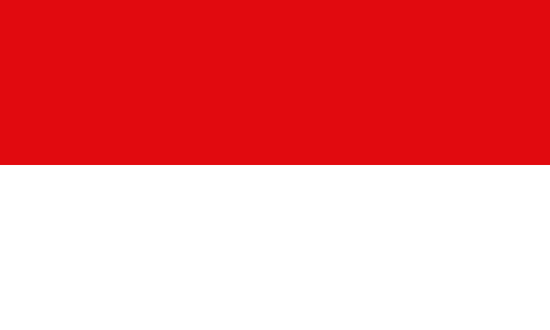
Nuremberg at a glance
- Name
- Nuremberg
- Country
- Germany
- Profile type
- City
- River
- Pegnitz
- Government district
- Medium francs
- First document in writing
- 16 July 1050, Sigena Certificate
- Golden bull
- 1356
- Custody of the Reichskleinodien
- 1424–1796
- Artists
- Albrecht Dürer
- Railway link
- Nuremberg–Fürth, 1835
- Old town churches
- St Sebald and St Lorenz
- Burgberg
- Sandsteinberg of the Kaiserburg
The Flag of Nuremberg
The simple city flag shown here consists of two horizontal tracks: red above and white below. A heraldic shield is missing in this variant. The House of Bavarian History mentions red and white for Nuremberg and also points to an oblique division. This page explicitly describes the horizontal version used in the image.
Nuremberg also has a large and a small city coat of arms. The big one shows a golden eagle with king's head on blue. In the small stand half a black eagle on gold and red-silver oblique stripes. These coats of arms explain a part of the heraldic tradition, but are not additional pictorial components of the simple flag shown here.
Nuremberg: Location and Territorial Role
The city is located in the Bavarian administrative district of Mittelfranken. The Pegnitz runs through the old town, while the imperial castle forms the northern high point. These two orientation elements help to understand the historical center: the city grew below the Burgberg and on both sides of the river. Today’s communal space extends far beyond this older core.
The city birthday is July 16, 1050. On that day, in Norenberc, the release of the serfs Sigena was notarized. The document is the first written proof of the place name, not the proof of a planned city foundation on this very day. It is precisely this distinction that makes the famous historical starting point understandable.
Landscape, History and Culture
North and south of the Pegnitz, different parts of the medieval city developed. The churches of St. Sebald and St. Lorenz give them names to this day. A largely preserved city wall holds the historic center. The connection between the river, churches and fortifications explains the cityscape more accurately than the mere enumeration of individual famous buildings.
The Golden Bull of 1356 designated Nuremberg as the site of the first Reichstag of a newly elected German king. From 1424 to 1796, the Reichskleinodien were also kept in the city. These tasks gave the Reichsstadt a special political role. They existed alongside trade and crafts, which supported their economic development.
In the late 15th and early 16th centuries, Albrecht Dürer, Veit Stoß and other important artists worked in Nuremberg. Science and humanism were also represented. The urban history emphasizes the interplay between economic prosperity and cultural production. Commercial contacts and craftsmanship formed an important background to this extraordinary urban flowering phase.
Kaiserburg
The Kaiserburg stands on the Sandsteinberg above the old town. Its location makes the historical connection between the dominion and the settlement immediately recognizable. The castle is therefore more than a viewpoint. It explains why the name Norenberc could refer to a rocky mountain and how the terrain influenced the development of the city.
The railway to Fürth
The Nuremberg-Fürth connection was opened in 1835 with the Adler locomotive. It is considered the first railway line in Germany with regular steam-powered passenger transport. The step stands for the industrial Nuremberg of the 19th century. In addition to the older history of long-distance trade and art, a new phase of technical infrastructure, production and urban growth has been added.
St Sebald and St Lorenz
The two large old town churches can be considered as a spatial pair. St. Sebald belongs to the northern side, St. Lorenz to the southern side of the Pegnitz. Their names help with orientation and are reminiscent of the development of different parts of the settlement. The medieval city was thus already before later expansions a structure of several centers, which connected bridges and common fortifications.
Explore this country and nearby profiles
 Germany
 Munich
 Cologne
 Frankfurt am Main
 Stuttgart
 Düsseldorf
 Dresden
What did you discover?
Take this flag into the quiz
Sources and image credits
This English article draws on the institutional sources listed below. Figures and memberships retain their stated reference dates.
Source record: 2 November 2026. A translation does not change the reference date of a figure or membership list.
- hdbg.eu/gemeinden/index.php/detail
- nuernberg.de/internet/stadtarchiv/stadtgeschichte.html
- nuernberg.de/internet/stadtarchiv/stadtgeschichte_daten.html
- tourismus.nuernberg.de/fileadmin/dokumente/presse/Allgemeine_Pressetexte/2024/Gr%C3%BCndung_der_Stadt.pdf
- hdbg.eu/gemeinden/index.php/detail
- nuernberg.de/imperia/md/stadtportal/dokumente/nh98_burg.pdf