Hanover: City Flag, History and Identity
Hanover is the state capital of Lower Saxony and is located on a leash. Its history combines medieval trade, princely residence and parliamentary present. Herrenhausen and the Leineschloss tell about it in different ways. On the red-white city flag stands the local coat of arms, whose wall, lion and green three-leaf form their own heraldic combination.
Test your knowledge →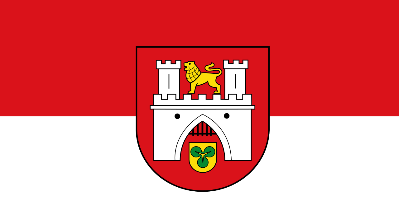
Hanover at a glance
- Name
- Hanover
- Country
- Germany
- Profile type
- City
- Urban river
- Leashes
- Confirmation of city rights
- 1241
- City of residence since
- 1636
- Personal Union with Great Britain
- 1714–1837
- State Parliament
- Lower Saxony Landtag in Leineschloss
- Municipal takeover of the Georgengarten
- 1921
- Historical Alley
- Mansion Alley
- Heraldic detail
- Green three-leaf in the small sign of the gate area
The Flag of Hanover
The flag shown here combines the city colors red and white with the coat of arms of Hanover. In the coat of arms appear a bright wall with two towers, a golden lion and a small golden shield with green three-leaf in the gate area. These details help with the assignment, because red and white are used by many cities.
The municipal statute representation refers to the green sign as clover leaf. However, an urban explanation at the New Town Hall suggests that its historical botanical interpretation is controversial. Therefore, a concrete symbol of happiness cannot be assumed as a secure origin. The city flag stands for Hanover as a municipality, while Lower Saxony has another national flag.
Hanover: Location and Territorial Role
Hanover is located in Lower Saxony and is the seat of the state parliament. The Leineschloss connects the state capital function with the local river location. The city of Hanover and the region of Hanover are different levels of administration. This is about the city and its flag; information on the larger region area would have a different spatial reference.
The early settlement core lay at a transition over the leash. Later, Hanover developed into a residence city; 1636 is an important date for this. New courtly buildings and gardens extended the older trading town. Today’s urban space therefore contains various historical focal points, instead of being arranged exclusively around a single medieval center.
Landscape, History and Culture
The leash and its lowering belong to the geographical basis of Hanover. On the river are important political and historical places, while other districts developed beyond the older center. The New Town Hall was built on the southern edge of the city centre on damp terrain. Even its elaborate foundation shows that representative architecture had to deal with concrete landscape conditions.
From 1714 to 1837, Hanover and Great Britain were connected by personal union. This meant a common ruler, not the merger of both territories into a commune or a country. This connection explains many international references of residence history. It belongs to a different political epoch than Hanover’s current role within the Federal Republic of Germany.
The Georgengarten complements the princely garden world of Herrenhausen with a landscape with extensive paths and tree groups. The city took it over in 1921. After damage and changes in use in the war, extensive work was necessary to restore it as a public park. Its history shows that even seemingly self-evidently grown green spaces are being changed politically and creatively.
Line lock
The castle is today connected with the Lower Saxony Landtag. Its history dates back to the residence of the Calenberg dukes, but has been altered by remodeling, destruction and new use. The location directly on a leash makes the connection between historical dominion, modern democracy and the geographical origin of the city particularly clear.
New Town Hall
The monumental New Town Hall is designed as a municipal representation building. Dome, side wings and rich building decoration distinguish it from the simpler picture of a purely administrative building. On the facade meet coats of arms and historical representations. Thus, the urban self-description becomes part of the architecture, while the construction at the same time shapes the silhouette on the inner city edge.
Georgengarten and Herrenhäuser Allee
The Herrenhäuser Allee runs through the Georgengarten and connects paths, rows of trees and historical garden rooms. Their trees were renewed after serious damage in the twentieth century. The complex is therefore not only a picture of the residence period, but also an example of the long-term care and restoration of public urban landscapes.
Explore this country and nearby profiles
 Germany
 Munich
 Cologne
 Frankfurt am Main
 Stuttgart
 Düsseldorf
 Dresden
What did you discover?
Take this flag into the quiz
Sources and image credits
This English article draws on the institutional sources listed below. Figures and memberships retain their stated reference dates.
Source record: 2 November 2026. A translation does not change the reference date of a figure or membership list.
- e-government.hannover-stadt.de/lhhSIMwebdd.nsf/3FC53A5C2F355225C125790C002D8F7D/%24FILE/1958-2011_Anlage4.pdf
- hannover.de/Kultur-Freizeit/Geschichte-Geschichten/Geschichte-der-Stadt-Hannover/Hannovers-Geschichte-in-Zahlen
- landtag-niedersachsen.de/leineschloss/
- herrenhaeuser-gaerten.hannover.de/Herrenhausen-erleben/Georgengarten-Welfengarten/Geschichte-des-Georgengartens
- hannover.de/Kultur-Freizeit/Geschichte-Geschichten/Echt-hann%C3%B6versch/Das-Neue-Rathaus-im-Detail/Rundgang-um-und-in-das-Neue-Rathaus/Das-Rathaus-von-Au%C3%9Fen-Nord
- commons.wikimedia.org/wiki/File%3AFlagge_Hannover.svg