Hamburg: City-State Flag, History and Identity
Hamburg is a city and a federal state at the same time. The white castle on red ground therefore denotes both the city and the state of Hamburg. The location on the lower Elbe connects inland and maritime transport. Memories, offices, port areas and the landscape on the Elbhang tell different chapters of a city whose development is closely linked to trade.
Test your knowledge →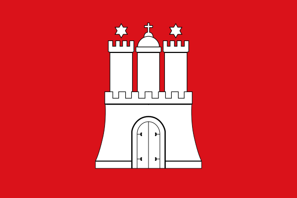
Hamburg at a glance
- Name
- Hamburg
- Country
- Germany
- Profile type
- City
- Additional role
- City and federal state
- River
- Elbe
- Landscape
- North German lowlands
- Administrative structure
- Seven districts
- Neighbourhood
- Schleswig-Holstein and Niedersachsen
- Historical storage quarters
- Storage city
- Office district of commerce
- Kontorhausviertel’
- Significant office building
- Chile house
- Viewpoint on the Geesthang
- Altona balcony
The Flag of Hamburg
The selected flag shows on red cloth a white castle with three towers. The middle tower carries a cross; above the side towers stand stars. The closed gate and the clear red-white combination belong to the familiar picture. An additional large coat of arms with shield holders is not available in this variant.
It is the Hamburgisches Landesflagge, whose current form was first established in 1834 by a Senate decision. It must be distinguished from the special state flag of the Senate and other Hamburg emblems. The castle shape goes back to urban seals. The joint role as a city and state sign follows from Hamburg’s position as a city-state.
Hamburg: Location and Territorial Role
The Free and Hanseatic City of Hamburg is located in the northern German lowlands at the lower reaches of the Elbe, well before its mouth into the North Sea. A seaport therefore does not have to be located directly on an open sea coast. The Elbe provides the connection between the city and the shipping routes via the North Sea.
The state of Hamburg is divided into seven districts: Hamburg-Mitte, Altona, Eimsbüttel, Hamburg-Nord, Wandsbek, Bergedorf and Harburg. The city borders Schleswig-Holstein and Lower Saxony. The larger metropolitan area extends beyond that. Their area must not be equated with the city-state, even if Hamburg forms its economic and spatial center.
Landscape, History and Culture
The Elbe landscape shows strong contrasts. On the northern shore are the Geesthang, parks and viewpoints; opposite port facilities characterize the silhouette. This combination of elevation differences, water and industrial use distinguishes Hamburg from a uniformly flat urban landscape. Public paths connect historical places along the river with landscape spaces and younger urban development areas.
The Speicherstadt was created as a warehouse quarter oriented towards international trade in goods. Its brick buildings, waterways and bridges form a coherent functional space. The Kontorhausviertel complements this picture with the office world of commerce. Both quarters make it clear that a port city is not only made up of quays: storage, administration and commercial organization also shape its architecture.
The landscape axis Elbe today connects very different public places. Old Elbtunnel, Fish Market and Övelgönner Museumshafen tell the story of the city from different angles. Parks on the Geesthang complement the harbour scenery with open spaces. These connections make the river bank a place where everyday life, recreation and economic history become immediately visible next to each other.
Storage city
The historic Speicherstadt shows the technical and spatial organization of the warehouse. Brick facades are not only a decorative cityscape, but also belong to an earlier logistics system. Together with the Kontorhausviertel and the Chilehaus, it forms the UNESCO World Heritage site in Hamburg, parts of which illustrate different tasks of the commercial city.
Kontorhausviertel’
In the Kontorhaus district, office buildings were concentrated for the business of international trade. The Chilehaus is a particularly striking example, but the connection with other buildings is crucial. From water to office work, a short spatial but important intellectual path leads through the economic history of Hamburg.
Altona balcony
On the Geesthang in Altona a wide view opens over the Elbe and the harbour facilities. The viewpoint makes the height difference between shore and slope experienceable. It is also part of a series of parks and paths that open up the river as a coherent landscape space within the city.
Explore this country and nearby profiles
 Germany
 Munich
 Cologne
 Frankfurt am Main
 Stuttgart
 Düsseldorf
 Dresden
What did you discover?
Take this flag into the quiz
Sources and image credits
This English article draws on the institutional sources listed below. Figures and memberships retain their stated reference dates.
Source record: 2 November 2026. A translation does not change the reference date of a figure or membership list.
- hamburg.de/politik-und-verwaltung/behoerden/senatskanzlei/hamburg-logo-239048
- marketing.hamburg.de/de/hamburg-medien-service/ueber-hamburg
- hamburg.de/politik-und-verwaltung/behoerden/behoerde-fuer-kultur-und-medien/themen/unesco-welterbe/welterbe-erklaert-flaeche-105908
- hamburg.de/politik-und-verwaltung/behoerden/bukea/themen/hamburgs-gruen/gruenes-netz/elbe-280146
- commons.wikimedia.org/wiki/File:Flag_of_Hamburg.svg