Bremen: City Flag, History and Identity
Bremen is located on the Weser river and combines a long history of trade with a political status that is particularly in need of explanation. The city of Bremen and the state of Freie Hansestadt Bremen are not congruent: Bremerhaven also belongs to the federal state. The red-white bacon flag is explained together here, while the two cities remain clearly distinguished as independent places.
Test your knowledge →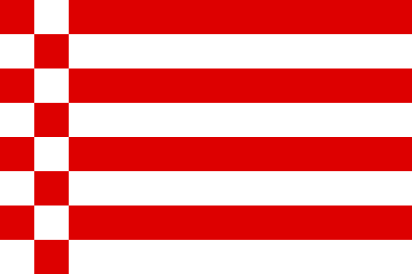
Bremen at a glance
- Name
- Bremen
- Country
- Germany
- Profile type
- City
- River
- Weser
- First documentary mention
- 782
- Cities of the state
- Bremen and Bremerhaven
- Country between urban areas
- Lower Saxony
- Acquisition for the port square Bremerhaven
- 1827
- Education of today's federal state
- 1947
- Roland statue
- 1404
- World Heritage City Hall and Roland
- Since 2004
The Flag of Bremen
The bacon flag shown consists of alternating red and white horizontal stripes. On the mast stand two rows of red and white rectangles offset against each other. In the selected simple form, no heraldic shield is placed. Together, stripes and diced borders produce a pattern that is distinctly different from simple red-white two-color flags.
The common name bacon flag alludes to the red-white effect of the pattern. Bremen also knows variants with state coats of arms. Anyone who sees such a picture should therefore not equate it with this unarmed form. The flag stands in the common historical connection between city and country, without making Bremerhaven geographically a district of Bremen.
Bremen: Location and Territorial Role
The city of Bremen is located in the northwest of Germany on the Weser. It is one of the two municipalities of the state of Freie Hansestadt Bremen. The other is Bremerhaven at the Weser estuary to the North Sea. Between the urban areas lies Lower Saxony territory; the federal state thus does not form a single contiguous metropolitan area.
This particular structure explains the designation two-city state. Bremen and Bremerhaven belong to a federal state, but each have its own municipal level. Information on the entire country area or the country population would therefore not be pure city values for Bremen. This page focuses on the city of Bremen, supplemented by the necessary explanation of the country.
Landscape, History and Culture
The Weser is Bremen’s most important geographical connection to the sea. As economic growth and the evacuation of the river confronted each other, a harbour place further seawards was needed. A contract with the Kingdom of Hanover made it possible to acquire land for Bremerhaven in 1827. The history of both cities is thus directly related to silting and river landscape.
Bremen is first documented in 782 and developed into a bishop and archbishop's seat. Later, trade strengthened its urban autonomy. The marketplace with Town Hall and Roland shows this bourgeois tradition particularly clearly. Sacred and commercial history therefore both belong to the origin of the city; no single institution alone explains them.
The present state was formed in 1947 from Bremen and Bremerhaven. The historical independence of Bremen, however, goes back much further. For the present, the connection of both cities is a special feature in German federalism. For the history of the city, its different origins remain important: the older Bremen inland and the younger Bremerhaven by the sea.
City Hall at the Market Square
The Old Town Hall was built in the early fifteenth century as a Gothic building. His later transformation into forms of the Weser Renaissance shaped the representative facade. UNESCO recognises the Town Hall and Roland together as evidence of urban autonomy. The town hall is therefore both an architectural monument and an expression of historical political demands.
Roland
The Roland statue from 1404 stands on the market square and embodies urban rights and freedom. Their connection with the City Hall is essential: both have been a UNESCO World Heritage site since 2004. Instead of just looking at a single figure, an entire public space can be understood here as a representation of civic independence.
Weser and Two-City History
The spatial separation of Bremen and Bremerhaven seems unusual on a map at first. Its origin is understandable by the need for a suitable seaport. The Weser connects both places in economic history, while their separate urban areas remind that a common federal state does not necessarily consist of a single commune.
Explore this country and nearby profiles
 Germany
 Munich
 Cologne
 Frankfurt am Main
 Stuttgart
 Düsseldorf
 Dresden
What did you discover?
Take this flag into the quiz
Sources and image credits
This English article draws on the institutional sources listed below. Figures and memberships retain their stated reference dates.
Source record: 2 November 2026. A translation does not change the reference date of a figure or membership list.
- landesportal.bremen.de/zwei-staedte-staat
- landesportal.bremen.de/geschichte-bremens
- landesportal.bremen.de/bremer-landessymbole
- whc.unesco.org/en/list/1087
- commons.wikimedia.org/wiki/File:Flag_of_Bremen.svg