Berlin: City-State Flag, History and Identity
Berlin is simultaneously the German capital, city and federal state. The common side therefore deals with the bear flag in both local roles. Their habitat ranges from the dense city center on the Spree to parks, forests and older settlement cores. This diversity explains why Berlin is more than a single historical center or government district.
Test your knowledge →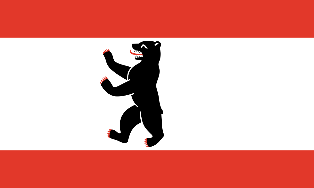
Berlin at a glance
- Name
- Berlin
- Country
- Germany
- Profile type
- City
- Additional role
- City and federal state
- Urban river
- Spree
- Administrative structure
- Twelve districts
- Medieval initial settlements
- Berlin and Cölln
- Historical independent centres
- Spandau and Köpenick
- Landscape framework
- Spreetal, Teltow and Barnim
- Origin of the Great Tiergarten
- Electoral hunting area
- World Heritage Museum Island
- Since 1999
- Parliamentary and Government Retreat
- 20 June 1991
The Flag of Berlin
The flag shows a black erect bear on a wide white middle strip. Above and below are narrower red stripes. The bear has red details on the tongue and claws. In the selected form, it stands on the cloth without a crowned heraldic shield; the country flag is therefore to be distinguished from the complete country coat of arms.
The bear has been part of Berlin’s heraldry for centuries. The official representation of the coat of arms also includes a silver shield and a golden crown; these elements are not transferred to the flag here. Because Berlin is a city-state, the flag denotes the same territorial body when it appears in connection with the city or the federal state.
Berlin: Location and Territorial Role
Berlin is located in a landscape characterized by the Spree in the east of Germany. The urban area is also the territory of the federal state of Berlin. An additional surrounding region with its own capital Berlin does not exist here. The city is divided into twelve districts, whose names and historical cores reflect different paths of urban development.
The medieval merchant settlements of Berlin and Cölln were located on both sides of the Spree in today's Mitte district. Later, the city grew together with previously independent places. Spandau and Köpenick first developed as their own settlement nuclei. The current city floor plan can therefore be understood better as a connection of several centers than as a mere enlargement of a single marketplace.
Landscape, History and Culture
The Spree Valley and the high altitudes of Teltow and Barnim form important natural foundations of the urban area. Settlements, fields, meadows and forests developed differently depending on the soil and location. The waterway was economically significant. To this day, river areas and larger green spaces help to spatially structure the extensive urban landscape.
The planning of public green spaces is part of Berlin’s city history. Previous castle gardens and the hunting grounds of the Great Tiergarten became important open spaces of the city center. Later planning sought connections between parks, gardens and landscape spaces on the edge. Berlin’s greenery is thus not only a remainder of undeveloped area, but also the result of conscious urban design.
The Museum Island shows Berlin as a place of collection and education. The ensemble of historical museum buildings was recognized as a UNESCO World Heritage site in 1999. Buildings and exhibited collections belong together here. The island makes visible how the idea of a public museum was implemented over a long period of time and complements the capital function with an independent cultural perspective.
Berlin and Cölln
The starting point of the medieval trading town was at the crossing over the Spree. The two settlements are a reminder that even the historical center was formed from several parts. Those who look at the watercourses and island areas can more easily understand the early situation than on the basis of today's administrative boundaries alone.
Large animal garden
The Great Tiergarten was originally an electoral hunting ground and today belongs to the essential green spaces in the dense city center. Its history explains how stately landscapes were able to transition into a public urban space. At the same time, the park creates a clear spatial opposite pole to built-up quarters in the center.
Museum Island
The Museum Island is an ensemble with various buildings and collections. Its World Heritage status pays tribute not only to individual exhibits, but also to the connection between museum architecture and public collection ideas. It can therefore be seen both as part of the river landscape in the center and as a testimony to European museum history.
Explore this country and nearby profiles
 Germany
 Munich
 Cologne
 Frankfurt am Main
 Stuttgart
 Düsseldorf
 Dresden
What did you discover?
Take this flag into the quiz
Sources and image credits
This English article draws on the institutional sources listed below. Figures and memberships retain their stated reference dates.
Source record: 2 November 2026. A translation does not change the reference date of a figure or membership list.
- berlin.de/sen/inneres/buerger-und-staat/verfassungs-und-verwaltungsrecht/hoheitszeichen/
- berlin.de/geschichte/
- berlin.de/sen/uvk/natur-und-gruen/landschaftsplanung/chronik-der-freiraumentwicklung/
- whc.unesco.org/en/list/896
- commons.wikimedia.org/wiki/File:Flag_of_Berlin.svg