Lower Austria: State Flag, Capital and Regional Profile
Lower Austria surrounds Vienna and connects Danube landscapes with the Waldviertel, the Weinviertel and alpine heights in the south. St. Pölten is the state capital of the multifaceted federal state. The blue-yellow flag with its golden eagle coat of arms points to a historical national identity, while the four traditional quarters still provide a particularly vivid geographical orientation.
Test your knowledge →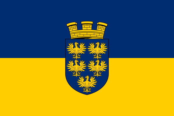
Lower Austria at a glance
- Name
- Lower Austria
- Country
- Austria
- Profile type
- Austrian federal state
- Administrative seat in source record
- St. Pölten
- Large river
- Danube
- Northern quarters
- Waldviertel and Weinviertel
- Southern quarters
- Mostviertel and Industrieviertel
- Highest mountain
- Schneeberg, 2,076 meters
- Significant Voralpenberg
- Ötscher, 1,893 meters
- World Heritage Sites
- Wachau
- Bordering Wachauorten
- Melk and Krems
- Border lake to Styria
- Erlaufsee
- Historical Quarter Map
- George Matthew Vischer, 1697
The Flag of Lower Austria
The flag shown is divided horizontally blue-yellow. In the center is a blue coat of arms with five golden eagles; above it stands a golden crown of the wall. The eagles are arranged and recognizable as a common group. This selection is thus the coat of arms form and not only the simple combination of the country colors.
For distinguishing from other blue-yellow flags, the five-eagle coat of arms is crucial. It is read as a historical landmark and not as a depiction of real animals in today's Lower Austria. The crown belongs to the present drawing variant. Statements about the flag should separate these actually visible details from subsequent color interpretations.
Lower Austria: Location and Territorial Role
Lower Austria borders the Czech Republic in the north and Slovakia in the east. Vienna forms its own federal state and is therefore not part of Lower Austria, although the two rooms are closely intertwined. St. Pölten fulfills the political capital function; other cities have their own historical and economic priorities.
The Danube flows through the country from west to east. To the north are Waldviertel and Weinviertel, to the south are Mostviertel and Industrieviertel. This traditional outline helps in understanding the landscape. However, the neighbourhoods are not four current political districts and their borders do not correspond exactly with modern administrative lines everywhere.
Landscape, History and Culture
The Waldviertel and the Weinviertel already refer with their names to different landscape traditions. South of the Danube, the spectrum ranges from fruit-growing landscapes to the pre-Alps and Alps. The Snow Mountain is the highest mountain in the country. This means that Lower Austria encompasses far more than the flat spaces around the federal capital.
The Wachau is a section of the Danube Valley between Melk and Krems. Viticulture, places, monasteries and castle ruins are in a close spatial connection there. UNESCO pays tribute to a developed cultural landscape whose present appearance preserves many historical layers of development. The river is both a connecting line and a basic scenic framework.
The historical quarter division is made traceable in official maps. One basis is the map of Georg Matthäus Vischers from 1697. For newer datasets, ambiguous assignments had to be partially adjusted at the municipal or district level. This shows how historical spatial conceptions and today’s geoinformation combine in a meaningful way without being identical.
Wachau
The cultural landscape of the Wachau connects vineyards with settlements and monumental buildings. Their value lies precisely in the interaction of these elements. A single monastery therefore explains the space just as little completely as a vineyard without the surrounding places, paths, slopes and the course of the Danube.
Schneeberg and Ötscher
The Schneeberg reaches 2,076 meters, the Ötscher reaches 1,893 meters. Both mountains illustrate the alpine part of Lower Austria. The Ötscher trenches complement the picture with cut valleys and show how much southern landscapes can differ from the northern hill country and from wider Danube areas.
Lakes in the Mostviertel
Lunzer See and Erlaufsee are among the largest natural lakes in Lower Austria. Through the Erlaufsee runs the border to Styria. This example in particular makes it clear that natural waters and political spaces are not always congruent and that a lake can belong to several regional contexts.
Explore this country and nearby profiles
 Austria
 Vienna
 Salzburg
 Graz
 Linz
 Innsbruck
 Burgenland
What did you discover?
Take this flag into the quiz
Sources and image credits
This English article draws on the institutional sources listed below. Figures and memberships retain their stated reference dates.
Source record: 2 November 2026. A translation does not change the reference date of a figure or membership list.
- noe.gv.at/noe/Persoenliche-Ausweise-Dokumente/Version_Druckvorlage_Juni_2021.pdf
- noel.gv.at/noe/Karten-Geoinformationen/NOE_Viertelsgrenzen_A3.pdf
- whc.unesco.org/en/list/970/
- noe.gv.at/noe/Geschichte-Landeskunde/Geschichte___Landeskunde.html