Burgenland: State Flag, Capital and Regional Profile
Burgenland forms Austria’s eastern transition to the Pannonian landscape. Around Lake Neusiedl, viticulture, reeds, villages and cross-border cultural history come together, while more closely divided hill landscapes follow further south. The red-and-yellow flag with the eagle coat of arms marks a federal state whose membership of Austria only took its present form in the early twentieth century.
Test your knowledge →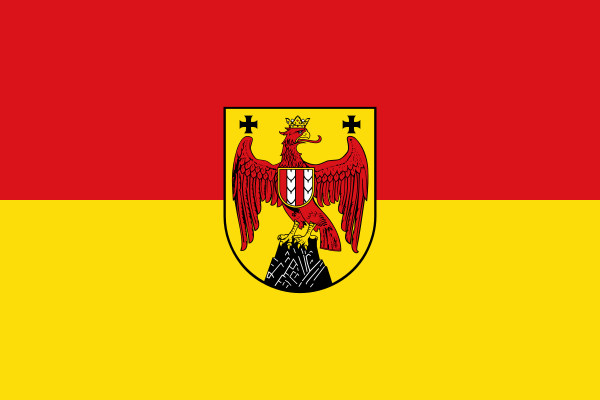
Burgenland at a glance
- Name
- Burgenland
- Country
- Austria
- Profile type
- Austrian federal state
- Administrative seat in source record
- Eisenstadt
- Great lake
- Neusied See
- Eastern Landscape
- Pannonian lowlands
- Sea sub-chamber
- Sea angle
- Northern high altitude
- Guidance mountain range
- River
- Wulka
- Previous affiliation
- Until 1918 Hungarian half of the Reich
- Transition to Austria
- 1921
- Border opening
- 1989
- Cross-border World Heritage
- Fertö/Neusiedler See
The Flag of Burgenland
The flag selected shows a red upper and a yellow lower stripe. In the center is a yellow sign with a red eagle. The animal and the additional heraldic details make this crest-bearing variant clearly distinguishable from a mere red-and-yellow two-color flag.
The eagle belongs to the coat of arms and should not be equated with the Austrian eagle. For the image determination, the yellow shield, the red animal and the two horizontal country colors are decisive. The flag does not describe a concrete castle or seascape, even if such motifs are associated with the country name.
Burgenland: Location and Territorial Role
Burgenland lies along the Austrian-Hungarian border. Eisenstadt is his state capital. The elongated form connects northern, middle and southern landscapes whose natural conditions differ significantly. Therefore, the well-known maritime space is only a part of the federal state and not a complete picture of its geographical diversity.
The geography of the country includes the foothills of the Central Alps, the edges of the Pannonian lowlands and the hill countries. Leithagbiirge, Parndorfer Platte, Seewinkel and Wulka plain are important names for orientation. Several rivers drain east to the Danube; among them are Leitha, Wulka, Pinka, Lafnitz and Raab.
Landscape, History and Culture
The Neusieddler See and the Seewinkel form an extraordinary natural area of Central Europe. Reeds, open water areas and the surrounding cultural landscape are closely related. The landscape can be viewed both ecologically and culturally: natural conditions influence agriculture and settlements, while centuries of use have helped shape today's appearance.
Until 1918, the present territory belonged to the Hungarian half of Austria-Hungary. The transition to Austria was politically contested after the First World War and completed in 1921. Ödenburg, today's sopron, remained with Hungary after a referendum. This explains why the emergence of the country and today’s borders are closely linked.
The history of Burgenland is also a history of linguistic and cultural diversity. German- and Croatian-speaking population groups were among the people whose everyday lives changed due to the new border. Connections to Lower Austria and Styria existed before. Political reorganization did not create a completely new landscape here without older relationships.
Cultural landscape on the lake
The UNESCO site Fertö/Neusiedl Lake is located on both sides of the Austrian-Hungarian border. It pays tribute to a long-term cooperation between people and the environment. Village architecture, agricultural use and stately buildings are therefore just as much a testament to the world heritage as the striking location on the lake.
Opening of the border
In 1989, Burgenland gained a special European significance due to the opening of the Hungarian border. The symbolic cutting through of the border fence at Klingenbach stands for this change. From a strongly dividing border, a space of more intensive encounters and joint projects developed again.
Common national park idea
Already in 1988, Austria and Hungary formulated the wish for a common national park in the maritime area. The project shows that water, bird life and other ecological relationships extend beyond state borders. The cross-border perspective therefore directly complements the historical and geographical view of Burgenland.
Explore this country and nearby profiles
 Austria
 Vienna
 Salzburg
 Graz
 Linz
 Innsbruck
 Carinthia
What did you discover?
Take this flag into the quiz
Sources and image credits
This English article draws on the institutional sources listed below. Figures and memberships retain their stated reference dates.
Source record: 2 November 2026. A translation does not change the reference date of a figure or membership list.
- burgenland.at/verwaltung/land-burgenland/geschichte/
- burgenland.at/verwaltung/land-burgenland/geographie-topographie/
- burgenland.at/verwaltung/land-burgenland/geschichte/1988-heute/
- whc.unesco.org/en/list/772/