Innsbruck: City Flag, History and Identity
Innsbruck is located on the Inn between the mountain trains of Tyrol. The name of the city preserves the memory of the river crossing that favored its development. The old town, Goldenes Dachl and Nordkette show how traffic conditions, Habsburg representation and alpine landscape are intertwined here. The city banner shown takes with its bridge coat of arms exactly this original spatial reference.
Test your knowledge →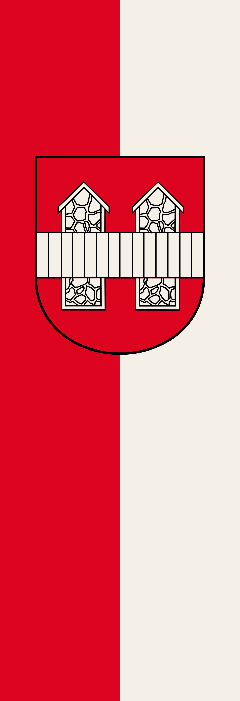
Innsbruck at a glance
- Name
- Innsbruck
- Country
- Austria
- Profile type
- City
- Urban river
- Inn
- valley space
- Inntal
- Northern Mountain Frame
- Northern chain
- Source of origin
- Exchange agreement with Wilten 1180
- Urban survey
- between 1187 and 1204
- Golden roof
- Built between 1497 and 1500
- Roof shingles
- 2,657 gold-plated copper shingles
- Contracting entities of the roof
- Emperor Maximilian I.
The Flag of Innsbruck
The file shows a vertical red-and-white banner with the city coat of arms placed on it. In the red sign is a white bridge. This motif is the most important reference to Innsbruck. The long hanging format is part of the concrete presentation; therefore, in the description it should not be tacitly shortened to a simple transverse flag without a coat of arms.
The bridge is a talking coat of arms motif, because it takes up the city name figuratively. At the same time, it refers to the internal transition that made the place economically important. The heraldic bridge is not simply a true-to-scale drawing of today's road bridge. A historical sign can preserve its reference, even if the actual building has been renewed several times.
Innsbruck: Location and Territorial Role
Innsbruck is the capital of Tyrol and is located in the Inn Valley. The northern chain forms a directly visible alpine framework north of the city. The connection between the valley space and the mountains is particularly close here: from central areas, the Nordkettebahnen lead via the Hungerburg in the direction of the Seegrube and Hafelekar, far above the dense buildings.
The old town was built in conjunction with a river crossing and traffic between north and south. An exchange agreement of 1180 between the Andechser and the Wilten Abbey is one of the important sources of their creation. The town was built between 1187 and 1204. The present state capital thus has a medieval core, whose location is understandable from ways and rights of rule.
Landscape, History and Culture
The Inn is not only the namesake, but also a landscaping and urban reference point. The historic bridge connected the old town with older settlement areas on the other side of the river. Repeated renewals show that such transitions were permanently needed, but their structural form depended on flooding, technology and the possibilities of the respective time.
The Golden Roof was built on behalf of Emperor Maximilian I between 1497 and 1500. It is a late Gothic showpiece with 2,657 gilded copper shingles. The combination of unusual roof surface and representative location later made it the most famous landmark of Innsbruck. Today, the associated museum conveys the time at the transition from the Middle Ages to modern times.
Innsbruck connects the historic center and high alpine surroundings in a modern city experience. The mountain railways not only provide a viewpoint, but also a change of landscape to the Karwendel. The view from the mountain back into the valley explains the limited valley location and makes it clear why roads, river and settlement areas are so closely connected.
Golden roof
The bay is more than a shiny roof. It belonged to the representation of princely power and only with the advent of tourism in the late 19th century became the well-known city landmark. The exact number of its gilded shingles helps to capture the craftsmanship behind the striking overall impression and view the building as a designed object.
Innbrücke and city name
The connection between bridge and city name makes Innsbruck a particularly memorable example of speaking heraldry. In the city coat of arms, a traffic building becomes the permanent sign of the commune. On site, it is therefore not only worth looking at the bridge itself, but also at the districts and paths that connect the river crossing.
Nordkette and Karwendel
The Nordkettebahnen connect the city centre through several sections with high-altitude stations. At the Hafelekar, the view of the Karwendel opens. This proximity of different altitudes is an essential feature of Innsbruck: The city can be understood as an administrative center in the valley and as a starting point in a significantly different mountain landscape.
Explore this country and nearby profiles
 Austria
 Vienna
 Salzburg
 Graz
 Linz
 Burgenland
 Carinthia
What did you discover?
Take this flag into the quiz
Sources and image credits
This English article draws on the institutional sources listed below. Figures and memberships retain their stated reference dates.
Source record: 2 November 2026. A translation does not change the reference date of a figure or membership list.
- innsbruck.gv.at/freizeit/kultur/museen-stadtarchiv/museum-goldenes-dachl
- presse.innsbruck.gv.at/news-stadtgeschichte-hautnah-erleben
- nordkette.com/
- nordkette.com/en/hafelekarbahn/karwendel-view/
- commons.wikimedia.org/wiki/File%3ABanner_Innsbruck.svg