Portugal Flag, Capital and Country Facts
Portugal is located in the west of the Iberian Peninsula on the Atlantic Ocean. The state also includes Madeira and the Azores, whose location extends the geographical view far beyond the mainland. The capital Lisbon is located at the mouth of the Tejo. Flag, ports and historical buildings tell of monarchy, republic, seafaring and the consequences of colonial expansion.
Test your knowledge →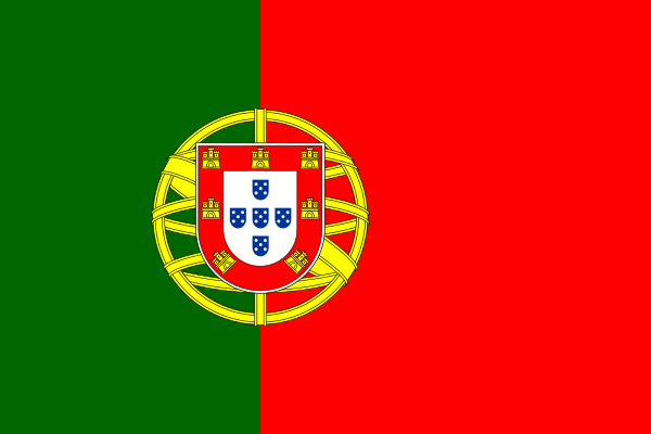
Portugal at a glance
- Capital
- Lisbon
- Quiz continent
- Europe
- Languages in reference record
- Portuguese; Mirandés regionally recognized
- Currency
- Euro (EUR)
- Population
- 10,804,871 (2025, World Bank)
- Area
- 92,090 km²
- Coastal setting
- Not landlocked
- ISO codes
- PT / PRT
- Internet country suffix
- .pt
- Highest mountain
- Ponta do Pico, 2,351 m
- Capital river
- Tejo
- Single neighbour
- Spain
- Republic since
- 1910
- National holiday
- 10 June
- Atlantic island groups
- Azores and Madeira
Portugal Flag: Design, Meaning and History
The flag has a green left field and a larger red right field. Green takes up two-fifths of the width, red three-fifths of the width. On the dividing line, the coat of arms stands in front of a golden armillary sphere. In the heraldic shield, smaller blue shields and golden castles can be seen. It is not an evenly divided two-color flag.
The green-red design was introduced after the proclamation of the Republic in 1910 and established in 1911. The coat of arms preserves older historical signs, while the armillary sphere reminds of the maritime tradition. Color explanations such as green for hope and red for sacrifice are common, but not every popular interpretation is a clear historical explanation of origin.
Capital: Lisbon
Lisbon is located on the wide estuary of the Tejo near the Atlantic Ocean. The capital is therefore closely linked to port traffic and historical sea routes. The Portuguese name Lisboa refers to the same city. Porto is another important center in the north, but is located on the Douro and is not the capital.
The Belém Tower and the Hieronymite Monastery have been on the UNESCO World Heritage List together since 1983. The buildings refer to the maritime and commercial history of the 16th century. This also includes the critical classification of colonial expansion and enslaved work: Maritime connections were not only voyages of discovery, but also power and violence relations.
Practise this capital →Portugal: Geography, History and Culture
The Tejo roughly separates the mountainous northern interior from southern areas more strongly characterized by plains and hill country. The Atlantic coast influences the climate, while stronger temperature contrasts occur inside. Portugal owns on land only Spain as neighbors. This location explains the strong importance of sea routes for connections outside the peninsula.
The highest mountain of the state is not on the European mainland, but on the Azores island of Pico. The volcano reaches 2,351 meters. Madeira and the Azores, like other North Atlantic archipelagos, belong to the Macaronesian region. Political affiliation, geographical island space and distance from the mainland are therefore three different aspects of the same state map.
The history of state independence dates back to the Middle Ages; independence was restored in 1640 after the personal union with Spain. The republic was not formed until 1910. Portuguese spread through colonial rule in several regions of the world and is today spoken in independent states. Linguistic connections such as to Brazil or Cape Verde are thus historical relationships and not today's state affiliation.
Belém on the Tejo
The tower and monastery have been a UNESCO World Heritage site since 1983. Its location combines architecture with the former access to Atlantic routes.
Highest summit on an island
Ponta do Pico is located in the Azores. The highest point in Portugal is thus far from the mainland mountains.
Continental and Atlantic archipelagos
Madeira and the Azores are part of the state. A map of Europe showing only the mainland therefore shows Portugal incompletely.
Explore neighbouring and related places
 Spain
Cities and regions in this country
 Lisbon
 Azores
 Madeira
What did you discover?
Sources and image credits
This English article draws on the institutional sources listed below. Figures and memberships retain their stated reference dates.
Source record: 2 November 2026. A translation does not change the reference date of a figure or membership list.
- github.com/factbook/factbook.json/blob/144d6977b2b01ac1cbd220de754c0a005616760b/europe/po.json
- data.worldbank.org/indicator/SP.POP.TOTL
- whc.unesco.org/en/list/263/
- github.com/mledoze/countries