Madeira: Regional Flag, Capital and Regional Profile
Madeira designates both an island and the autonomous Portuguese region, which includes other islands and archipelagos. Funchal is located on the south coast of the main island. The blue-yellow-blue flag bears the Cross of the Order of Christ. Laurel forest, water canals and Porto Santos long sandy beach show how different the landscapes can be within the same region.
Test your knowledge →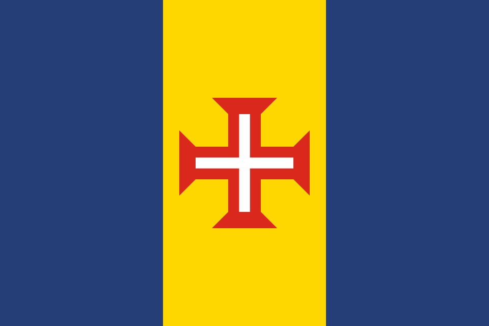
Madeira at a glance
- Name
- Madeira
- Country
- Portugal
- Profile type
- Autonomous region
- Administrative seat in source record
- Funchal
- Inhabited Islands
- Madeira and Porto Santo
- Other island groups
- Desertas and Selvagens
- Funchals City Law
- 21 August 1508
- Funchal's name reference
- Fennel
- Laurissilva World Heritage Site
- Since 1999
- Water infrastructure
- Levadas for water distribution
- Porto-Santo beach
- About nine kilometres long
- Desertas Islands
- Ilhéu Chão, Deserta Grande and Bugio
The Flag of Madeira
The flag is vertically divided into three equally wide fields: blue, yellow and blue. In the middle of the yellow field lies a red cross with widened ends and a white inner cross. It is the Cross of the Christ Order. Other crest figures or lettering are not present on the flag shown.
The official design rules list heraldic blue and gold as basic colors and set the central position of the Order Cross exactly. The shape is therefore not any red cross on a tricolor. His special drawing connects the regional flag with a Portuguese historical symbolic tradition, without it being possible to derive a modern religious affiliation of all inhabitants.
Madeira: Location and Territorial Role
The region includes Madeira and Porto Santo as inhabited islands, as well as the Desertas and Selvagens, which form important protected areas. The island and the region are therefore not congruent. Even a natural feature of the main island may not automatically apply to Porto Santo, which shows a different landscape character with its long bright sandy beach.
Funchal is located on a bay and extends amphitheater-like on a slope over the Atlantic Ocean. The place received 1508 city rights. Its name is derived from the fennel, which was abundant at the creation of the settlement. Sugar and wine later played an important role in its development as a trading centre.
Landscape, History and Culture
The Laurissilva is an evergreen forest type, of which a particularly important remnant has been preserved in Madeira. The forests cover steep valleys and have numerous species found only in Madeira or Macaronesia. Their value is therefore not only in old trees, but also in the interaction of plants, animals, climate and water balance.
Levadas are artificial water channels that run through the island along the terrain forms. They lead water, among other things, to settlements, irrigation areas and power generation plants. Accompanying paths make their lines visible in the terrain. The canals thus also explain economic use and the difficulties of distributing water in a steep island world.
Porto Santo is the smaller of the two inhabited islands. Its roughly nine kilometres long sandy beach shapes the image of the south coast. The contrast to Madeira’s humid, wooded mountains is particularly instructive: within an autonomous region, landscapes can differ significantly, although they are closely linked politically and historically.
Laurissilva as a World Heritage Site
Since 1999, Madeira’s Laurissilva has been a UNESCO World Heritage Site. The forest preserves a type of vegetation that used to be common in much larger parts of Europe. Among its characteristic birds is the Madeira pigeon. Its protection also helps the water balance, because vegetation and soil retain precipitation and moisture in the landscape.
Desertas and its marine environment
The Desertas are located southeast of the main island. The protected area includes Ilhéu Chão, Deserta Grande and Bugio as well as neighboring rock islands and marine areas. This spatial extent is important: island conservation does not automatically end at the shoreline, because land areas and surrounding waters together form habitats and ecological relationships.
Funchal in a regional context
Funchal’s location on the hillside makes sea and mountainous hinterland meet immediately. The capital is a commercial and cultural centre, but not a substitute for the entire island group. Those who locate Funchal, Laurissilva, Porto Santo and Desertas separately get a much more accurate picture of the region than a single general idea of a green holiday island.
Explore this country and nearby profiles
 Portugal
 Lisbon
 Azores
What did you discover?
Take this flag into the quiz
Sources and image credits
This English article draws on the institutional sources listed below. Figures and memberships retain their stated reference dates.
Source record: 2 November 2026. A translation does not change the reference date of a figure or membership list.
- idr.madeira.gov.pt/portal/ficheiros/Rumos/Guia_Normas_IP_Rumos.pdf
- visitmadeira.com/en/travel-info/about-us-and-where-we-are/
- visitmadeira.com/en/where-to-go/madeira/south-coast/funchal/
- visitmadeira.com/en/where-to-go/porto-santo/porto-santo/
- whc.unesco.org/en/list/934/
- ifcn.madeira.gov.pt/pt/areas-protegidas/laurissilva-da-madeira-patrimonio-mundial/laurissilva-da-madeira
- ifcn.madeira.gov.pt/pt/areas-protegidas/ilhas-desertas.html