Philippines Flag, Capital and Country Facts
The Philippines is a sprawling island nation between the South China Sea and the open Pacific Ocean. Thousands of islands belong to the large areas Luzon, Visayas and Mindanao. The flag picks up this three-star division. In addition, it carries a sun with eight rays, which has a different historical reference.
Test your knowledge →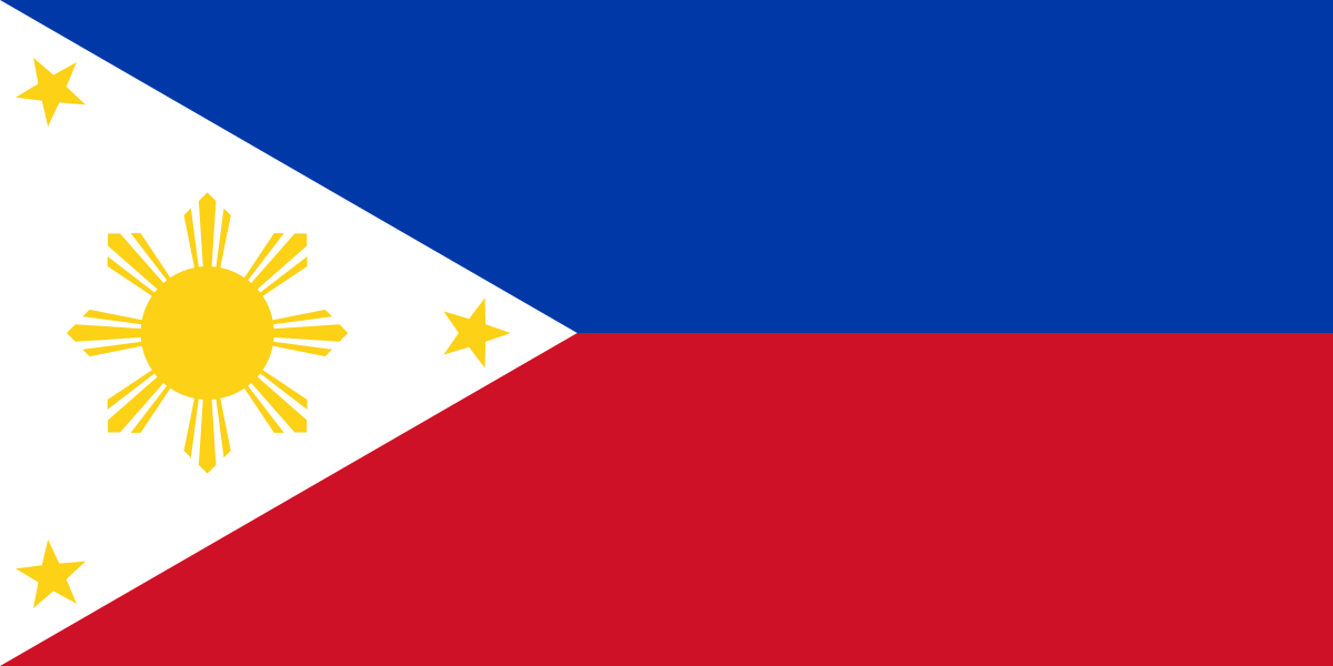
Philippines at a glance
- Capital
- Manila
- Quiz continent
- Asia
- Languages in reference record
- Filipino and English; numerous regional languages
- Currency
- Philippine peso (PHP)
- Population
- 116,786,962 (2025, World Bank)
- Area
- 342,353 km²
- Coastal setting
- Not landlocked
- ISO codes
- PH / PHL
- Internet country suffix
- .ph
- Largest northern island
- luzon
- Large southern island
- Mindanao
- Central archipelago
- Visayas
- Highest mountain
- Mount Apo, about 2,954 m
- River through Manila
- Pasig
- Flag Sun
- Eight main beams
Philippines Flag: Design, Meaning and History
Two equally high transverse stripes show blue at the top and red at the bottom. On the left is a white equilateral triangle. In it stand a yellow sun with eight main rays and three yellow five-pointed stars in the corners. The Sun is the most striking detail; it should not be confused with a single large star.
The three stars stand for Luzon, Visayas and Mindanao. The eight rays of the sun are reminiscent of the first eight provinces of the uprising against Spanish colonial rule. Blue is associated with peace and justice, red with courage. A special rule concerns the case of war: then the flag with the red stripe can be led upwards. In the quiz, the peace order appears.
Capital: Manila
Manila is located on Luzon on the Manila Bay near the mouth of Pasig. The capital is part of the larger Metro Manila conurbation. This includes several cities; therefore, Manila is not simply another name for the entire metropolitan space. The difference is important when comparing city size, administrative boundaries and national capital function.
The historical role of Manila is closely linked to port trade and the Spanish colonial period. The fortified urban area of Intramuros is one of the well-known historical reference points. At the same time, today’s metropolis is much larger than this old core. The capital and historical district therefore denote different spatial levels, even if they often coincide in the tourist picture.
Practise this capital →Philippines: Geography, History and Culture
The archipelago is located on the Pacific Ring of Fire. Volcanism, earthquakes and tropical hurricanes are among the natural hazards, but differ regionally. Mountains, narrow coastal plains, reefs and straits determine the traffic and settlement spaces. Island numbers also depend on the rules of collection and counting; a seemingly exact number explains the spatial diversity less well than the structure of the large island groups.
Filipino and English are official languages. Cebuano, Ilokano and numerous other languages show that the state is not monolingual. The Spanish and later American colonial periods left different traces. Historical churches and urban structures are therefore just as much a part of the country’s image as older agricultural cultural landscapes and local language traditions.
The rice terraces of the Philippine Cordillera and the historic city of Vigan are part of the UNESCO cultural heritage. Natural World Heritage sites such as Tubbataha and the underground river of Puerto Princesa show other habitats. Especially the comparison between terraced mountains and marine reef areas makes it clear how little a single landscape picture can represent the entire island state.
Three stars, eight rays
The stars stand for the large island spaces, the sun rays for historical provinces of the uprising. Both number symbols have different meanings.
Manila and Metro Manila
Manila is the capital city within a larger metropolitan area. The overall name includes several independent cities.
Reefs and rice terraces
Tubbataha and the Kordillera Terraces represent natural and cultural heritage respectively. The UNESCO profile makes the span of the landscapes visible.
Explore neighbouring and related places
 Afghanistan
 Armenia
 Azerbaijan
 Bahrain
 Bangladesh
 Bhutan
What did you discover?
Sources and image credits
This English article draws on the institutional sources listed below. Figures and memberships retain their stated reference dates.
Source record: 2 November 2026. A translation does not change the reference date of a figure or membership list.
- github.com/factbook/factbook.json/blob/144d6977b2b01ac1cbd220de754c0a005616760b/east-n-southeast-asia/rp.json
- data.worldbank.org/indicator/SP.POP.TOTL
- whc.unesco.org/en/statesparties/ph
- github.com/mledoze/countries