Peru Flag, Capital and Country Facts
Peru connects a dry Pacific coast with high Andes and the tropical forest areas of the Amazon basin. The capital Lima lies on the coast, while many well-known Inca sites are located in the mountains. The red-white-red flag shown here is the simple national flag without a coat of arms. This exact distinction prevents confusion with Peruvian official flag variants.
Test your knowledge →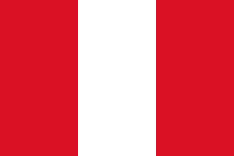
Peru at a glance
- Capital
- Lima
- Quiz continent
- South America
- Languages in reference record
- Spanish; Quechua, Aymara and other indigenous languages with regional official status
- Currency
- Peruvian sol (PEN)
- Population
- 34,576,665 (2025, World Bank)
- Area
- 1,285,216 km²
- Coastal setting
- Not landlocked
- ISO codes
- PE / PER
- Internet country suffix
- .pe
- Declaration of Independence
- 28 July 1821
- National holidays
- 28 and 29 July
- Capital river
- Rímac
- Port of Lima
- Callao
- Shared sea
- Lake Titicaca with Bolivia
- Historical Inca Center
- Cusco
Peru Flag: Design, Meaning and History
Three equally wide vertical stripes form the flag: red on both sides, white in the middle. The variant used in the quiz has expressly no coat of arms. Thus, it differs from Canada, for example, whose red side pattern contains a maple leaf, and from Austria's horizontal red-white-red streak sequence.
In addition to this simple flag, Peru also uses official variants with state coats of arms. In it appear, among others, Vikunja, Chinese bark tree and cornucopia. These motifs must not be transferred to the flag actually shown here. Red and white date back to the period of independence; common interpretations call the struggle for independence and peace, while historical narratives of origin are not all secured.
Capital: Lima
Lima is located near the Pacific Ocean on the River Rímac. The Spanish city foundation of 1535 developed into the political and economic center of the Vice Kingdom of Peru. The present capital is thus located in a different landscape zone than Cusco, the historical center of the Inca Empire in the Andean highlands.
The historic centre of Lima is a UNESCO World Heritage site. Its colonial urban complex, churches and public buildings document its role as an administrative and commercial centre. The neighboring port of Callao connects the greater area with the Pacific Ocean. The capital and the port form a tightly intertwined space, remaining geographically and administratively distinct places.
Practise this capital →Peru: Geography, History and Culture
The three commonly used large areas are called Costa, Sierra and Selva: coast, Andes and eastern woodland. They differ in altitude, climate and traffic conditions. The dry coast is dependent on rivers from the mountains. East of the watershed, on the other hand, rivers lead into the Amazon basin. The Andes thus separate and connect several very different habitats. The coastal rivers overcome great differences in altitude over a short distance.
Quechua and Aymara are important indigenous languages, but by no means the only ones. Other linguistic communities live in the Amazon region, among others. Inca history is a significant part of cultural heritage, but it does not include all older or present-day societies in Peru. Archaeological sites on the coast, in the highlands and in the woodlands expand the view beyond the most famous monuments.
Machu Picchu is located in an impressive mountain landscape and is also a UNESCO cultural and natural heritage. The plant cannot be understood separately from the site and its ecological conditions. Further southeast, Peru shares Lake Titicaca with Bolivia. Such cross-border and landscape connections are more helpful for the country profile than a mere list of sights.
Machu Picchu in the mountains
UNESCO protects the site and the natural environment together. The situation explains why architecture, slope shapes and water management are closely related here.
Coast and highland centres
Lima is located on the coast, Cusco in the mountains. The two cities thus stand for different political epochs and geographical spaces.
One flag, several variants
The civilian national flag remains without a coat of arms. Official coat of arms variants explain why reference works can show different Peruvian flag images.
Explore neighbouring and related places
 Bolivia
 Brazil
 Chile
 Colombia
 Ecuador
What did you discover?
Sources and image credits
This English article draws on the institutional sources listed below. Figures and memberships retain their stated reference dates.
Source record: 2 November 2026. A translation does not change the reference date of a figure or membership list.
- github.com/factbook/factbook.json/blob/144d6977b2b01ac1cbd220de754c0a005616760b/south-america/pe.json
- data.worldbank.org/indicator/SP.POP.TOTL
- whc.unesco.org/en/list/274
- app4.ign.gob.pe/capitulos/uno/estado.php
- github.com/mledoze/countries