Maldives Flag, Capital and Country Facts
The Maldives consists of small coral islands and atolls in the Indian Ocean southwest of India and Sri Lanka. Large sea areas separate the individual island groups. The capital Malé is densely built and clearly differs from the image of a remote holiday island. On the flag stand a green rectangle and a white crescent on a red background.
Test your knowledge →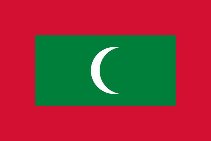
Maldives at a glance
- Capital
- Malé
- Quiz continent
- Asia
- Languages in reference record
- Dhivehi
- Currency
- Rufiyaa (MVR)
- Population
- 529,676 (2025, World Bank)
- Area
- 300 km²
- Coastal setting
- Not landlocked
- ISO codes
- MV / MDV
- Internet country suffix
- .mv
- Written text
- Thaana
- Writing direction
- From right to left
- Natural island groups
- 26 atolls according to the factbook archive 2025
- Independence
- 26 July 1965
- Historical buildings
- Coral stone mosques
- Characteristic occupation
- Fishing
Maldives Flag: Design, Meaning and History
A red border surrounds the large green rectangle of the flag. In its center is a white crescent moon whose opening points to the right. The motif contains neither stars nor a lettering. For recognition, the nested color fields are helpful: red forms the outer surface, green the central field and white the only pictorial symbol.
The crescent stands in Islamic symbolic tradition. Green is associated with peace and prosperity in the factbook archive of 2025, red with the people who defended the country. The meaning of the colors does not replace the exact description of their location. Just a mere enumeration of red, green and white would also fit in with completely different national flags.
Capital: Malé
Malé is located on a small island within the central archipelago. The capital is home to important state institutions and a significant part of urban activities. Their very dense construction makes the limited land area visible. The national space can therefore not only be understood in square kilometres of land: connections via the sea are a fundamental part of daily life.
The capital region also includes other islands and infrastructures in the area, but the name Malé remains the capital's name. This spatial context explains why aerial images can show several closely connected islands. A natural island, an administrative unit and a functional urban region are different terms that are particularly easily confused in an atoll state.
Practise this capital →Maldives: Geography, History and Culture
Atolls are annular or approximately annular reef structures with lagoons. The islands on top of it are low and consist of material that is closely linked to the reef ecosystem. This distinguishes the Maldives from high volcanic island states. Changes in coastline, corals and sea level therefore have a direct effect on settlements, freshwater resources and the usable land area.
Dhivehi is the national language and is written in the Thaana script. The scripture runs from right to left. Islamic traditions characterize historical mosques and other cultural testimonies. The UNESCO country profile mentions the coral stone mosques on the list of proposals. Their materials show particularly clearly how architecture can react to the possibilities of an island environment.
Fishing and tourism are among the most important economic activities. They are based on different uses of the same marine space: as habitat, transport route and landscape. A resort island cannot be equated with every inhabited island. There are considerable differences between the capital, local settlements and tourist-used islands, which easily obscures a general island paradise image.
Coral stone mosques
UNESCO lists historic coral stone mosques as a proposed World Heritage site. Proposal status does not yet mean registration on the World Heritage List.
Atoll and Island
An atoll is a larger reef structure with lagoon. A single island on it and the entire atoll are therefore not the same.
Dense capital
Malé forms a strong contrast to sparsely built islands. The scarce land area directly shapes settlement form and infrastructure.
Explore neighbouring and related places
 Afghanistan
 Armenia
 Azerbaijan
 Bahrain
 Bangladesh
 Bhutan
What did you discover?
Sources and image credits
This English article draws on the institutional sources listed below. Figures and memberships retain their stated reference dates.
Source record: 2 November 2026. A translation does not change the reference date of a figure or membership list.
- github.com/factbook/factbook.json/blob/144d6977b2b01ac1cbd220de754c0a005616760b/south-asia/mv.json
- data.worldbank.org/indicator/SP.POP.TOTL
- whc.unesco.org/en/statesparties/mv
- github.com/mledoze/countries