Laos Flag, Capital and Country Facts
Laos is located in the interior of Southeast Asia between China, Vietnam, Cambodia, Thailand and Myanmar. Mountains and the Mekong shape its geography. As the only landlocked country in the region, it has no sea coast. The flag shows a white disc in a broad blue stripe; below and above are narrower red ribbons.
Test your knowledge →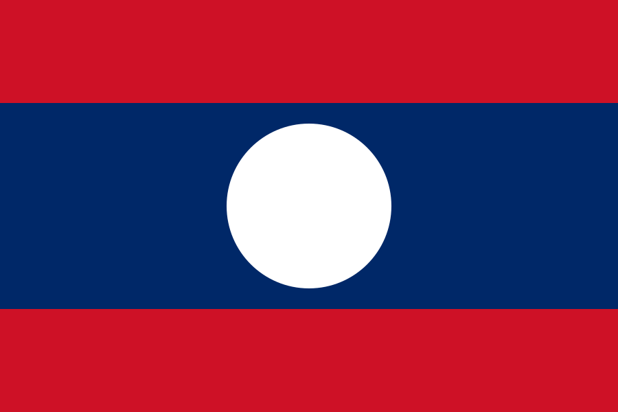
Laos at a glance
- Capital
- Vientiane
- Quiz continent
- Asia
- Languages in reference record
- Lao; numerous minority languages
- Currency
- Lao-Kip (LAK)
- Population
- 7,873,046 (2025, World Bank)
- Area
- 236,800 km²
- Coastal setting
- Landlocked
- ISO codes
- LA / LAO
- Internet country suffix
- .la
- Large river
- Mekong
- Historic Royal City
- Luang Prabang
- Archaeological landscape
- Plane of clay pitchers
- Highest mountain
- Phou Bia, about 2,817 m
- State since
- Democratic People's Republic since 1975
- Southern Cultural Site
- Vat Phou
Laos Flag: Design, Meaning and History
The three horizontal flag stripes are not the same width: the blue midfield is twice as wide as any red outer band. In its center is a large white disc. The ratio of stripes and the circular sign distinguish Laos from many other red-blue flags. Stars, coats of arms or lettering do not appear in the motif shown.
Red is associated with the liberation struggle, blue with the Mekong and prosperity. The white disc is interpreted, among other things, as a full moon over the Mekong and as a sign of national unity. Thus, the symbolism connects a concrete geographical reference with a political statement. Today’s motif belongs to the Democratic People’s Republic founded in 1975.
Capital: Vientiane
Vientiane is located on the Mekong, which also forms the border with Thailand. The capital is thus located on the western edge of the country and not in its geometric center. The river is at the same time a transport area, a source of water and an international border. These various functions explain why he is more than a mere map feature for understanding the capital.
The Sanctuary That Luang is an important reference point in Vientiane. UNESCO lists it on the proposal list, not as a registered World Heritage Site. Luang Prabang in the north, on the other hand, already has World Heritage status. The two cities are therefore easy to compare, but must not be confused geographically or in terms of their UNESCO status.
Practise this capital →Laos: Geography, History and Culture
Large parts of Laos are mountainous and wooded. Along the Mekong and its tributaries lie important settlement and agricultural areas. The river forms longer border sections, but does not run everywhere on the state border. A look at the entire river therefore helps more than the simplified idea that Mekong and the western border are identical over the whole route.
Lao is the official language; in addition, many other languages are spoken. Buddhist monasteries characterize many cities and villages, but the cultural landscape is regionally diverse. Luang Prabang combines religious facilities with a historical urban structure. In the south, Vat Phou and the surrounding cultural landscape represent a different historical epoch and other political connections.
The plain of clay pitchers in Xiengkhuang shows another archaeological side of the country. Its megalithic vessels have been a UNESCO World Heritage site since 2019. Since the extension of the Phong Nha-Ke Bang cross-border World Heritage Site to Hin Nam No, Laotian natural heritage has also been represented. The recognition combines the protection of contiguous landscapes across the border with Vietnam.
Wide blue midfield
The blue band occupies half of the flag height. It carries the white disc, which is often declared as a full moon over the Mekong.
Plane of clay pitchers
The archaeological sites in Xiengkhuang are world heritage sites. They show that in addition to monasteries and temples, Laos also has important prehistoric sites.
Cross-border karst
Hin Nam No is part of a joint natural heritage site with Vietnam. Natural connections extend here beyond the political border of the country.
Explore neighbouring and related places
 Myanmar (Burma)
 Cambodia
 China
 Thailand
 Vietnam
What did you discover?
Sources and image credits
This English article draws on the institutional sources listed below. Figures and memberships retain their stated reference dates.
Source record: 2 November 2026. A translation does not change the reference date of a figure or membership list.
- github.com/factbook/factbook.json/blob/144d6977b2b01ac1cbd220de754c0a005616760b/east-n-southeast-asia/la.json
- data.worldbank.org/indicator/SP.POP.TOTL
- whc.unesco.org/en/statesparties/la
- github.com/mledoze/countries