Thailand Flag, Capital and Country Facts
Thailand lies in the heart of the Southeast Asian mainland and extends far south with a long peninsula. Bangkok is located on Chao Phraya near the Gulf of Thailand. Mountainous north, central lowlands, Khorat plateau and southern coastal areas form different large landscapes whose history cannot be explained solely by the present capital.
Test your knowledge →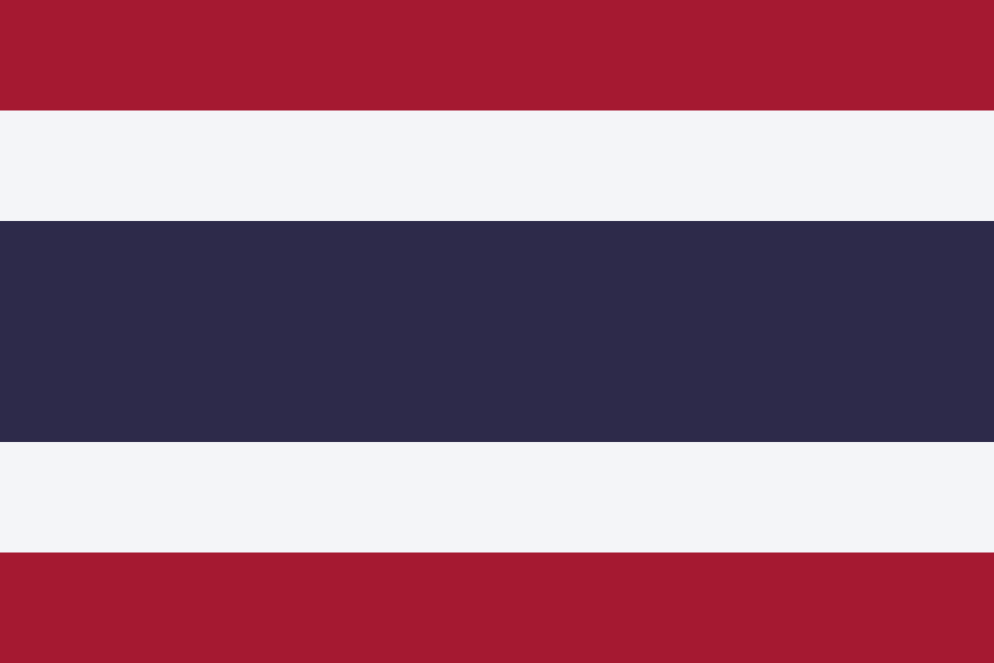
Thailand at a glance
- Capital
- Bangkok
- Quiz continent
- Asia
- Languages in reference record
- Thai; also including regional Tai languages, Malay and other minority languages
- Currency
- Thai Baht (THB)
- Population
- 71,619,863 (2025, World Bank)
- Area
- 513,120 km²
- Coastal setting
- Not landlocked
- ISO codes
- TH / THA
- Internet country suffix
- .th, .ไทย
- Highest mountain
- Doi Inthanon, 2,565 m
- Capital river
- Chao Phraya
- Northeastern landscape
- Khorat plateau
- Former capital
- Ayutthaya
- Historical centre
- Sukhot shark
- Western Southern Sea
- Andaman Sea
Thailand Flag: Design, Meaning and History
The flag consists of five horizontal stripes in red, white, blue, white and red. The blue middle stripe is twice as wide as any other. The arrangement is symmetrical at the top and bottom. It is precisely the broad blue center that distinguishes Thailand from Costa Rica, where red and blue are reversed in these places.
The colors are explained as a combination of nation, religion and monarchy: red stands for the nation, white for religion and especially Buddhism, blue for monarchy. The simple pattern does not wear a coat of arms. A previously common elephant motif therefore does not belong to the modern patrol flag shown here.
Capital: Bangkok
Bangkok is located on Chao Phraya in the central lowlands. The city is known under the Thai name Krung Thep Maha Nakhon or the short form Krung Thep. These names stand next to the internationally used Bangkok and mean the same capital. For the quiz, the existing German answer Bangkok is decisive.
The river location connects the capital with the agricultural lowlands and the paths to the sea. Canals and water transport are part of the city's history, even if today's metropolis has grown far beyond that. Bangkok replaced older political centers; especially Ayutthaya further north remains important for understanding historical development.
Practise this capital →Thailand: Geography, History and Culture
To the north are mountains with the Doi Inthanon, which reaches 2,565 meters. The central lowlands are characterized by the Chao Phraya system. To the northeast stretches the Khorat Plateau; the south stretches between the Andaman Sea and the Gulf of Thailand. This structure explains different coastal locations, settlement centres and agricultural areas within the state.
Monsoons determine the seasonal rainfall pattern, with the long south having its own regional conditions. The tropical climate is therefore not described by a single rainy season identical for all places. Mountains, coastal side and distance from the sea influence the conditions in addition; a country overview should make this diversity visible, instead of just giving average values.
UNESCO runs the historic cities of Sukhothai and Ayutthaya as well as various forest reserves. Historic capital landscapes and large-scale natural sites complement each other. Thai is an official language; regional and minority languages expand the language landscape. Buddhism characterizes many cultural testimonies, but this does not result in a uniform religious affiliation of all the inhabitants of the country.
Ayutthaya as former capital
The historic city preserves ruins of an older political center. Its UNESCO status complements the present of Bangkok with an earlier epoch; those who keep the two places apart understand capital history as a chronological sequence and not as a list of competing current answers.
Two coasts in the south
The peninsula lies between the Andaman Sea and the Gulf of Thailand. The same southern part of the country therefore has access to different marine spaces. For map issues, this location is especially useful because it connects Thailand with the Malay Peninsula.
Blue in the middle
Thailand and Costa Rica have almost the same five-strip structure. The reversed red and blue areas provide a clear comparison: Thailand’s wide center is blue, the outer stripes are red. This also works without knowledge of individual symbol interpretations.
Explore neighbouring and related places
 Myanmar (Burma)
 Cambodia
 Laos
 Malaysia
What did you discover?
Sources and image credits
This English article draws on the institutional sources listed below. Figures and memberships retain their stated reference dates.
Source record: 2 November 2026. A translation does not change the reference date of a figure or membership list.
- github.com/factbook/factbook.json/blob/144d6977b2b01ac1cbd220de754c0a005616760b/east-n-southeast-asia/th.json
- data.worldbank.org/indicator/SP.POP.TOTL
- whc.unesco.org/en/statesparties/th/
- github.com/mledoze/countries