Cambodia Flag, Capital and Country Facts
Cambodia is located in the southern mainland of Southeast Asia. Mekong and Tonle Sap shape its water landscapes, while Angkor is reminiscent of the power of former Khmer empires. The current capital Phnom Penh is further south. On the flag, Angkor Wat appears a concrete building that directly connects state signs and historical heritage.
Test your knowledge →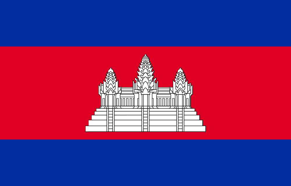
Cambodia at a glance
- Capital
- Phnom Penh
- Quiz continent
- Asia
- Languages in reference record
- Khmer
- Currency
- Cambodian Riel (CHR)
- Population
- 17,847,982 (2025, World Bank)
- Area
- 181,035 km²
- Coastal setting
- Not landlocked
- ISO codes
- KH / KHM
- Internet country suffix
- .kh
- Highest mountain
- Phnom Aoral, 1,810 m
- Large river
- Mekong
- Important lake
- Tonle sap
- Temple area at
- Siem Reap
- Independence
- 9 November 1953
- Sea access
- Gulf of Thailand
Cambodia Flag: Design, Meaning and History
The flag has a blue stripe at the top and bottom and a red stripe twice as high in the middle. In the red field stands a stylized white temple facade with three striking towers. She represents Angkor Wat. The building is thus not only a decorative coat of arms, but a recognizable historical monument.
Blue and red are traditional Cambodian colors. The temple motif connects the current national flag with the older Khmer Empire, without simply continuing its political situation. Cambodia used several very different flags in the 20th century. For the quiz, the blue-red-blue form shown here with the white Angkor-Wat motif is decisive.
Capital: Phnom Penh
Phnom Penh is located at a significant confluence of the Mekong and Tonle-Sap River, near the beginning of the Bassac. The city is the political and economic center of the country. Their location makes it clear why river shipping, seasonal water levels and flood plains are so important to Cambodia’s geography.
Phnom Penh is not the city of Angkor temples: these are located near Siem Reap in the northwest. The distinction helps in learning because the most famous monument of a country does not automatically stand in its capital. Angkor represents former centers of the Khmer empire, Phnom Penh the political capital of today's state.
Practise this capital →Cambodia: Geography, History and Culture
Large parts of the country consist of low plains around Mekong and Tonle Sap. Edge mountains, including the Cardamom Mountains in the southwest, form a clear contrast. According to the Factbook archive, the Phnom Aoral reaches 1,810 meters. The coast opens to the Gulf of Thailand and connects the otherwise strongly inland land with the sea.
The Tonle Sap is part of an exceptional seasonal water system. In the case of high Mekong water, the direction of flow of its connecting flow can be reversed; the sea area then increases significantly. Fishing, agriculture and settlements are associated with this rhythm. The lake can therefore not be meaningfully described as water bodies with a year-round unchangeable size.
Khmer is the official language and is written in its own writing. The monuments of Angkor document Hindu and Buddhist traditions as well as extensive hydraulic engineering facilities. In the 20th century, the country experienced colonial rule, war and the violence of the Khmer Rouge. This history requires a concrete temporal arrangement; it should not be obscured by the image of an exclusively ancient temple culture.
Angkor as a Cultural Landscape
UNESCO has been protecting Angkor since 1992. The area includes many monuments and settlement remains and extends far beyond the individual temple of Angkor Wat.
Water with changing direction
The Tonle-Sap River connects Lake and Mekong. Its seasonal change of direction explains the large-scale flooding and wealth of fish habitats.
Temple on the Flag
Angkor Wat is both a cultural site and a national motif. The three-door representation is easier to see for the flag quiz than the details of the real building.
Explore neighbouring and related places
 Laos
 Thailand
 Vietnam
What did you discover?
Sources and image credits
This English article draws on the institutional sources listed below. Figures and memberships retain their stated reference dates.
Source record: 2 November 2026. A translation does not change the reference date of a figure or membership list.
- github.com/factbook/factbook.json/blob/144d6977b2b01ac1cbd220de754c0a005616760b/east-n-southeast-asia/cb.json
- data.worldbank.org/indicator/SP.POP.TOTL
- mcfa.gov.kh/world-heritage/angkor/
- github.com/mledoze/countries