Myanmar (Burma) Flag, Capital and Country Facts
Myanmar lies between South Asia, China and the Southeast Asian mainland. The Ayeyarwady connects vast inland landscapes with its delta by the sea. Naypyidaw is the capital, Yangon the former political center and a major port city. The yellow-green-red flag with a white star can be distinguished from older flags of the country also known as Burma.
Test your knowledge →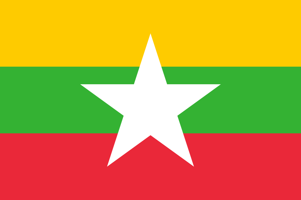
Myanmar (Burma) at a glance
- Capital
- Naypyidaw
- Quiz continent
- Asia
- Languages in reference record
- Burmese (official); numerous other languages, including Shan, Karen and Chin languages
- Currency
- Kyat (MMK)
- Population
- 54,850,648 (2025, World Bank)
- Area
- 676,578 km²
- Coastal setting
- Not landlocked
- ISO codes
- MM / MMR
- Internet country suffix
- .mm
- Former capital
- Yangon
- Large river
- Ayeyarwady/Irrawaddy
- Independence
- 4 January 1948
- Other name form
- Burma/Burma
- Flag changes
- 2010
- World Heritage
- Bagan since 2019; Pyu cities since 2014
Myanmar (Burma) Flag: Design, Meaning and History
Three equally high horizontal stripes are in yellow, green and red. A large white five-pointed star lies in the middle and extends beyond the green stripe into the neighboring colors. This is the most important difference to the similarly arranged Lithuanian flag, which has no star.
The design was introduced in 2010. Their colors pick up older flag colors; however, concrete political history should not be translated into a fictitious meaning of each color. In the quiz you can see today's tricolor, not the former red flag with blue corner field and white emblem.
Capital: Naypyidaw
Naypyidaw, also written Nay Pyi Taw, is the capital of Myanmar. The newly created city is located inland and took over the capital function of Yangon in the course of the relocation from 2005. The United Nations lists Nay Pyi Taw as its capital; this classification takes precedence over deviating older U.S. representations in the Factbook archive.
Yangon remains an important reference point as a former capital and port city. Anyone who confuses both places mixes historical significance with today's capital function. Naypyidaw as an inland location and Yangon further south also show that political administration and sea-oriented economic connections can be spatially divided.
Practise this capital →Myanmar (Burma): Geography, History and Culture
A central lowland with the Ayeyarwady is surrounded by mountain ranges to the west, north and east. In the south, coasts open to the Gulf of Bengal and the Andaman Sea. Between high mountains, river valleys, delta and long coasts there are great landscape differences. Myanmar is therefore neither exclusively a delta country nor a continuously mountainous inland area.
The monsoon determines large parts of the year, but the precipitation is distributed very differently regionally. The Ayeyarwady Delta is an important agricultural area and at the same time endangered by tropical cyclones and flooding. The rivers connect the inland area with the coast. Their importance for settlements and agriculture explains why they are also indispensable in an overview of the country's history.
Burmese is an official language and many other languages are spoken. Shan, Karen, Chin and other communities have their own historical and linguistic references. The country became independent from Britain on January 4, 1948. Armed conflicts and political crises are important for the present; however, individual current power or security data must be dated and cannot be seriously updated from the archive status in 2025.
Bagan
Bagan became a UNESCO World Heritage site in 2019. The large historical sacred landscape is an important reference point for Buddhist architecture. It is located inland and shows a different historical layer than the new capital or the colonial port city of Yangon.
Pyu cities
The old cities of Pyu have been on the World Heritage List since 2014. The entry leads to an early phase of the country’s urban history. Together with Bagan, he makes it clear that Myanmar’s cultural history goes back far before British rule and independence.
A river as an axis
The Ayeyarwady is a central north-south connection. Its delta forms a completely different landscape than the northern mountains. This transition helps to understand the great diversity within a single state through a coherent water system.
Explore neighbouring and related places
 Bangladesh
 China
 India
 Laos
 Thailand
What did you discover?
Sources and image credits
This English article draws on the institutional sources listed below. Figures and memberships retain their stated reference dates.
Source record: 2 November 2026. A translation does not change the reference date of a figure or membership list.
- github.com/factbook/factbook.json/blob/144d6977b2b01ac1cbd220de754c0a005616760b/east-n-southeast-asia/bm.json
- data.worldbank.org/indicator/SP.POP.TOTL
- whc.unesco.org/en/statesparties/mm
- data.un.org/legacy/en/iso/mm.html
- github.com/mledoze/countries