Vietnam Flag, Capital and Country Facts
Vietnam stretches elongated along the eastern side of the Indo-China Peninsula. Hanoi is located in the north, Ho Chi Minh city in the south. Between the Red River delta and the Mekong Delta, narrow coastal plains and mountain ranges connect very different landscapes; the great north-south extent explains differences in climate, settlement and regional history.
Test your knowledge →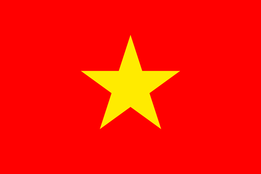
Vietnam at a glance
- Capital
- Hanoi
- Quiz continent
- Asia
- Languages in reference record
- Vietnamese; also including Khmer, Hmong and other minority languages
- Currency
- Vietnamese Đồng (VND)
- Population
- 101,598,527 (2025, World Bank)
- Area
- 331,212 km²
- Coastal setting
- Not landlocked
- ISO codes
- VN / VNM
- Internet country suffix
- .vn
- Highest mountain
- Fansipan, 3.144 m according to the archive
- Northern river delta
- Red river
- Southern river delta
- Mekong
- National holiday
- 2 September
- Historic Port City
- Hội anan
- Former imperial residence
- Huế�
Vietnam Flag: Design, Meaning and History
A yellow five-pointed star stands in the middle of a red field. Other stripes, lettering or coats of arms are missing. The clear design is easy to recognize, but requires attention to the number of stars: Vietnam has a single large star, while other red state flags carry several stars or additional signs.
In official symbolism, red is associated with revolution and shed blood. The five peaks of the star are related to social groups that are to build the socialist state together. This interpretation belongs to the political state sign world; it describes the symbolic claim of the flag and no complete sociological division of the present population.
Capital: Hanoi
Hanoi is located in the north on the Red River. The name is declared analogously as within the river and refers to the river position. The capital is distinguishable from Ho Chi Minh City, the former Saigon. Both cities have great importance, but only Hanoi fulfills today's national capital function.
The Thăng Long Imperial Citadel in Hanoi is a UNESCO World Heritage site. It connects the current capital with older centers of rule, whose history begins well before the modern state. In addition, Huế in central Vietnam stands for another imperial tradition of residence. Historical capital cities and today's political responsibilities should therefore be kept apart in time.
Practise this capital →Vietnam: Geography, History and Culture
The north has mountains and the delta of the Red River, the south the great Mekong Delta. In between are central highlands and often narrow coastal plains. According to the Factbook archive, the Fansipan reaches 3,144 meters. The elongated shape makes Vietnam unmistakable on the map and connects different watersheds via a narrower middle part of the country.
Monsoon and latitude affect the climate. The north shows different seasonal conditions than the more tropical south; mountain ranges additionally alter precipitation. Rice farming is particularly associated with the delta landscapes. This explains the close connection between rivers, fertile plains and settlement density without reducing the entire land to lowland agriculture.
UNESCO leads, among others, Hạ Long, Hội An, Huế and Tràng An. Hạ Long and the neighboring island spaces show karst landscapes by the sea; Hội An preserves the history of a port city. Vietnamese is an official language, while many minority languages are spoken especially in highland and border regions. The National Day on September 2 commemorates the Declaration of Independence of 1945.
Two large deltas
The Red River characterizes the north, the Mekong the south. The two deltas are not part of the same river system. Their assignment helps to spatially distinguish Hanoi and the southern economic area and to better understand Vietnam’s elongated form.
Hội An as a port city
The UNESCO heritage preserves testimonies of historical trade links. It complements the political history of Hanoi with a maritime city history: ports mediate exchange between regions, while residence cities have other historical functions. Both types belong to the cultural spectrum of Vietnam.
Karst on the sea
The limestone landscapes of Hạ Long are among the striking nature pictures of the country. Its towers and islands are geologically different from a volcanic archipelago. Landscape forms are sometimes similar in the picture, but have different origin stories.
Explore neighbouring and related places
 Cambodia
 China
 Laos
What did you discover?
Sources and image credits
This English article draws on the institutional sources listed below. Figures and memberships retain their stated reference dates.
Source record: 2 November 2026. A translation does not change the reference date of a figure or membership list.
- github.com/factbook/factbook.json/blob/144d6977b2b01ac1cbd220de754c0a005616760b/east-n-southeast-asia/vm.json
- data.worldbank.org/indicator/SP.POP.TOTL
- whc.unesco.org/en/statesparties/vn/
- github.com/mledoze/countries