Syria Flag, Capital and Country Facts
Syria lies between the eastern Mediterranean and the arid landscapes of the pre-Asian inland. Damascus developed on an oasis of the Barada and is one of the historical cities of the region. The green-white-black flag shown here with three red stars takes into account the change of 2025 and differs significantly from the previously used two-star pattern.
Test your knowledge →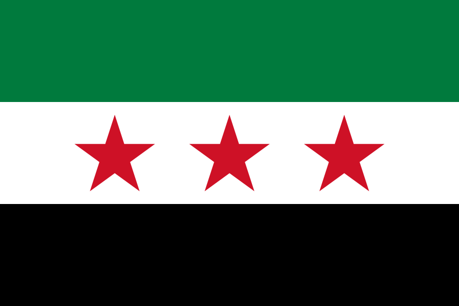
Syria at a glance
- Capital
- Damascus
- Quiz continent
- Asia
- Languages in reference record
- Arabic; including Kurdish, Armenian and Aramaic languages
- Currency
- Syrian pound (SYP)
- Population
- 25,620,427 (2025, World Bank)
- Area
- 185,180 km²
- Coastal setting
- Not landlocked
- ISO codes
- SY / SYR
- Internet country suffix
- .sy, سوريا.
- Capital river
- Barada
- Oasis of Damascus
- Ghouta
- Large river in the east
- Euphrates
- Sea
- Mediterranean Sea
- Independence
- 17 April 1946
- Old Town as a World Heritage Site since
- 1979
Syria Flag: Design, Meaning and History
Three equally high horizontal stripes form the flag: green above, white in the middle and black below. In the white stripe stand three red five-pointed stars next to each other. Their number and color are crucial. The former red-white-black flag with two green stars is expressly not shown here.
The pattern ties in with the Syrian independence flag of the 20th century and was used again after the political upheaval at the end of 2024. The Syrian cultural administration describes this green-white-black form with three red stars as the official flag. Historical meanings of stars and colours are to be distinguished from present-day political readings; an unchanged individual interpretation across all epochs would be too simplistic.
Capital: Damascus
Damascus is located in southwestern Syria on the edge of Ghouta Oasis. The barada enabled agriculture and supply in an environment with drier landscapes. The capital is not a seaport; its historical importance is based on oasis economy, land routes and its role as a political and religious centre.
The old town has been a UNESCO World Heritage site since 1979. The Umayyad Mosque stands in a room with older Roman and Christian building layers. This makes the long sequence of different city histories visible. The widespread statement of the “oldest city in the world” is not verifiable without precise definition; a long and important settlement history can be clearly proven.
Practise this capital →Syria: Geography, History and Culture
The narrow Mediterranean coast is followed by western mountain ranges; further inland semi-arid and desert areas predominate. The Euphrates crosses the east and connects Syria with Turkey and Iraq. Coast, oases and river valleys offer very different conditions for settlement and agriculture, which cannot be explained by a single climate concept.
Arabic is the predominant language; other languages and religious communities are part of the country’s historical diversity. Ancient cities, trading centers and medieval buildings show connections between the Mediterranean, Mesopotamia and the Arabian Peninsula. Damascus, Aleppo and Palmyra stand for different urban and landscape spaces instead of being interchangeable names for the same story.
The war that has been waged since 2011 has caused great human losses, displacement and damage to cities and cultural heritage. The political upheaval of 2024/2025 requires current sources, especially for state signs and institutions. The present page therefore adopts the verified flag form, but avoids current government lists. The Factbook serves expressly as an archive with a predominantly 2025 reference, not as a continuously updated presentation of the political situation.
Damascus as a stratified city
UNESCO describes the old town as an important historical ensemble. Various religious and architectural epochs meet in a confined space.
Three red stars
The current quiz motif can be recognized via star number and uppermost stripes. It does not confuse the new use with the former two-star flag.
Water on the desert edge
Barada and Ghouta explain the situation of Damascus. The Euphrates, on the other hand, forms another large-scale water and settlement corridor in the east.
Explore neighbouring and related places
 Iraq
 Israel
 Jordan
 Lebanon
 Türkiye
What did you discover?
Sources and image credits
This English article draws on the institutional sources listed below. Figures and memberships retain their stated reference dates.
Source record: 2 November 2026. A translation does not change the reference date of a figure or membership list.
- github.com/factbook/factbook.json/blob/144d6977b2b01ac1cbd220de754c0a005616760b/middle-east/sy.json
- data.worldbank.org/indicator/SP.POP.TOTL
- events.moc.gov.sy/en/about-flag
- whc.unesco.org/en/list/20
- github.com/mledoze/countries