Cyprus Flag, Capital and Country Facts
Cyprus lies in the eastern Mediterranean Sea between Europe, West Asia and North Africa. Its flag depicts the whole island and connects the outline with olive branches. The peace-oriented motive contrasts with an unresolved political division. Archaeological settlements, painted mountain churches and coastal towns make very different periods of island history visible.
Test your knowledge →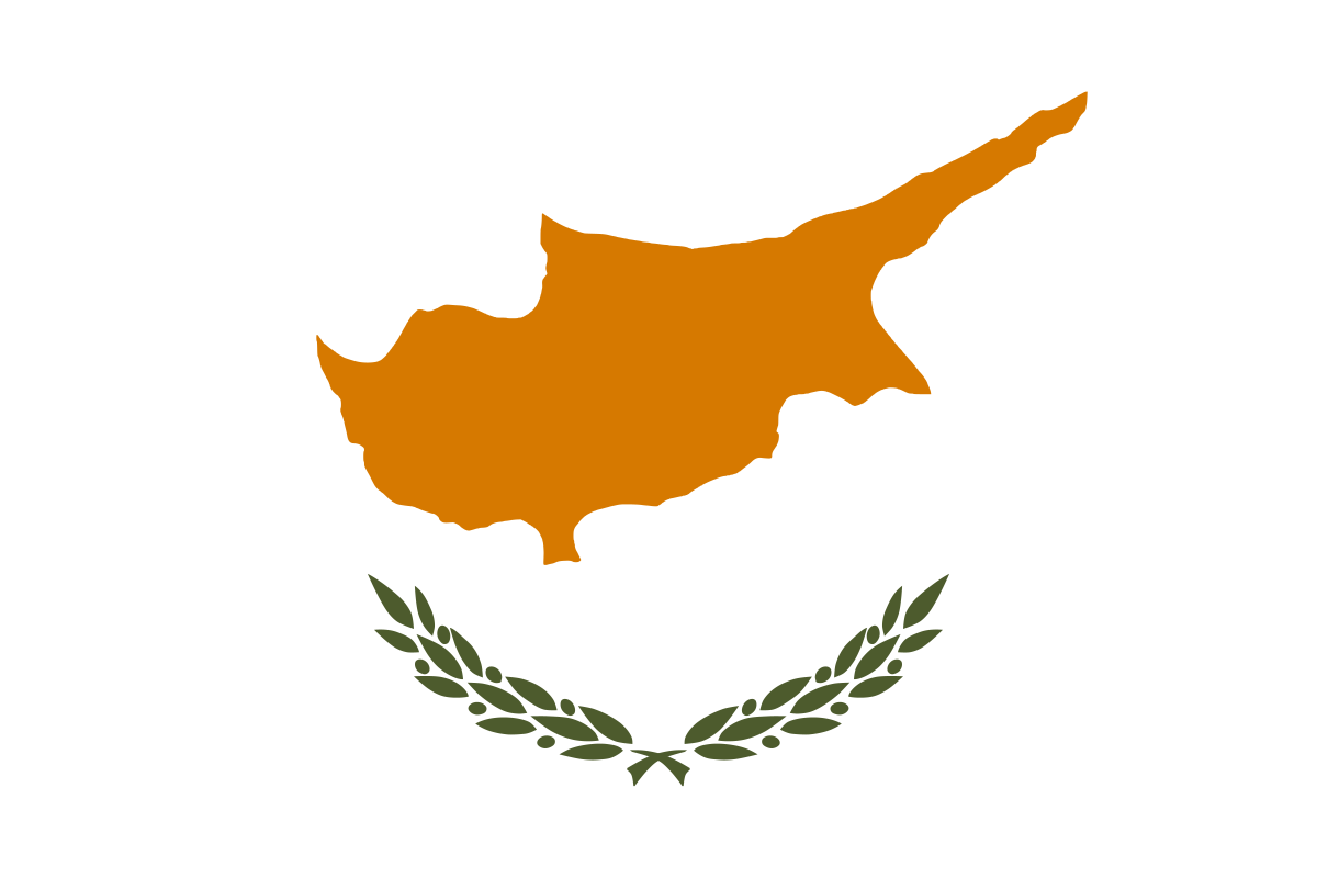
Cyprus at a glance
- Capital
- Nicosia
- Quiz continent
- Asia
- Languages in reference record
- Greek and Turkish
- Currency
- Euro (EUR)
- Population
- 1,370,754 (2025, World Bank)
- Area
- 9,251 km²
- Coastal setting
- Not landlocked
- ISO codes
- CY / CYP
- Internet country suffix
- .cy
- Highest mountain
- Olympus in Troodos, 1,951 m
- UN mission
- UNFICYPES
- Independence Year
- 1960
- National holiday
- 1 October
- Northeastern Peninsula
- Carpas
- Mountains
- Troodos
Cyprus Flag: Design, Meaning and History
On a white background, the copper-colored outline of the island of Cyprus appears. Among them are two crossed green olive branches. Both a cross and a crescent and star are missing. The map is not an additional territory, but the actual image motif; the long peninsula in the northeast helps with recognition.
The copper-colored representation recalls the historical significance of copper. The olive branches stand for peace and reconciliation between Greek and Turkish Cypriot communities. The flag belongs to the Republic of Cyprus and was introduced to independence in 1960. It must be distinguished from the flag of the North Cypriot administration recognised only by Turkey.
Capital: Nicosia
Nicosia is inland. Greek is the town of Lefkosia, Turkish Lefkoşa. The capital is divided by a buffer zone monitored by the United Nations. It also runs through the historic city center and distinguishes Nicosia from capitals whose political functions are organized on an undivided urban area.
UNFICYP describes several transitions in the city, including Ledra Street and Ledra Palace. Such a connection does not annul the political separation. For classification, the capital of the republic, effective administration of northern areas and international status must be kept apart. The geographical representation of the entire island on the flag does not decide these questions.
Practise this capital →Cyprus: Geography, History and Culture
In the west and south rises the Troodos Mountains with the Olympus as the highest mountain. In between and on the coast are plains and agricultural areas. Mediterranean summer drought makes water an important resource. The contrast between mountains and coastal areas also characterizes the distribution of historical settlements. The central Mesaoria plain lies between the mountain trains. It complements the image of a mountainous island with an important open settlement and agricultural area in the vicinity of the capital.
Greek and Turkish are the constitutional official languages. Political division since 1974 has greatly altered the spatial distribution of communities. The UN buffer zone is therefore more than an ordinary regional border. The Republic of Cyprus is a member of the European Union; the actual application of EU law in the north has a special status.
The cultural sites range from the Neolithic settlement of Choirokoitia to early Christian and Byzantine evidence. Paphos stands for ancient coastal culture, the painted churches for the mountain interior. This different location helps to compare the historical functions: port and city life on the one hand, rural religious buildings on the other. Basic data comes in addition from the factbook archive status of 2025.
Choirokoitia
The Neolithic settlement is a UNESCO World Heritage site. It traces far back to the epochs associated with today’s religious and political identities.
Troodos churches
The painted churches of the Troodos region are a joint World Heritage entry. Its interior preserves important murals.
Paphos
UNESCO runs Paphos as its own cultural site. Together with the mountain churches, the place shows the diversity of Cypriot heritage.
Explore neighbouring and related places
 Afghanistan
 Armenia
 Azerbaijan
 Bahrain
 Bangladesh
 Bhutan
What did you discover?
Sources and image credits
This English article draws on the institutional sources listed below. Figures and memberships retain their stated reference dates.
Source record: 2 November 2026. A translation does not change the reference date of a figure or membership list.
- github.com/factbook/factbook.json/blob/144d6977b2b01ac1cbd220de754c0a005616760b/europe/cy.json
- data.worldbank.org/indicator/SP.POP.TOTL
- whc.unesco.org/en/statesparties/cy
- unficyp.unmissions.org/en/about-buffer-zone
- commission.europa.eu/about/departments-and-executive-agencies/regional-and-urban-policy/green-line-regulation_en
- github.com/mledoze/countries