Vancouver: City Flag, History and Identity
Vancouver lies between coastal waters, wooded parking areas and the visible mountain rim in western Canada. This environment is also found in the city flag: blue and white form waves, green denotes the country. The city can therefore be well known through the interplay of port location, public waterfront and a long indigenous history.
Test your knowledge →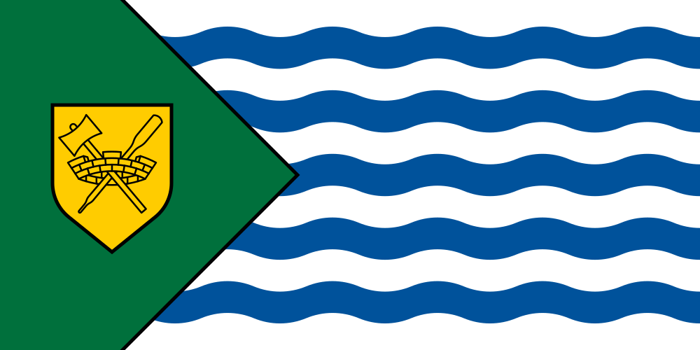
Vancouver at a glance
- Name
- Vancouver
- Country
- Canada
- Profile type
- City
- Province
- British Columbia
- Downtown location
- Peninsula
- Opening of Stanley Park
- 1888
- Name of the park
- Governor General Lord Stanley
- Historical heritage status
- Stanley Park: National Historic Site since 1988
- Water room in the park
- Lost Lagoon
- Parking gateway
- Seawall
- City Hall Opening
- 1936
- Former municipalities
- Point Grey and South Vancouver
The Flag of Vancouver
The flag has a green field with a golden emblem on the mast. On the rest of the surface, blue and white wave bands change. In the emblem, a crown of the wall and crossed tools are combined. The arrangement differs significantly from a common three-colored stripe flag and from the Canadian maple leaf on red and white.
The city explains the waves as an indication of the waters around Vancouver. The green stands for the land and forests from which a lot of prosperity was formerly created. The crown of the wall refers to the communal character of the sign. Thus, the flag combines landscape and city history without depicting a view of the entire city.
Vancouver: Location and Territorial Role
Vancouver is part of the Canadian province of British Columbia. The name can also mean a much larger urban region in everyday life; this is to be distinguished from the area of the city administration. Vancouver is not the same as Vancouver Island. Rather, the large-scale coastal situation explains why waterways were fundamental to its development.
The city center is located on a peninsula whose public spaces are characterized by coast and port. Stanley Park connects to this densely built-up urban landscape. At the transition between houses, waterfront and forest, it is particularly clear that a large city center and extensive green spaces can exist immediately next to each other.
Landscape, History and Culture
Stanley Park was established in 1888 as a city park. His name is reminiscent of then-Governor General Lord Stanley. However, the place had a history of being home to indigenous communities even before the park was set up. The representation as merely untouched nature would obscure this human past and the subsequent interventions in the landscape.
Canadian heritage conservation explicitly describes the park as a natural and cultural landscape. Forest, tide zone, landscaped gardens, paths, buildings and commemorative signs together form its historical value. Famous locations include Lost Lagoon, Brockton Point and the Seawall shore fortification. This diversity explains why the park is more than a single forest area.
The city administration also has a vivid historical building. The town hall was opened in 1936 and is related to the enlarged city after merging with Point Grey and South Vancouver. Its architecture provides a different approach than the port view: it tells of municipal organization, public representation and the urban growth of the twentieth century.
Seawall
The Seawall combines the experience of water with a designed urban infrastructure. Its walls and paths are part of the historic character of Stanley Park. Precisely because the promenade is a matter of course today, it is worth taking a look at its structural function: it enables a clearly guided movement along the coast.
Lost Lagoon
Lost Lagoon is a distinctive water space within the parkland. The monument documentation lists them as a designed freshwater element. This distinguishes it from the open sea waters on the outer edge of the park. This difference helps to read the landscape and prevents any water in the park from being confused with the Pacific Ocean.
Town Hall History
The town hall complements the well-known park and harbour pictures with the history of the municipal administration. It shows that the city limits have been historically altered. Point Grey and South Vancouver were previously independent communities; their incorporation is therefore a concrete part of the emergence of today’s Vancouver and not just a growth of individual suburbs.
Explore this country and nearby profiles
 Canada
 Toronto
 Ontario
 Quebec
What did you discover?
Take this flag into the quiz
Sources and image credits
This English article draws on the institutional sources listed below. Figures and memberships retain their stated reference dates.
Source record: 2 November 2026. A translation does not change the reference date of a figure or membership list.
- vancouver.ca/news-calendar/city-symbols.aspx
- pc.gc.ca/apps/dfhd/page_nhs_eng.aspx
- vancouver.ca/news-calendar/city-hall-architecture.aspx
- vancouver.ca/files/cov/vancouver-geography-facts-presentation.pdf
- vancouver.ca/parks-recreation-culture/stanley-park-story.aspx
- commons.wikimedia.org/wiki/File%3AFlag_of_Vancouver.svg