Ontario: Provincial Flag, Capital and Regional Profile
Ontario connects the densely populated landscapes of the Great Lakes with vast northern forest and rock areas. Toronto is provincial capital, while Ottawa is the capital of Canada. The red provincial flag contains the Union Jack and the coat of arms of Ontario. Waterways such as the Rideau Canal tell of the historical connections between settlements, defense and transport.
Test your knowledge →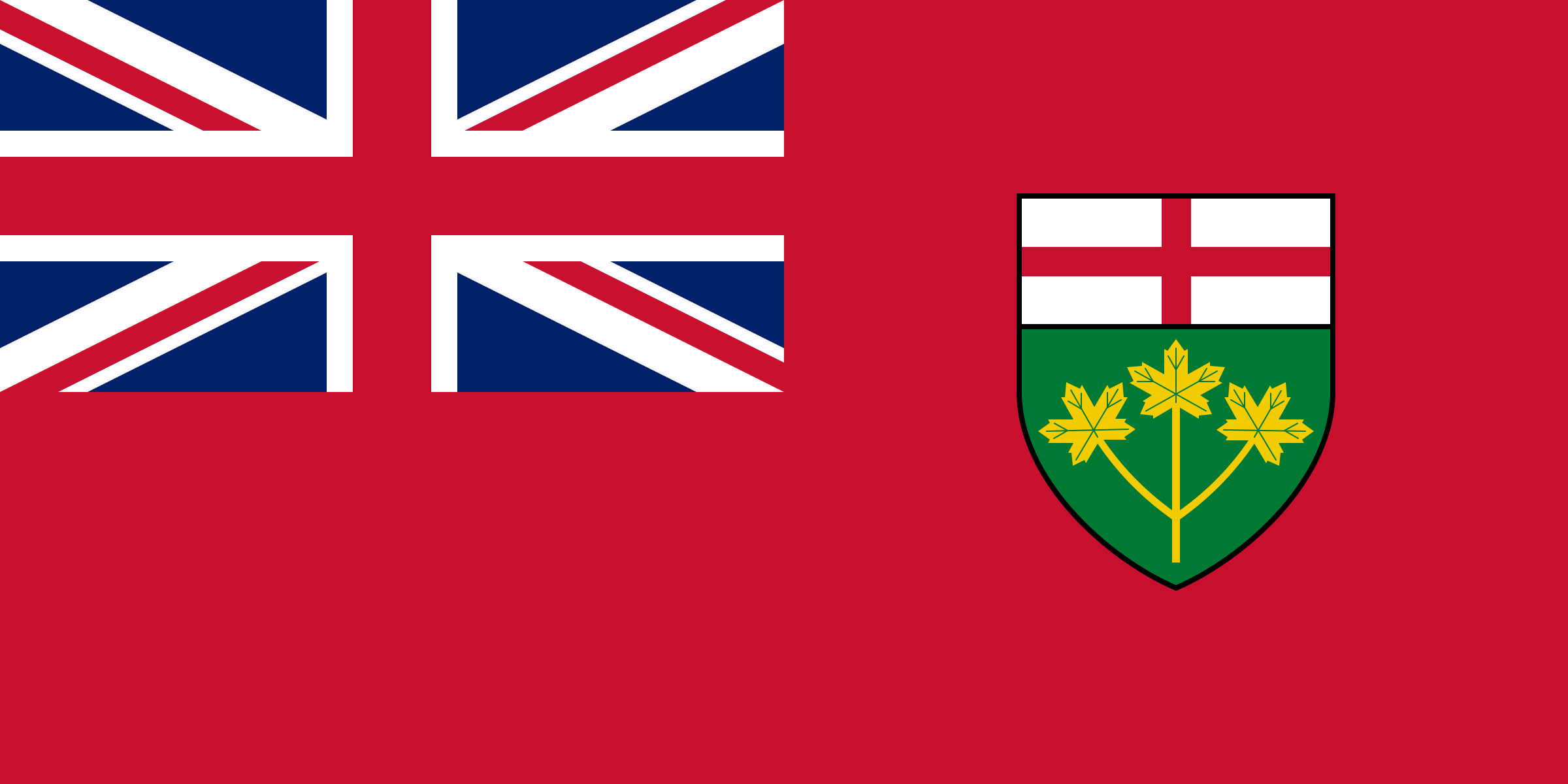
Ontario at a glance
- Name
- Ontario
- Country
- Canada
- Profile type
- Canadian province
- Administrative seat in source record
- Toronto
- Eastern neighbour
- Québec
- Western neighbour
- Manitoba
- Northern bays
- Hudson Bay and James Bay
- Greater geological area
- Canadian Shield
- Large freshwater island
- Manitoulin Island in Georgian Bay
- Accession to the Confederation
- 1867 as a founding province
- Rideau duct end points
- Ottawa and Kingston
- Official gemstone
- Amethyst, since 1975
The Flag of Ontario
The flag shown is red. In the upper hoist-side quarter stands the Union Jack, in the right half of the sign of Ontario. This connects a red cross of George on a white background with a green field and three golden maple leaves. The shield is smaller than the red free area around it.
The provincial flag was adopted in 1965 and first hoisted on May 21 of the same year. Its construction is based on the Canadian Red Ensign. The Federal Government explains the design of British heraldic traditions and the provincial shield; no invented meaning of each individual red or green area should be derived from this.
Ontario: Location and Territorial Role
Toronto and Ottawa have different political roles: Toronto belongs to the provincial administration, Ottawa to the federal level. Ontario borders Québec to the east and Manitoba to the west. To the north are Hudson Bay and James Bay; to the south, Great Lakes and the St. Lawrence River form an essential geographical framework.
The Canadian Shield separates fertile southern agricultural areas from the northern lowlands. Its ancient rocky landscapes are mineral rich. Thus, Ontario encompasses very different conditions for land use: agriculture, mining, forestry and urban industry can each be linked to certain landscape areas instead of appearing as evenly distributed activities.
Landscape, History and Culture
Water is a good key to the province. Manitoulin Island is located in Georgian Bay and is the largest island in a freshwater lake in the world. The extraordinary island world complements the large waters on the southern border. Also, Ontario’s name is declared by the government with an indigenous word for shiny or sparkling water.
The Rideau Canal runs from Ottawa via the Rideau and Cataraqui system to Kingston on Lake Ontario. It was built in the early 19th century mainly for military strategic purposes. Instead of continuously excavating a completely new trench, the system used dammed rivers and lakes connected by locks and canal sections.
Ontario was one of the four founding provinces of the Canadian Confederation in 1867, along with Québec, Nova Scotia and New Brunswick. However, his story begins much earlier. Algonkin and Iroquois linguistic communities lived in these spaces long before European colonization, shaping political, cultural and economic ties.
Rideau as a World Heritage Site
UNESCO praises the Rideau Canal as a particularly well-preserved North American example of a canal with dammed waters. The connection remained operational on its historical lines. Locks, watercourses and associated fortifications make the strategic planning of the early 19th century comprehensible in the area.
Manitoulin Island
The island in Georgian Bay is a concrete example of Ontario’s exceptional inland waters. Their classification as a freshwater island is important: comparisons with sea islands would affect a different geographical category. Such distinctions help to better capture the dimensions of the Great Lakes.
Provincial natural sign
The Amethyst was declared the official gemstone of Ontario in 1975. Among other things, occurrences are located on the northern shore of the Upper Lake near Thunder Bay. Thus, a mineral complements the more well-known plant and animal signs and refers to the geological significance of the Canadian shield for the province.
Explore this country and nearby profiles
 Canada
 Toronto
 Vancouver
 Quebec
What did you discover?
Take this flag into the quiz
Sources and image credits
This English article draws on the institutional sources listed below. Figures and memberships retain their stated reference dates.
Source record: 2 November 2026. A translation does not change the reference date of a figure or membership list.
- ontario.ca/page/about-ontario
- canada.ca/en/canadian-heritage/services/provincial-territorial-symbols-canada/ontario.html
- whc.unesco.org/en/list/1221
- destinationontario.com/en-ca/articles/beautiful-islands-ontario
- ola.org/en/visit-learn/teach-learn-play/about-ontario/more-about-ontario