Toronto: City Flag, History and Identity
Toronto is located on the northwestern shore of Lake Ontario and is characterized by river valleys, a long water edge and very different urban quarters. Its flag makes a building a symbol: the modern town hall with its curved towers. Thus, even the flag image leads to the question of how the city shapes its administration and its public space.
Test your knowledge →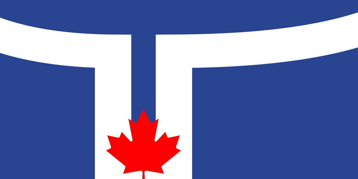
Toronto at a glance
- Name
- Toronto
- Country
- Canada
- Profile type
- City
- Sea
- Lake Ontario
- Riverside
- Northwest shore of Lake Ontario
- City Hall opens
- 1965
- Town Hall Architect
- Viljo Revell
- Municipal association
- 1998
- Former shoreline
- In the area of today's Front Street
- Re-election of the flag motif
- 1999 for the United City
- Flag designers
- Renato de Santis
The Flag of Toronto
A white, highly simplified line image stands on a deep blue background. It shows the two towers of the town hall; between their lower ends sits a red maple leaf. The shape also shows a T for Toronto. In the design idea, the leaf represents the meeting room between the towers.
The design is by Renato De Santis and was selected in 1974 after a competition. After the municipal unification of 1998, the new city decided in 1999 again for the familiar motif in adapted proportions. The current flag thus belongs to the united commune and not only to the former city centre.
Toronto: Location and Territorial Role
Toronto is part of the Canadian province of Ontario. The city is located on one of the Great Lakes, not immediately on the open ocean. Numerous streams and rivers move through the inclined terrain to Lake Ontario. Their valleys interrupt the development and create a network of landscape spaces within the big city.
The present commune was created in 1998 by the merger of several cities and a borough with Metropolitan Toronto. The name Toronto can also stand for a larger conurbation in everyday life. For flag and city administration, the municipal area is expressly meant here. The larger Toronto region is not an identical statistical unit.
Landscape, History and Culture
The lake was a transport space before the modern city developed. Indigenous communities used the location as a starting point for a connection to the Upper Great Lakes. The history of the shore therefore begins long before European forts and factories. Waterfront Toronto mentions the Mississaugas, Anishinaabeg, Haudenosaunee and Wendat as part of this historical context.
The visible coastline is heavily man-made. Since the nineteenth century, land has been poured into the lake to accommodate ports, industry and railways. The former shoreline was in the area of Front Street. A passage through today’s waterfront thus leads partly over soil, which was only created by decades of land recovery.
The town hall, which opened in 1965, shows a deliberately modern idea of communal representation. Finnish architect Viljo Revell won the international competition. Two curved office towers of different heights surround the round council hall. Their arrangement can be understood as a built equivalent of the flag motif and makes the connection between urban everyday life and graphic sign unusually direct.
City Hall and Nathan Phillips Square
The square in front of the town hall opens the view of both towers and the intervening meeting room. It is therefore a good place to compare the abstracted flag image with the actual construction. The town hall is a communal workplace and at the same time a publicly perceptible symbol of the entire city.
Toronto Islands
The islands offer views of Lake Ontario in one direction and the skyline in the other. They make the location of Toronto on the water particularly tangible. As a free space, they differ significantly from the densely built areas of the center, although both are connected via the same water edge.
Valleys and ravines
The urban natural areas include forested valleys, gorges and traces of older lake shores. The landscape cannot therefore be reduced to a straight line on today's Lake Ontario. If you want to understand Toronto geographically, you should also consider the water-shaped incisions that lead from the residential areas to the lake.
Explore this country and nearby profiles
 Canada
 Vancouver
 Ontario
 Quebec
What did you discover?
Take this flag into the quiz
Sources and image credits
This English article draws on the institutional sources listed below. Figures and memberships retain their stated reference dates.
Source record: 2 November 2026. A translation does not change the reference date of a figure or membership list.
- toronto.ca/city-government/awards-tributes/tributes/city-of-toronto-symbols/
- toronto.ca/city-government/data-research-maps/toronto-at-a-glance/
- toronto.ca/services-payments/venues-facilities-bookings/booking-city-facilities/city-hall/tours-points-of-interest/
- waterfrontoronto.ca/about-us/history-heritage
- toronto.ca/explore-enjoy/parks-recreation/places-spaces/beaches-gardens-attractions/
- commons.wikimedia.org/wiki/File%3AFlag_of_Toronto%2C_Canada.svg