Vorarlberg: State Flag, Capital and Regional Profile
Vorarlberg is located in the extreme west of Austria and connects the Bodenseeraum with alpine valleys and mountain landscapes. Bregenz is the state capital, but the Rhine Valley, Bregenzerwald and other sub-areas each have their own historical relationships. The red-and-white flag shows here the national coat of arms with the Montfort flag and thus differs from other similarly colored regional flags.
Test your knowledge →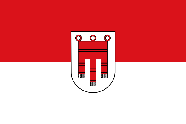
Vorarlberg at a glance
- Name
- Vorarlberg
- Country
- Austria
- Profile type
- Austrian federal state
- Administrative seat in source record
- Bregenz
- Situation within Austria
- The westernmost federal state
- Great lake
- Lake Constance
- Language area
- Alemannic
- Important valley axis
- Rhine Valley
- New Landtag
- First meeting in 1861
- Declaration of independence
- November 3, 1918
- First railway line
- Bludenz–Lindau, 1872
- Special road accessibility
- Kleinwalsertal via Germany
- Rhine Regulatory Treaty
- Austria–Switzerland, 1892
The Flag of Vorarlberg
The flag shown consists of a red upper and a white lower stripe. In the center stands a white sign with a red flag, the three lobes of which reach downwards. Rings and black details are part of the drawing of the coat of arms motif. The selection is expressly the form with country coat of arms.
The red flag motif is known as the Montfort flag. It is not an extra little flag cloth painted randomly, but a heraldic sign. For the recognition help the three lobes and the vertical arrangement. The red-and-white division alone would not distinguish Vorarlberg from Salzburg or Vienna.
Vorarlberg: Location and Territorial Role
Vorarlberg forms the westernmost Austrian country area. Bregenz is located on Lake Constance; other important settlement areas run through the Rhine Valley and into the mountain valleys. The situation in the Lake Constance region entails intensive relations with neighbouring areas. At the same time, Vorarlberg belongs linguistically to the Alemannic region, which shapes its cultural independence within Austria.
The landscapes are mainly assigned to the middle and high mountains. Nevertheless, the lower Rhine Valley region bundles important settlement and economic relations. A complete picture is therefore only created from the interplay of lake shores, valley axes and mountain locations. For a long time, these spatial differences influenced traffic, work and the connections between individual places.
Landscape, History and Culture
The present country emerged from several dominions. In the late Middle Ages and early modern times, different territories were brought together under Habsburg rule. The modern country context was therefore a historical development process. Older regional ties were preserved and still shape the diversity of landscape and place names today.
The Vorarlberger Landstand consisted of representatives of urban and rural courts. Nobility and clergy were not present in this country’s representation. Her responsibilities included tax issues and national defence. Their history must not be directly equated with today’s general democracy, but it does explain important local traditions of political self-representation.
In 1861, a Vorarlberger Landtag met again. On November 3, 1918, the Provisional State Assembly decided on Vorarlberg's independence as a state no longer under the governorship of Innsbruck. Transportation developments complemented this political history: in 1872, the Bludenz-Lindau rail link was opened and tied the country more closely into larger networks.
Lake Constance and Bregenz
The location of the capital on Lake Constance connects Vorarlberg with an international maritime and economic area. The later development of the port and shipping supplemented the rail connections. This makes it understandable that an Alpine country can at the same time have a strong relationship with a large lake and its neighboring shores.
Kleinwalsertal’
The Kleinwalsertal can only be reached from Germany via a road connection. This topographical peculiarity led to an economically important customs union agreement in 1891. The example illustrates how political affiliation and practical accessibility can fall apart and why local exceptions require an accurate geographical explanation.
Rhine regulation
A state treaty of 1892 between Austria and Switzerland initiated joint measures to regulate the Rhine. The punctures at Fußach and Diepoldsau followed in 1900 and 1923. The story illustrates how closely settlement protection, river design and international cooperation are linked in the Vorarlberg Rhine Valley.
Explore this country and nearby profiles
 Austria
 Vienna
 Salzburg
 Graz
 Linz
 Innsbruck
 Burgenland
What did you discover?
Take this flag into the quiz
Sources and image credits
This English article draws on the institutional sources listed below. Figures and memberships retain their stated reference dates.
Source record: 2 November 2026. A translation does not change the reference date of a figure or membership list.
- vorarlberg.at/web/landtag/-/der-vorarlberger-landtag-geschichte
- bildungsmedien.vobs.at/bildungsmedien/vorarlbergmedien/3500072-vorarlberg
- bildungsmedien.vobs.at/bildungsmedien/vorarlbergmedien/3500101-vorarlbergs-geschichte-in-bildern