Upper Austria: State Flag, Capital and Regional Profile
Upper Austria connects the Danube region around Linz with the Mühlviertel, the Innviertel and the lakes and mountains of the Salzkammergut. Between Böhmerwald and Dachstein are very different landscapes and historical economic areas. The white-red flag bears the national coat of arms here and thus marks a certain Austrian region despite a color combination that is also used elsewhere.
Test your knowledge →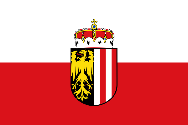
Upper Austria at a glance
- Name
- Upper Austria
- Country
- Austria
- Profile type
- Austrian federal state
- Administrative seat in source record
- Linz
- Traditional layout
- Four quarters
- Western subdivision
- Innerquarters
- Northern subdivision
- Mühlviertel
- Other quarters
- Hausruckviertel and Traunviertel
- Central flow axis
- Danube
- Northern mountainous area
- Bohemian forestry
- Southern Mountains
- Roofstone mountains
- Historical raw material
- Salt
- Official Geographic Information System
- DORIS
The Flag of Upper Austria
The selected flag has a white upper and a red lower stripe. In the middle stands the crowned coat of arms. The shield connects half a golden eagle on black field with vertical silver and red stripes. These details clearly distinguish the image from a simple white-red flag.
The existing file thus shows the variant with coat of arms and crown. Precisely because white and red also occur in Tyrol and other regions, the shield is important for the quiz. The vertical stripes in the coat of arms must not be confused with the horizontal stripes of the flag cloth.
Upper Austria: Location and Territorial Role
Upper Austria is located in the northern part of Austria. Linz is his state capital and is located on the Danube. The large river forms an important transport and settlement axis; at the same time, there are strong connections to the northern highlands, western agricultural areas and the Alpine landscapes of the south.
Traditionally, one distinguishes Innviertel, Hausruckviertel, Traunviertel and Mühlviertel. These names facilitate an initial spatial arrangement without making each municipality its own type of landscape. Official geoinformation services provide maps and search possibilities for places, rivers and mountains, thus supplementing the historical structure with precise today's orientation.
Landscape, History and Culture
The state geography ranges from the Böhmerwald to the Dachstein mountains. In the north, different elevations and rock spaces shape the picture than in the Alpine south. In between are Danube landscapes and more populated spaces. The change explains why Upper Austria is simultaneously associated with forest, agriculture, industry, lakes and high mountains.
The Salzkammergut is a historical cultural landscape whose development is strongly linked to salt. In Hallstatt, the deposit was already used in prehistoric times. The long economic importance of salt is reflected in settlements and architecture. A current landscape photo therefore shows at the same time a space of very old raw material extraction.
Upper Austria’s self-image combines economic development with tradition and cultural institutions. The industrial present and the history of rural areas belong together, even if they often appear separately on postcards. Linz and Hallstatt stand for different regional perspectives that complement each other within the same federal state.
Hallstatt Dachstein/Salzkammergut
The UNESCO site combines natural conditions with long-term human use. For a very long time, salt deposits formed a basis for regional prosperity. Hallstatt’s architecture is therefore not only a picturesque backdrop, but also a testament to economic history and the special location between the lake and mountains.
Four quarters
Innviertel, Hausruckviertel, Traunviertel and Mühlviertel form a traditional division of Upper Austria. For learners, they are a good starting point for locating regional names on maps. However, they do not replace the consideration of individual river valleys or an exact classification of political communities and districts.
Digital landscape view
The Upper Austrian spatial information system DORIS offers basic geographical information and specialist data. Such maps make the relationships between settlement, relief and water bodies traceable. This allows the general idea of the land between Böhmerwald and Dachstein to be translated into concrete places and visible spatial connections.
Explore this country and nearby profiles
 Austria
 Vienna
 Salzburg
 Graz
 Linz
 Innsbruck
 Burgenland
What did you discover?
Take this flag into the quiz
Sources and image credits
This English article draws on the institutional sources listed below. Figures and memberships retain their stated reference dates.
Source record: 2 November 2026. A translation does not change the reference date of a figure or membership list.
- land-oberoesterreich.gv.at/141017.htm
- doris.ooe.gv.at/service/basisinfo.aspx
- whc.unesco.org/en/list/806/
- land-oberoesterreich.gv.at/12130.htm