Tyrol: State Flag, Capital and Regional Profile
Tyrol is an Austrian federal state with two spatially separated parts: North Tyrol and East Tyrol. Alpine passes, river valleys and historical traffic routes explain its special position between northern and southern neighbouring areas. The white-red flag with the Tyrolean eagle marks today's federal state, while the historical term Tirol can also point beyond its Austrian borders.
Test your knowledge →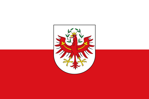
Tyrol at a glance
- Name
- Tyrol
- Country
- Austria
- Profile type
- Austrian federal state
- Administrative seat in source record
- Innsbruck
- Parts of land
- North Tyrol and East Tyrol
- Administrative Region of East Tyrol
- District of Lienz
- Regional centre of East Tyrol
- Lienz
- Other central locations
- Matrei and Sillian
- Mountain connection
- Felbertauers
- Historical Transition to the Habsburgs
- 1363
- Treaty on the division of Tyrol
- Saint-Germain, 1919
- South Tyrol today
- Part of Italy
- National Park with East Tyrolean share
- Tawls
The Flag of Tyrol
The selected flag shows white above and red below. In the middle there is a white shield with a red eagle. Golden details and a green wreath complement the coat of arms. Unlike a simple white-red flag, this variant therefore bears a clearly regional symbol on the flag cloth.
The Tyrolean eagle is the central sign of recognition. Its representation differs from the eagle in the Upper Austrian coat of arms, although both countries use white-red flags. The similar base area makes a close look at the shield especially important. In addition, the flag must not automatically be equated with all historical Tyrolean regions.
Tyrol: Location and Territorial Role
Innsbruck is located in northern Tyrol and is the state capital. East Tyrol corresponds to the district of Lienz and is spatially separated from the northern Tyrolean territory. Lienz therefore has a strong function as a regional administrative, educational and care centre. This division into two is one of the most important features of the Austrian federal state.
The name Tirol also has a historical and cross-border connection. South Tyrol and the Trentino are now in Italy. Together with the Austrian federal state, these spaces are in the tradition of the former Tyrol. Anyone who reads today's administrative map must therefore distinguish between historical landscape name and current nationality and nationality.
Landscape, History and Culture
Tyrol’s mountains are not a mere backdrop. Passes and valleys facilitated trade and military movement; raw material deposits contributed temporarily to prosperity. The location as a connection to the south made the space politically significant. The history of the country can therefore be explained particularly well by the connection between relief, traffic routes and domination.
In the thirteenth century, Meinhard II linked different ruling rights to a county of Tyrol. In 1363 it reached the Habsburgs. In addition to the princes, estates, towns and peasant court communities played an important role in the development of a sense of belonging. Historical unity was thus the result of political processes and not an immutable natural space.
The Treaty of Saint-Germain sealed the division of Tyrol in 1919. North and East Tyrol remained with Austria, the southern territories came to Italy. For today’s federal state, this history explains both its external borders and the spatial separation of East Tyrol. Older cultural and economic connections did not disappear completely.
East Tyrol and Lienz
The district of Lienz forms the entire East Tyrolean part of the country. Matrei and Sillian complement the district capital as other central places. The regional tasks of Lienz are particularly important in view of the separated situation; its importance cannot be deduced solely from a comparison with larger Austrian cities.
Connections across the mountain
Over the Felbertauern and through the Pustertal there are road connections to northern Tyrol. Such paths show how traffic reacts to the political and topographical situation. Mountain areas are held together by connections, at the same time distances and transitions remain important conditions for regional everyday life.
Tawls
The Hohe Tauern National Park also plays an important role in East Tyrol. Nature conservation and tourist use meet here in a high mountain landscape. For a country portrait, this perspective complements the history of passports and trade with the question of how alpine nature is preserved and conveyed today.
Explore this country and nearby profiles
 Austria
 Vienna
 Salzburg
 Graz
 Linz
 Innsbruck
 Burgenland
What did you discover?
Take this flag into the quiz
Sources and image credits
This English article draws on the institutional sources listed below. Figures and memberships retain their stated reference dates.
Source record: 2 November 2026. A translation does not change the reference date of a figure or membership list.
- tirol.gv.at/leicht-lesen/informationen-ueber-tirol/
- tirol.gv.at/kunst-kultur/landesarchiv/geschichte-archiv/
- tirol.gv.at/statistik-budget/statistik/regionsprofile/nuts-3/osttirol/
- tirol.gv.at/fileadmin/themen/gesellschaft-soziales/staatsbuergerschaft/Geschichte_2022.pdf