Styria: State Flag, Capital and Regional Profile
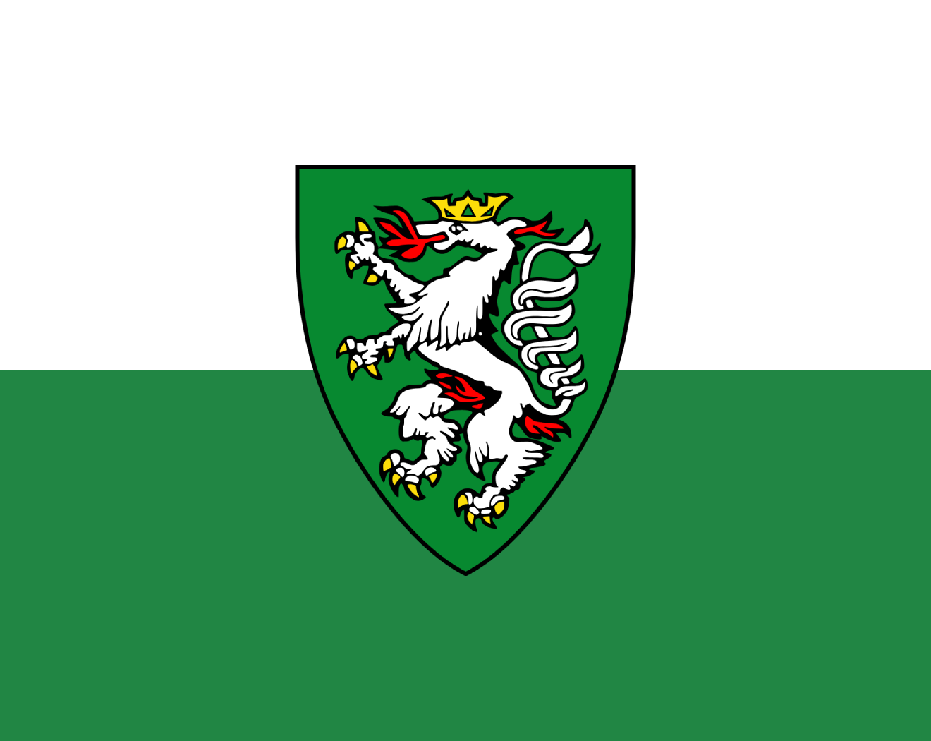
Styria connects alpine industrial and valley landscapes with forested heights and southern vineyards. Graz is its political and cultural centre, but Obersteiermark and the southern hill country each have their own profile. The white-green flag shows the Styrian Panther and thus translates a striking historical coat of arms into an easily recognizable landmark.
Test your knowledge →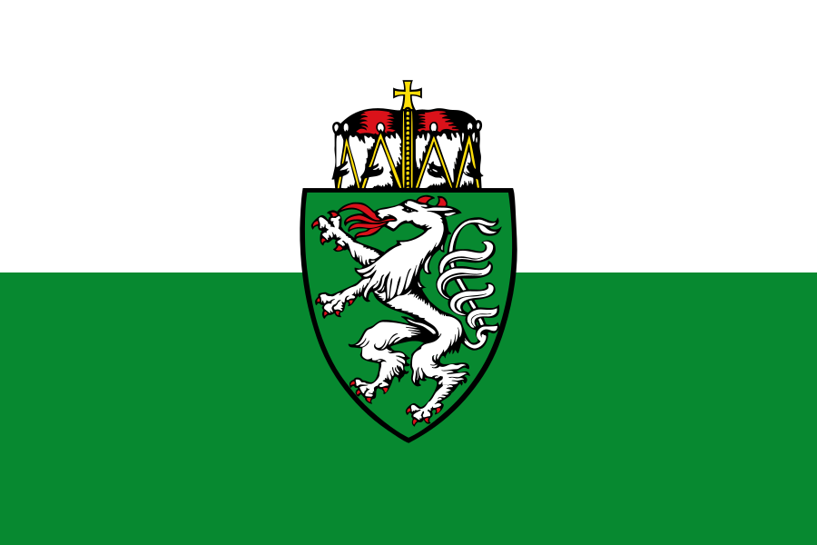
Styria at a glance
- Name
- Styria
- Country
- Austria
- Profile type
- Austrian federal state
- Administrative seat in source record
- Graz
- Border State
- Slovenia
- Large river
- Murder
- Highest summit
- High roof stone, 2,995 meters
- Largest lake
- Grundlsee
- Bynames
- Green mark
- Origin of the name
- Traungauer's main castle in Steyr
- Survey of the Duchy
- 1180
- Babenberger connection
- 1192
- UNESCO ensemble in Graz
- Historic Centre and Eggenberg Castle
The Flag of Styria
The existing flag is divided horizontally: above white, below green. In the center stands a green shield with a silver panther, from whose mouth flames strike. A heraldic headgear is shown above the shield. It is a coat of arms variant and not the mere white-green strip cloth.
The Styrian Panther is a heraldic mythical creature and should not be read like a zoological representation of a domestic animal. Especially the flames and the green shield make the assignment clear. The colors of the country alone would be less clear, because for example Saxony also uses a white-green flag.
Styria: Location and Territorial Role
Styria borders Slovenia in the south. Within Austria, it has neighbourhoods with several federal states. Graz is located on the Mur and fulfils the capital function. The river connects different Styrian areas and makes it clear that valley locations are of particular importance for settlement, transport and economic relations.
The mountainous Obersteiermark differs from the gentler hill spaces further south. Mining, iron hammers and steelworks characterised historical industrial landscapes, while the area around Leibnitzer Feld and the southern hills is linked to viticulture. Both landscapes belong to Styria and should not be played off against each other.
Landscape, History and Culture
The name Green Mark refers to the extensive forests of the country. The Dachstein forms the highest peak, the Grundlsee is the largest Styrian lake. Alpine influences in the north and Pannonian influences in the south and southeast contribute to different climatic conditions. This changes the vegetation and land use within the federal state.
The name of the country goes back to the main castle of the Traungau Counts in Steyr, which today is located in Upper Austria. This example shows that historical names do not necessarily come from places within today’s borders. In 1180 Styria was elevated to the duchy; in 1192 it came to the connection with the Babenbergers.
Graz preserves a diverse architectural heritage in its old town and in Schloss Eggenberg. UNESCO recognises the interaction of different influences from Central and Southern Europe. In addition, Styria is characterised by economic structural change: former heavy industry focuses complement each other with new activities, services and cultural facilities.
Graz World Heritage Site
The Historic Centre and Eggenberg Palace together form the UNESCO site of Graz. The connection makes it clear that urban history does not end at the borders of a narrow old town center. Civic, courtly and landscape elements contribute together to the statement of the ensemble.
Mur as a national axis
The Mur runs through an important part of the country and is closely connected to Graz. Their valleys link different landscapes, while lateral mountains and high altitudes form their own regional identities. The river is therefore a useful guide without being able to fully explain all Styrian subspaces.
Forests, mountains and wine
The contrast between alpine heights and southern wine landscapes is particularly striking. It is based on relief and climate, but also on historical use. A country portrait therefore gains in accuracy if it includes forests and industrial valleys as well as the well-known wine-growing regions in the south.
Explore this country and nearby profiles
 Austria
 Vienna
 Salzburg
 Graz
 Linz
 Innsbruck
 Burgenland
What did you discover?
Take this flag into the quiz
Sources and image credits
This English article draws on the institutional sources listed below. Figures and memberships retain their stated reference dates.
Source record: 2 November 2026. A translation does not change the reference date of a figure or membership list.
- landtag.steiermark.at/cms/beitrag/12321163/122783133/
- landesentwicklung.steiermark.at/cms/beitrag/12651400/141979572/
- landesentwicklung.steiermark.at/cms/dokumente/12650226_141979497/953097b2/Kleine%20Steiermark%20Datei%202020.pdf
- whc.unesco.org/en/list/931/