Carinthia: State Flag, Capital and Regional Profile
Carinthia lies in southern Austria between high mountains, wide basin landscapes and numerous lakes. The Drau connects many of its valleys and leads on to Slovenia. On the yellow-red-white national flag stands a historical coat of arms sign, which makes Carinthia also recognizable where the three colors without landscape reference alone would tell little about the federal state.
Test your knowledge →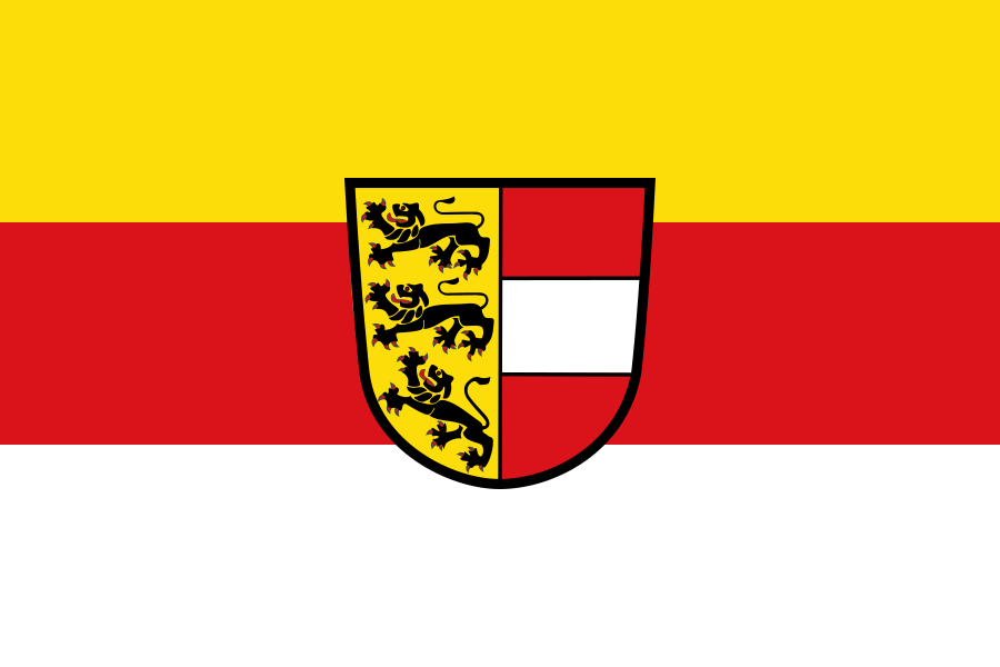
Carinthia at a glance
- Name
- Carinthia
- Country
- Austria
- Profile type
- Austrian federal state
- Administrative seat in source record
- Klagenfurt am Wörthersee
- Main river
- Draca
- Neighbouring countries
- Italy and Slovenia,
- Large basin
- Klagenfurter Becken
- Other basin
- Lavanttal basin
- Southern mountain range
- Caravans
- Inflow from Italy
- Gailitz
- Great lake
- Wörthersee’
- Ramsar river section
- Upper Drau
- Start of major river decommissioning operations
- Since 1990
The Flag of Carinthia
The flag shown consists of three horizontal stripes in yellow, red and white. In the middle is the Carinthian coat of arms. One half of the shield shows three black lions on a yellow background; the other connects a white transverse band with a red background. Here, therefore, an emblem-bearing variant is expressly selected.
The three lions and the white-red shield part are the most important details. They belong to the heraldic tradition of Carinthia, not to a representation of today's lakes or Alps. If you assign the flag, you should first check the stripe sequence and then read the sign as a regional confirmation.
Carinthia: Location and Territorial Role
Carinthia borders Italy and Slovenia and belongs to the Alpine-Adriatic region. Klagenfurt am Wörthersee assumes the capital function. Villach, Spittal an der Drau, St. Veit and Wolfsberg are other regional centers. The different cities are related to the large valleys and basins that bundle settlement and traffic.
The Drau is the central water axis. A large part of the Carinthian water leaves the country via them towards Slovenia. Tributaries reach Carinthia at the same time from East Tyrol, Styria and Italy. Hydrologically, the federal state therefore does not form a closed vessel, but a section of a larger cross-border river system.
Landscape, History and Culture
Mountain groups and pools change in a narrow space. Among the formative spaces are the Gurktal Alps, the Koralpe, the Carnic Alps and the Caravanques. The Klagenfurt basin and the Lavanttal basin interrupt the mountain scenery. This structure explains why there are clearly different landscapes within Carinthia.
Carinthian lakes are an essential part of his public perception. The Wörthersee stands next to other large lakes such as Millstätter See, Ossiacher See and Weißensee. The connection between water surfaces, settlements and mountains is particularly characteristic. However, it must not hide the fact that industry, agriculture and administration also belong to today's country.
The Upper Drau shows the connection between flow dynamics and human intervention. Regulations changed the river, while deconstruction measures since 1990 again made more natural structures possible. Alluvial forests and pioneer areas are just as important as the water itself. The protection of a river thus always affects its banks and adjacent valleys.
Upper Drau
The section described as the Ramsar area extends from Oberdrauburg to Draustau near Paternion. It is located in an inner alpine valley with different rock spaces at its edges. The river, alluvial forests and agricultural areas form a coherent landscape mosaic with diverse usage requirements.
Klagenfurter Becken
The basin makes it understandable why Carinthia has larger open settlement spaces despite its alpine location. The capital and its surroundings are embedded in this context. The landscape change between the basin floor and the mountain edge can therefore be read at the same time as the basis of settlement, traffic and regional everyday life.
Transboundary water
The Drau leads Kärntens Wasser further to Slovenia. At the same time, inflows from neighboring areas are added, including the Gailitz from Italy. This interconnectedness makes it clear why water monitoring and water protection have to be considered beyond national borders and why valley names are important geographical orientation aids.
Explore this country and nearby profiles
 Austria
 Vienna
 Salzburg
 Graz
 Linz
 Innsbruck
 Burgenland
What did you discover?
Take this flag into the quiz
Sources and image credits
This English article draws on the institutional sources listed below. Figures and memberships retain their stated reference dates.
Source record: 2 November 2026. A translation does not change the reference date of a figure or membership list.
- gis.ktn.gv.at/OGD/Geographie_Planung/Handbuch_Bodenfunktionsbewertung_K%C3%A4rnten.pdf
- bmluk.gv.at/themen/wasser/wasser-eu-international/europaeische-und-internationale-wasserwirtschaft/feuchtgebiete/ramsar/ramsar-obere-drau.html
- kaernten.at/b2b/service-mehr/presse/kaernten-auf-einen-blick/
- ktn.gv.at/DE/repos/files/ktn.gv.at/Abteilungen/Abt8/Dateien/Hydrographie/HD_Hydrologischer_Bericht_2013_HD%20Kaernten.pdf